

 Français (France)
  Nederlands (nl-NL)
 Of Hindu tradition, the Vijayanagara empire ruled for approximately 310 years, ± between 1336 and 1646 over all or part of South India and West India, during the Medieval Period.
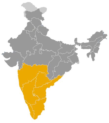
This map illustrates the maximum territory that the Vijayanagara empire Dynasty had reached at its height, covering the current regions of Goa, Karnataka, Kerala, Maharashtra and Tamil Nadu in India. Its main purpose is to provide a visual aid to understand the geographical extent of this dynasty. However, it's important to note that the contemporary borders of these regions may not necessarily coincide with the historical territories.
The Vijayanagara Empire and Its Role in Indian History
An imperial state rather than a single dynasty
The Vijayanagara Empire occupies a central place in the history of medieval India, especially in the political and cultural development of the south. Founded in 1336, it was not a single dynasty in the strict sense, but an imperial state ruled successively by several royal houses. Its main ruling dynasties were:
- the Sangama dynasty, associated with the foundation and early expansion of the empire;
- the Saluva dynasty, which came to power during a period of political instability;
- the Tuluva dynasty, under which the empire reached its greatest power;
- the Aravidu dynasty, which continued the imperial tradition after the disaster of Talikota.
The capital of the empire was Vijayanagara, identified with the present site of Hampi in Karnataka. Located on the banks of the Tungabhadra River, this city became one of the most remarkable urban and ceremonial centres of medieval India. Its temples, palaces, markets, fortifications and waterworks reflected the scale and ambition of imperial power.
A major power in southern India
The rise of Vijayanagara took place in a period of major political change. Northern India had already experienced the expansion of the Delhi Sultanate, while the Deccan and southern India were divided among regional kingdoms, military chiefs and emerging sultanates. Vijayanagara developed as a powerful southern empire able to compete with these neighbouring states and to integrate large parts of the Indian peninsula into a single political framework.
Its rulers presented themselves as protectors of order, royal authority and Hindu religious institutions. However, the empire should not be reduced to a simple religious reaction against Islamic powers. Its diplomacy and military organisation were pragmatic. Vijayanagara fought the Bahmani Sultanate and later the Deccan sultanates, but it also engaged in alliances, trade and cultural exchanges with Muslim states. Its armies included different military traditions, and its court was aware of the strategic value of cavalry, firearms, fortifications and long-distance trade.
Political organisation and imperial authority
The political system of Vijayanagara combined central authority with regional delegation. The emperor, often known by titles such as raya or maharaya, stood at the top of the imperial hierarchy. He controlled the capital, major military campaigns, diplomatic relations and symbolic kingship. Yet the administration of distant provinces depended heavily on governors, military commanders and local chiefs.
This structure allowed the empire to control extensive territories across Karnataka, Andhra, Tamil regions and parts of the southern Deccan. It also made rapid military mobilisation possible. The same system, however, contained internal weaknesses. Powerful regional commanders could become semi-autonomous, especially when the central court was weakened by succession disputes or military defeat. This tension between imperial unity and regional autonomy shaped the history of Vijayanagara from its foundation to its decline.
Cultural patronage and regional languages
The cultural role of Vijayanagara was considerable. The empire supported Sanskrit learning, temple ritual and classical religious traditions, but it also encouraged the development of major regional languages. Kannada, Telugu and Tamil literary cultures benefited from courtly and religious patronage. Under Krishnadevaraya, one of the most celebrated rulers of the Tuluva dynasty, Telugu literature flourished particularly strongly.
Krishnadevaraya himself is remembered as a ruler, military leader and literary patron. His reign from 1509 to 1529 is often regarded as the high point of the empire. During this period, Vijayanagara projected both military strength and cultural refinement. The court attracted poets, scholars, religious teachers, administrators and artists, making it one of the great intellectual centres of early sixteenth-century South India.
Architecture, temples and sacred kingship
The most visible legacy of Vijayanagara is architectural. Hampi preserves the remains of an imperial city where sacred, political and commercial spaces were closely connected. Monumental temple complexes, pillared halls, processional streets, water tanks, gateways and carved mandapas illustrate the distinctive style associated with the empire.
Temples played a role far beyond worship. They were centres of landholding, redistribution, artistic production and social organisation. Royal patronage of major temples strengthened the legitimacy of the rulers and linked imperial authority to sacred geography. The Virupaksha temple at Hampi, already important before the rise of the empire, became deeply associated with the identity of Vijayanagara. Other religious foundations across southern India also benefited from imperial support.
Economic strength and commercial networks
The economic power of Vijayanagara rested on agriculture, irrigation, taxation, craft production and trade. The empire invested in reservoirs, canals and other water-management systems that supported cultivation in semi-arid regions. Agricultural surplus helped sustain cities, armies, temples and administrative institutions.
Trade was equally important. Vijayanagara was connected to inland routes and to the maritime networks of the Indian Ocean. Horses imported from Arabia and Persia were essential for warfare and were acquired through coastal trade. Textiles, spices, precious stones, metals and luxury goods circulated through its markets. Foreign travellers described the capital as wealthy, populous and commercially active, although such accounts must be read with caution.
Decline after Talikota and long-term influence
The Battle of Talikota in 1565 was a decisive turning point. A coalition of Deccan sultanates defeated the forces of Vijayanagara, and the imperial capital was devastated. The empire did not disappear immediately, and the Aravidu dynasty continued to rule from other centres. Yet the political and symbolic heart of Vijayanagara was broken, and regional governors increasingly asserted their independence.
Despite its decline, the empire left a lasting mark on Indian history. Its administrative practices, temple architecture, military organisation and cultural patronage influenced later states in Karnataka, Andhra and Tamil Nadu. The Nayaka polities that emerged in the south inherited much from the Vijayanagara system. Through Hampi and its wider cultural legacy, Vijayanagara remains one of the most important examples of imperial state formation in medieval South India.
The Vijayanagara Empire was not a single dynasty, but an imperial state ruled successively by the Sangama, Saluva, Tuluva and Aravidu dynasties. Its rulers often bore the title raya or maharaya; the general designation of emperors is used here to reflect the imperial framework. The reign dates are indicative and may vary according to historical chronologies.
Sangama dynasty
- Harihara I (1336–1356) • Founder of the empire with his brother Bukka Raya I, he established Vijayanagara power in the southern Deccan.
- Bukka Raya I (1356–1377) • He consolidated the emerging state and extended its authority across several regions of southern India.
- Harihara II (1377–1404) • His reign strengthened imperial administration and expanded Vijayanagara influence toward the western coast.
- Virupaksha Raya I (1404–1405) • His reign was brief and belongs to a transitional phase within the Sangama dynasty.
- Bukka Raya II (1405–1406) • He ruled briefly before the accession of Deva Raya I.
- Deva Raya I (1406–1422) • He developed the empire’s military capacity and continued conflicts with the Deccan sultanates.
- Ramachandra Raya (1422) • His reign was very short and remains poorly documented in Vijayanagara chronologies.
- Vira Vijaya Bukka Raya (1422–1424) • He governed during a short succession phase before the reign of Deva Raya II.
- Deva Raya II (1424–1446) • He was one of the most powerful Sangama rulers and encouraged the political, military and cultural expansion of the empire.
- Mallikarjuna Raya (1446–1465) • His reign was marked by the gradual weakening of central authority.
- Virupaksha Raya II (1465–1485) • He ruled during a period of internal crises and increasing external pressure.
- Praudha Raya (1485) • The last Sangama ruler, he was quickly displaced by Saluva Narasimha, who founded a new dynasty.
Saluva dynasty
- Saluva Narasimha Deva Raya (1485–1491) • Founder of the Saluva dynasty, he attempted to restore imperial authority after the disorders of the late Sangama period.
- Thimma Bhupala (1491) • His reign was very brief and took place during an unstable succession.
- Narasimha Raya II (1491–1505) • He ruled largely in name, while effective power gradually passed to the Tuluva military leaders.
Transition to the Tuluva dynasty
- Tuluva Narasa Nayaka (1491–1503, de facto regency) • A general and regent, he exercised real power without always being counted as a crowned emperor.
Tuluva dynasty
- Vira Narasimha Raya (1505–1509) • The first crowned Tuluva ruler, he consolidated his dynasty’s seizure of power.
- Krishnadevaraya (1509–1529) • He brought the empire to its political, military, economic and cultural height.
- Achyuta Deva Raya (1529–1542) • His reign maintained imperial strength, despite growing tensions within the court.
- Venkata I (1542) • He ruled briefly during a troubled succession after the death of Achyuta Deva Raya.
- Sadasiva Raya (1542–1570, nominal reign) • He retained the imperial title, while Aliya Rama Raya exercised most of the power until the Battle of Talikota.
- Aliya Rama Raya (1542–1565, de facto power) • The dominant political figure of the empire, he was killed at Talikota in 1565, a decisive event in Vijayanagara’s decline.
Aravidu dynasty
- Tirumala Deva Raya (1570–1572) • Founder of the Aravidu dynasty, he reorganized the empire after the disaster of Talikota.
- Sriranga I (1572–1586) • He tried to preserve imperial authority in a context of territorial fragmentation.
- Venkata II (1586–1614) • He was one of the last powerful rulers of Vijayanagara and temporarily stabilized the Aravidu state.
- Sriranga II (1614) • His reign was very brief and marked by a violent succession crisis.
- Ramadeva Raya (1617–1632) • He ruled after a period of dynastic conflict and maintained reduced authority.
- Venkata III (1632–1642) • His reign took place in a severely weakened empire under strong regional pressure.
- Sriranga III (1642–1646) • The last effective emperor of Vijayanagara, he retained only limited authority before the political disappearance of the empire.
The Geographical Expansion of the Vijayanagara Empire in India
A southern imperial power centred on the Deccan
The Vijayanagara Empire, founded in 1336, was not a single dynasty but an imperial state ruled successively by several dynastic houses, chiefly the Sangama, Saluva, Tuluva and Aravidu dynasties. Its geographical expansion was one of the defining features of its historical role. From its capital at Vijayanagara, now identified with Hampi in Karnataka, the empire came to dominate large parts of southern India and to influence the political balance of the Deccan, the Tamil country, the Andhra region and the western and eastern coasts.
The original centre of power lay in the Tungabhadra valley, a strategically protected landscape of granite hills, riverine agriculture and established routes across the southern Deccan. This region offered both defensive advantages and access to important political and commercial corridors. From this base, the early rulers expanded their authority into surrounding territories, gradually transforming a regional kingdom into one of the largest imperial formations of medieval South India.
Control over Karnataka and the imperial heartland
Karnataka formed the political and symbolic heartland of Vijayanagara. The capital, major temples, royal enclosures, fortifications and administrative centres were concentrated in this region. Control over Karnataka gave the empire access to agricultural resources, mineral zones, inland trade routes and communications with the western coast.
The imperial heartland was not governed only through direct royal administration. Vijayanagara relied heavily on military governors, local chiefs and regional officers, often associated with the nayaka system. These figures collected revenue, maintained troops and administered territories in the name of the emperor. This structure allowed Vijayanagara to hold a large and diverse territory, but it also created powerful regional authorities whose loyalty depended on the strength of the central court.
Expansion toward Andhra and the eastern regions
The expansion eastward into Andhra and parts of Telangana was a major aspect of Vijayanagara’s territorial policy. These regions were agriculturally rich, strategically placed and connected to routes leading to the Bay of Bengal. They also formed a contested frontier between Vijayanagara, the Deccan sultanates and the Gajapati rulers of Odisha.
Control over the Andhra region brought military and economic advantages. Fortresses, irrigated lands and commercial centres strengthened the empire’s eastern presence. Under Krishnadevaraya, who ruled from 1509 to 1529, Vijayanagara achieved major successes against the Gajapati kingdom and secured influence over important parts of the Telugu-speaking region. This expansion also had cultural consequences, as the imperial court became closely associated with Telugu literary patronage while continuing to support Kannada, Sanskrit and Tamil traditions.
Influence over Tamil regions and southern plains
To the south, Vijayanagara extended its authority over large parts of the Tamil country. This region had long been shaped by the legacy of the Chola, Pandya and other regional powers. By bringing much of Tamil Nadu under imperial influence, Vijayanagara gained access to fertile plains, temple networks, pilgrimage centres and long-established commercial routes.
The empire often governed these southern territories through appointed military chiefs and governors. Over time, some of these representatives became increasingly autonomous. The Nayakas of Madurai, Thanjavur and Gingee emerged from this political environment. Initially linked to the imperial structure, they later developed as regional powers, especially after the weakening of Vijayanagara in the second half of the sixteenth century. Thus, the empire’s southern expansion reshaped the political geography of Tamil Nadu for generations.
Coastal access and maritime trade
The geographical ambitions of Vijayanagara were not limited to inland conquest. Access to the coasts was essential for economic and military reasons. On the western coast, the empire sought influence over ports connected to the Arabian Sea. These ports were vital for the importation of horses from Arabia and Persia, which were indispensable to South Indian warfare. They also linked the empire to the wider commercial networks of the Indian Ocean.
On the eastern coast, control or influence over ports of the Bay of Bengal facilitated trade with eastern India, Sri Lanka and Southeast Asia. Textiles, spices, precious stones, metals and luxury goods circulated through these networks. Coastal access increased the empire’s wealth and made Vijayanagara an important partner for foreign merchants, including the Portuguese after their arrival in the Indian Ocean at the end of the fifteenth century.
Northern frontiers and rivalry with the Deccan sultanates
The northern frontier was the most contested zone of Vijayanagara’s expansion. The empire repeatedly confronted the Bahmani Sultanate and, after its fragmentation, the Deccan sultanates of Bijapur, Ahmadnagar, Bidar, Berar and Golconda. The Raichur Doab, located between the Krishna and Tungabhadra rivers, was especially important. Its fertile land, fortresses and strategic position made it a constant object of rivalry.
Relations with the Deccan sultanates were not limited to warfare. They included diplomacy, temporary alliances, exchange of envoys, movement of soldiers and commercial interaction. Nevertheless, competition for frontier territories created recurring conflicts. Vijayanagara’s northern expansion forced neighbouring sultanates to respond militarily and diplomatically, while the sultanates’ pressure shaped the empire’s defensive strategy and military reforms.
Territorial peak and structural fragility
The empire reached its greatest geographical and political strength under Krishnadevaraya. At its height, Vijayanagara exercised direct or indirect authority over much of southern India, including large parts of Karnataka, Andhra, Tamil Nadu and sections of the southern Deccan. Its influence also extended toward the western and eastern coasts through alliances, governors and tributary relationships.
This territorial scale was both a source of power and a source of vulnerability. The empire depended on regional commanders, military governors and local elites to manage distant provinces. When the centre was strong, this system supported expansion and stability. When the centre weakened, especially after the defeat at Talikota in 1565, these same regional powers asserted greater independence.
A lasting imprint on South Indian political geography
The geographical expansion of Vijayanagara transformed southern India. It linked inland plateaus, coastal ports, temple regions, agricultural zones and military frontiers into a broad imperial network. Even after the decline of imperial authority, many successor states inherited its administrative practices, military structures and architectural traditions.
The empire’s territorial legacy was therefore not limited to the lands it directly controlled. It shaped the rise of the Nayaka states, influenced relations between Hindu and Muslim polities in the Deccan, and contributed to the long-term political and cultural integration of South India. Through its expansion, Vijayanagara became one of the decisive forces in the historical geography of medieval India.
 Links to the main sections of the site