Français (France)
  Nederlands (nl-NL)
 00:00 • intro | 00:12 • Introduction: Réunion, a volcanic island | 02:20 • the volcano • Piton de la Fournaise | 03:06 • the Plaine des Sables | 04:10 • Commerson crater | 04:47 • the lava route | 05:00 • L'Enclos du Grand Brûlé | 05:50 • Piton Sainte-Rose • Notre-Dame des Laves | 07:41 • the Grand Galet waterfall | 09:17 • the Bois Court belvedere | 10:11 • the road to Cilaos | 13:21 • the Cirque de Mafate • seen from the Maïdo | 14:55 • the Cirque de Salazie | 17:07 • Hell Bourg | 18:06 • Saint Benoit | 18:30 • Petit Bazar temple | 18:50 • Cilaos | 19:41 • Sainte Anne | 21:04 • the Rivière de l'Est suspension bridge | 21:42 • Saint Pierre • the market | 22:48 • Saint-Pierre • Atyabul Massadjid mosque | 23:24 • Terre Sainte | 24:00 • Saint Pierre • Narassigua Péroumal temple | 24:32 • Saint Paul • the market | 25:55 • Saint Paul • Siva Supramanian temple
Personal creation from visual material collected during my trip Mauritius • Cavadee / Reunion (2020)
Map of places or practices in on this site
• Use the markers to explore the content •
Réunion Island: volcanic landscapes, inhabited territories and cultural diversity
An island shaped by geology and human settlement
Réunion Island presents a landscape where volcanic activity and human settlement are closely intertwined. Formed by successive eruptions, the island is dominated by the Piton de la Fournaise, one of the most active volcanoes in the world, whose influence extends across both natural environments and patterns of habitation. The terrain is structured by lava flows, erosion, and collapse features, creating a mosaic of contrasting spaces ranging from barren mineral plateaus to densely vegetated valleys and coastal towns.
The video brings together these different dimensions by moving across natural sites, inhabited areas and places of worship. This combination reveals how communities have adapted to a dynamic environment while maintaining distinct cultural and religious practices. Landscapes, infrastructure and architecture are not presented in isolation but as interconnected components of a territory shaped by both natural forces and human activity.
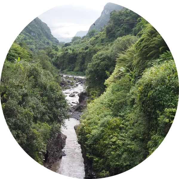
Volcanic environments and mineral landscapes
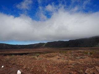
The sequence dedicated to the volcanic zones highlights the physical processes that define the island. The Plaine des Sables appears as an extensive mineral surface, characterized by its uniform textures and subtle variations in colour. The Cratère Commerson introduces a sudden break in the terrain, with steep walls and significant depth, illustrating the impact of collapse phenomena linked to volcanic activity.
The route des laves and the Enclos du Grand Brûlé provide insight into more recent transformations. Successive lava flows have created irregular surfaces where vegetation gradually reappears, demonstrating the slow process of ecological recovery. At Piton Sainte-Rose, the presence of Notre-Dame des Laves offers a striking example of the interaction between built structures and volcanic events, as the church stands within an area reshaped by lava.
Relief, cirques and access routes
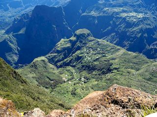
Beyond the volcanic zones, the island is structured by three major cirques: Mafate, Salazie and Cilaos. These large natural amphitheatres result from erosion and collapse processes, forming enclosed spaces with distinct characteristics. Mafate, visible from the Maïdo viewpoint, is marked by its isolation, with no direct road access and a landscape composed of ridges and deep ravines.
Salazie contrasts through its more humid environment, where vegetation is abundant and the relief appears less abrupt. The village of Hell-Bourg illustrates how settlements adapt to these conditions, integrating built structures into the surrounding landscape. In Cilaos, access is defined by a winding mountain road, which reflects the technical challenges of connecting isolated areas. The village itself occupies a relatively open basin within the cirque, showing a different spatial configuration.
Road networks such as the route to Cilaos play a central role in linking these environments. They reveal how infrastructure has been developed to navigate steep terrain and connect dispersed settlements, forming an essential component of the island’s organization.
Urban spaces, markets and everyday life
The video also explores urban areas including Saint-Benoît, Saint-Pierre and Saint-Paul, where economic and social activities are concentrated. Markets in these towns function as focal points for exchange, bringing together local production, trade and daily interactions. In Saint-Pierre and Saint-Paul, these spaces illustrate the integration of commercial activity within the urban fabric.
These towns display a layered organization in which residential areas, commercial zones and public spaces coexist. The diversity of activities reflects a flexible urban structure, shaped by both historical development and contemporary needs. The presence of infrastructure, roads and public spaces highlights the continuity between rural and urban environments.
Religious buildings and cultural plurality
Places of worship form a significant part of the visual and spatial landscape. Hindu temples, such as those of Petit Bazar, Narassigua Péroumal and Siva Supramanian, are characterized by their structured layouts and integrated decorative elements. They reflect the enduring presence of communities of Indian origin and the transmission of religious traditions within the island’s society.
The Atyaboul Massadjid mosque in Saint-Pierre introduces another architectural and cultural dimension, with its large prayer hall and distinctive structural features. Christian churches, including Sainte-Anne, represent yet another layer of religious practice, distributed across the territory in relation to local communities.
The coexistence of these different buildings illustrates a plural religious landscape embedded within both urban and rural contexts. Their distribution and architectural presence contribute to the understanding of how cultural identities are expressed spatially.
Visual clarity through photographic sequencing
The videos on this site offer a specific way of reading landscapes and built environments. By relying largely on carefully selected and animated photographs, they allow for a detailed observation of textures, volumes and spatial relationships. Transitions between sequences highlight the continuity between volcanic formations, inhabited spaces and architectural structures.
This approach makes it possible to examine elements that are often overlooked in faster visual formats, such as the structure of lava flows, the arrangement of settlements within the cirques or the integration of religious buildings into their surroundings. The gradual progression from one site to another helps clarify how different parts of the island relate to each other.
A territory defined by contrasts and continuity
Réunion Island emerges as a territory where contrasts between natural environments and human settlements define its identity. Volcanic activity, relief and cultural diversity interact to produce a complex spatial organization that can be observed through landscapes, infrastructure and architecture.
The video offers a coherent overview of these relationships, linking geological features with everyday life and cultural expression. It provides a structured introduction to the island, while encouraging further exploration through the detailed pages dedicated to its monuments, traditions and natural sites.
Links to related pages
Videos
• Reunion Island •
Audio Commentary Transcript
Time and time again the lava from Piton de la Fournaise has made its way to the ocean, destroying everything in its path.
All...?
There have been historical exceptions such as this church of Sainte Rose which was spared during the dramatic eruption of 1977.
But as always, life takes back its rights even after a major trauma like a lava flow.
The following photos were taken on the RN2 which has been repeatedly cut by lava. The first plants emerge again from the cooled lava after a few years.
March 24 marks the beginning of a catastrophic eruption of Piton de la Fournaise which would last until April 16. The lava flow did not follow the usual course and crossed the village of Piton Sainte Rose twice.
On April 13, the lava flow destroyed thirty houses in the village and spared (miraculously?) The village church.
If some speak of a miracle, how can we explain that the gendarmerie also escaped this destructive flow.
The church was renamed "Notre-Dame des Laves".
The gendarmerie remained "National Gendarmerie" .... but was rebuilt a little further.
But the volcano is not only a source of desolation and destruction ...
It has given birth to a multitude of breathtaking landscapes, creating more magnificent sites than the others.
It is the meeting of fire and water that we owe these extraordinary coastal landscapes, even if they are not to the liking of beach goers.
It is also a very ancient volcanic activity that the cirques of Salazie, Cilaos and Mafate with their steep reliefs and their remarkable waterfalls must exist.
The Bois Court belvedere is a promontory on a very deep valley in the foothills of the Cilaos cirque. The villages at the bottom of the gorge (including the Grand Bassin islet) are several hours' walk from the first shop ... It is therefore better not to forget something when shopping.
Fortunately, a freight elevator system has been put in place to facilitate the provisioning of a few dozen inhabitants.
But Reunion is not just marvelous landscapes shaped by the volcanic activity of the island during the last 100,000 years.
It is also a very warm island with its extremely friendly inhabitants who live in villages full of charm.
History also shaped the island with happy and other more controversial periods such as this episode of slavery which lasted until the end of the 19th century. It is moreover slavery and especially the fierce desire for freedom of the victims (maroon slaves) which is the source of the habitat in the inaccessible circuses of Cilaos and Mafate.
The Cirque de Salazie is home to one of the most beautiful villages in France, Hell Bourg.
Gastronomy is also part of the culture of Reunion with the wonderful spices sold among others on traditional markets ...
Music:
- - YouTube video library - Final Transmission
- - YouTube video library - Flowers in the Rain
- - YouTube video library - Her Owl Ring
- - YouTube video library - Impending Doom Film Trailer
- - YouTube video library - InvestigationMissing Pieces
- - YouTube video library - Invisible Beauty
- - YouTube video library - Light Years Away
- - YouTube video library - Messiah by Haendel
- - YouTube video library - People Watching
- - YouTube video library - Rising Sun
- - YouTube video library - Viking
Disclaimer: Despite its appropriateness, copyright issues prevent the use of reunionese traditional music in "Reunion: the volcano, the landscapes and the people • Reunion Island", hence the use of royalty-free music. Despite our careful selection, some might regret this decision, which is necessary to avoid potential lawsuits. Although difficult, this decision is the only viable solution.