
 Français (France)
  Nederlands (nl-NL)
 The landscapes of Piton de la Fournaise, located on Réunion Island in the Indian Ocean, form one of the most remarkable volcanic environments in the region. This active volcano shapes a territory characterized by extensive lava flows, mineral plains and rugged relief. Frequent eruptions continuously transform the appearance of the area and generate a wide range of geological formations. The environment often presents strong contrasts between dark volcanic rocks and vegetation gradually reclaiming the terrain. These striking panoramas illustrate the ongoing evolution of a volcanic landscape. The site attracts scientists, hikers and visitors interested in observing the natural processes linked to volcanic activity.
Reunion • Landscapes of Piton de la Fournaise
Reunion • Landscapes of Piton de la Fournaise

Reunion • Landscapes of Piton de la Fournaise
Natural site profile
Landscapes of Piton de la Fournaise
Natural site category: Vulcano
Natural site family: Volcanoes and calderas
Natural site genre: Terrestrial
Geographic location: Piton de la Fournaise • Reunion Island
This natural site in Piton de la Fournaise is inscribed on the UNESCO World Heritage List since 2010 and is part of the serial property "Pitons, cirques and remparts of Reunion Island".See the UNESCO natural sites featured on this site
• Links to •
• List of videos about on this site •
Reunion: the volcano, the landscapes and the people • Reunion Island
• References •
UNESCO: Pitons, cirques and remparts of Reunion Island
The Landscapes of Piton de la Fournaise: Historical Valorization, Regional Development and Contemporary Conservation Challenges
A volcanic landscape shaping the identity of Réunion Island
The landscapes surrounding Piton de la Fournaise, located in the southeastern part of Réunion Island near Saint-Pierre, represent one of the most remarkable volcanic environments in the Indian Ocean. The active volcano dominates a vast region characterized by lava fields, basaltic plateaus and rugged relief formed by successive eruptions. Over time, the significance of this landscape has evolved from a natural phenomenon observed with caution to a site valued for its scientific importance, its role in regional identity and its contribution to economic development.
The preservation and recognition of the Piton de la Fournaise landscapes did not emerge suddenly. Instead, they resulted from a gradual process involving political awareness, scientific curiosity, economic interests and cultural appreciation. Each of these factors contributed to shaping the perception and management of the volcanic territory.
Early exploration and the emergence of scientific interest
The first steps toward the recognition of Piton de la Fournaise as a site of importance began during the exploration and early settlement of Réunion Island. In the eighteenth and nineteenth centuries, travelers, administrators and naturalists documented the volcano and its frequent eruptions. These observations attracted the attention of scientists interested in understanding volcanic processes.
During this period, the study of volcanoes became an increasingly important field within the natural sciences. Piton de la Fournaise offered an ideal location for observation because of its accessibility and its regular activity. Scientists began to analyze the formation of lava flows, craters and volcanic cones, transforming the site into a natural laboratory for geological research.
This scientific interest represented one of the earliest motivations for preserving the landscape. Protecting the volcanic terrain ensured continued opportunities for research and improved understanding of the Earth’s internal processes.
Political recognition and territorial significance
As Réunion Island developed administratively and politically, Piton de la Fournaise acquired an additional symbolic role. The volcano became a defining geographical landmark and a powerful element of the island’s identity. Its dramatic eruptions and distinctive landscapes contributed to the perception of Réunion as a territory shaped by natural forces.
Political authorities increasingly recognized the importance of protecting this unique environment. The volcanic region was not only a geological feature but also a cultural symbol representing the island’s natural heritage. This awareness gradually encouraged policies aimed at managing the surrounding landscapes and ensuring their long-term preservation.
Such developments mirrored broader global trends in which remarkable natural sites became central components of national or regional heritage.
Economic motivations and the rise of tourism
During the twentieth century, economic considerations played a growing role in the valorization of the Piton de la Fournaise landscapes. The spectacular nature of the volcanic terrain began to attract visitors interested in witnessing eruptions and exploring lava fields.
The accessibility of the volcano allowed the development of tourism activities such as hiking, guided excursions and geological observation. Infrastructure including roads, viewpoints and trails made it possible for visitors to experience the volcanic landscape in relatively safe conditions.
Tourism soon became an important economic asset for Réunion Island. The Piton de la Fournaise region emerged as one of the island’s most recognizable attractions, strengthening the link between environmental preservation and economic development. Protecting the volcanic environment thus became essential not only for ecological reasons but also for maintaining a valuable tourism resource.
Global context and comparisons with other volcanic landscapes
The recognition and protection of Piton de la Fournaise reflect wider global developments in the management of volcanic landscapes. Throughout the twentieth century, societies increasingly acknowledged the importance of preserving exceptional geological environments.
Volcanic regions such as Mount Etna in Italy, the volcanoes of Hawaii and Iceland’s volcanic fields experienced similar processes of scientific study, tourism development and environmental protection. In each of these cases, volcanic activity was transformed from a perceived hazard into an element of natural heritage and scientific value.
The case of Piton de la Fournaise illustrates how local landscapes can gain international significance when they contribute to the global understanding of geological phenomena.
Transformations of the volcanic landscape over time
Unlike many natural landscapes, the terrain around Piton de la Fournaise changes continuously. Frequent eruptions create new lava flows that reshape the terrain and alter the appearance of the surrounding environment. Some eruptions extend lava flows toward the ocean, creating new coastal formations.
Over time, older lava fields gradually undergo ecological transformation. Weathering processes break down the basaltic rock, allowing vegetation to colonize the surface. This slow ecological succession transforms barren volcanic terrain into habitats capable of supporting diverse plant communities.
These transformations illustrate the dynamic nature of volcanic landscapes and highlight the ongoing interaction between geological forces and biological processes.
Contemporary preservation and environmental management
Today, the landscapes of Piton de la Fournaise are part of a broader protected natural area that recognizes their ecological and geological significance. Conservation policies aim to balance several objectives: preserving fragile ecosystems, facilitating scientific research and allowing controlled public access.
The management of the volcanic environment involves monitoring volcanic activity, maintaining safe visitor routes and protecting sensitive ecological zones. These efforts seek to ensure that the natural processes shaping the landscape continue without excessive human disturbance.
International recognition of the volcanic landscapes of Réunion has also strengthened awareness of their global importance as a site where geological processes can be studied and appreciated.
Modern challenges to long-term preservation
Despite these conservation measures, the Piton de la Fournaise region faces several challenges in the modern era. One of the most significant pressures comes from increasing tourism. While visitor access contributes to the local economy, it also raises concerns about environmental degradation and the disturbance of fragile ecosystems.
Managing visitor numbers and infrastructure development is therefore essential to maintaining the balance between accessibility and conservation. Authorities must ensure that tourism activities do not compromise the natural processes that make the volcanic landscape unique.
Climate change represents another long-term challenge. Changes in rainfall patterns and temperature may affect vegetation dynamics and erosion processes on the volcanic slopes. Although the volcanic activity itself is governed by deep geological mechanisms, the ecosystems surrounding the volcano remain sensitive to environmental change.
Conclusion
The landscapes of Piton de la Fournaise illustrate how a volcanic environment can evolve from a dramatic natural phenomenon into a protected and internationally recognized natural heritage site. Scientific exploration, political recognition, economic development and cultural appreciation have all contributed to the gradual valorization of this remarkable region.
Today, the preservation of Piton de la Fournaise requires a careful balance between scientific research, tourism and environmental protection. Maintaining this balance will be essential to ensure that future generations can continue to observe one of the world’s most active and instructive volcanic landscapes.
The Landscapes of Piton de la Fournaise: Geological Processes, Ecological Evolution and Global Significance
A volcanic landscape shaped by deep geological forces
The landscapes of Piton de la Fournaise, located on Réunion Island in the Indian Ocean, provide a striking example of the geological processes that create and transform volcanic islands. The volcano is one of the most active basaltic volcanoes on Earth and plays a central role in the formation of the island’s southeastern region. Its activity illustrates how magma rising from deep within the Earth can build landforms through successive eruptions.
The volcanic massif is characterized by extensive lava fields, craters, fissures and volcanic cones formed by repeated eruptions over thousands of years. These features reveal the ongoing interaction between molten rock, atmospheric conditions and the surrounding terrain. Because eruptions occur relatively frequently, scientists can observe the formation of new geological structures in real time. This dynamic environment offers a rare opportunity to study the evolution of volcanic landscapes as they develop and transform.
Topography and the structure of a shield volcano
Piton de la Fournaise is a classic example of a shield volcano, a type of volcanic structure formed by successive flows of fluid basaltic lava. Unlike steep stratovolcanoes, shield volcanoes are characterized by broad, gently sloping flanks that extend over large areas.
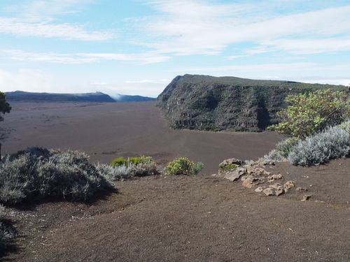
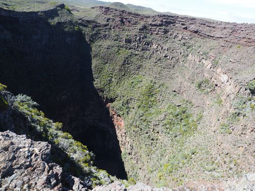
The volcano rises to an elevation of more than 2,600 meters and dominates a vast depression known as the Enclos, a natural caldera created by ancient collapses of the volcanic structure. The steep walls surrounding this depression form dramatic escarpments that separate the active volcanic zone from the rest of the island.
Within the Enclos, numerous lava flows spread across a landscape that appears both stark and varied. Some surfaces display smooth, rope-like formations created by slowly moving lava, while others consist of rough and fragmented blocks formed by rapid cooling. These contrasting textures demonstrate how variations in temperature, gas content and eruption intensity influence the shape of volcanic terrain.
Lava flows and volcanic formations
The frequent eruptions of Piton de la Fournaise produce extensive lava flows that reshape the landscape with remarkable speed. Some flows advance gradually across the volcanic plains, while others follow natural channels toward the coast. In certain cases, lava reaches the ocean, where it cools rapidly and creates new coastal formations.
One of the most fascinating geological features associated with basaltic eruptions is the formation of lava tubes. These natural tunnels develop when the outer layer of a lava flow solidifies while molten lava continues to move beneath the surface. Once the eruption ends and the lava drains away, hollow tunnels remain within the rock.
These formations provide valuable insight into the behavior of flowing lava and have become important sites for geological study. Similar lava tube systems are found in other volcanic regions around the world, but the accessibility and activity of Piton de la Fournaise make it particularly valuable for research.
Biological colonization of volcanic terrain
Although freshly solidified lava initially appears lifeless, the volcanic landscapes of Piton de la Fournaise gradually become the stage for a remarkable ecological transformation. Over time, pioneering organisms begin to colonize the barren rock.
Lichens, mosses and certain resilient plant species are among the first living organisms capable of surviving in this harsh environment. These pioneer species slowly break down the volcanic rock and contribute to the formation of thin layers of soil. As these soils develop, additional plants begin to grow, creating a process known as ecological succession.
The gradual colonization of lava flows illustrates how life adapts to extreme environments. Within decades or centuries, areas once covered by molten rock can evolve into ecosystems supporting grasses, shrubs and small forests.
Biodiversity shaped by isolation and climate
Réunion Island’s isolation in the Indian Ocean has allowed the development of a distinctive biological environment. Many plant and animal species found on the island are endemic, meaning they occur nowhere else in the world.
The volcanic landscapes surrounding Piton de la Fournaise host ecosystems adapted to challenging conditions such as strong winds, variable temperatures and mineral-rich but nutrient-poor soils. Vegetation in the higher volcanic zones often consists of hardy species capable of surviving in thin soils and exposed environments.
In older lava fields where soil development has progressed further, vegetation becomes more diverse. These areas support a variety of plant communities that reflect the gradual transformation of volcanic terrain into fertile landscapes.
Interactions between local geology and global environmental processes
The formation and evolution of Piton de la Fournaise are closely linked to global geological processes. The island itself owes its existence to a volcanic hotspot located beneath the oceanic crust. This hotspot continuously supplies magma that feeds the volcano and drives its eruptions.
At the same time, the local environment is influenced by broader climatic systems. Réunion lies in a tropical region where rainfall patterns are shaped by trade winds and occasional cyclones. These climatic conditions affect erosion rates, vegetation growth and the pace at which volcanic rock breaks down into soil.
The interaction between geological activity and climatic influences demonstrates how local landscapes can reflect both regional and global environmental dynamics.
International recognition and scientific importance
The remarkable geological and ecological features of Piton de la Fournaise have contributed to its international recognition as a site of exceptional natural value. The volcano forms part of a larger mountainous landscape that includes dramatic cirques and steep volcanic ramparts.
This broader volcanic environment has been recognized internationally for its outstanding natural significance. The recognition highlights the importance of protecting landscapes where geological processes can still be observed in action.
International attention has also strengthened conservation policies and scientific monitoring of the volcano. Continuous observation of eruptions provides valuable information for volcanology and contributes to global research on volcanic activity.
Conservation and environmental management
Today the landscapes of Piton de la Fournaise are carefully managed to balance environmental protection, scientific research and public access. Monitoring stations track volcanic activity and help ensure the safety of visitors and nearby communities.
The management of the area also seeks to protect fragile ecosystems that have developed on older lava fields. By regulating visitor access and maintaining designated trails, authorities aim to prevent damage to sensitive habitats.
These conservation efforts reflect a growing awareness of the importance of preserving geological heritage sites where natural processes remain active.
Conclusion
The landscapes of Piton de la Fournaise provide an exceptional illustration of the dynamic forces that shape volcanic islands. Geological processes, lava flows and ecological succession combine to create a constantly evolving environment that reveals the interaction between the Earth’s interior and the surface ecosystems.
This unique combination of geological activity and biological adaptation has made the volcano one of the most important natural laboratories for the study of volcanic processes. Its international recognition underscores the importance of protecting such landscapes, ensuring that they continue to offer insight into the powerful natural forces that shape our planet.