
 Français (France)
  Nederlands (nl-NL)
 Located in Melli at the border of Sikkim, this area marks the transition between the plains of West Bengal and the first Himalayan slopes. The landscape is defined by a steep valley, a river crossed by a bridge, and roads that follow the constraints of the terrain. Mountain routes are essential for access to the region, while also illustrating the challenges of maintaining and upgrading infrastructure. The presence of control points and steady traffic flows highlights the strategic role of this crossing, both as a geographical boundary and an administrative entry point.
Melli •
Melli •
Melli •
Natural site profile
Natural site category: Mountain roads
Natural site family: Mountains and hills
Natural site genre: Terrestrial
Geographic location: Melli • Sikkim • India
• Links to •
• List of videos about Melli on this site •
Sikkim • Beyond the border • India
Landscapes and roads at the Sikkim border: evolution of a Himalayan transit corridor
Origins and early functions
The area around Melli, at the border of Sikkim, has long served as a point of transition between the plains of eastern India and the Himalayan foothills. Before its integration into India, Sikkim functioned as an independent kingdom with controlled access points. Movement across this boundary relied on limited routes adapted to difficult terrain, facilitating trade, administrative contact, and cultural exchange. Melli gradually emerged as a key crossing location due to its position along a valley that naturally channels movement between contrasting environments.
Establishment of infrastructure and territorial control
The incorporation of Sikkim into the Indian Union in 1975 marked a turning point in the organization of access routes. The border at Melli became an administrative checkpoint, regulating the movement of people and goods. Road development was driven by several objectives, including territorial integration, improved connectivity, and administrative oversight. As a result, mountain roads became the primary means of access, linking Sikkim with surrounding regions and reinforcing the strategic importance of this entry point.
Phases of road development
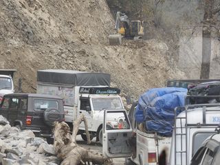
Over time, the road network connecting Sikkim to West Bengal underwent successive phases of expansion and reinforcement. Early routes were progressively widened and adapted to motorized traffic, although the process has remained incomplete due to environmental constraints. Landslides, seasonal rainfall, and slope instability have required continuous intervention. The ongoing roadworks visible today reflect this long-term pattern of adjustment rather than a temporary phase, illustrating the need for sustained infrastructure management in a mountainous context.
Regional impact and economic evolution
The improvement of access routes through Melli has significantly influenced regional dynamics. Enhanced connectivity has facilitated trade, mobility, and administrative integration, contributing to the economic development of Sikkim. At the same time, the presence of border controls has maintained a level of regulation over these flows, highlighting the dual function of the site as both a gateway and a checkpoint. The area has thus evolved into a structured corridor where circulation is both enabled and supervised.
Transformation of landscape and uses
The expansion and maintenance of roads have led to visible changes in the surrounding landscape. Earthworks, slope stabilization measures, and construction zones have modified the terrain, reflecting an ongoing interaction between natural constraints and technical solutions. The area is characterized by a constant state of adaptation, where infrastructure responds to environmental pressures while shaping patterns of movement and settlement. Daily uses of the site, including transit, waiting, and local mobility, are closely linked to these evolving conditions.
Present-day significance
Today, Melli remains one of the main land entry points into Sikkim. Its role extends beyond simple transit, functioning as a critical link in the region’s territorial continuity. The concentration of traffic and the presence of administrative facilities reinforce its importance within both regional and national networks. The site provides a clear illustration of how mountainous border areas operate as structured interfaces between different geographical and administrative systems.
Contemporary management and conservation challenges
The primary challenges associated with this area relate to the maintenance of infrastructure in an unstable environment. Road safety, erosion control, and the management of natural risks require continuous attention. Balancing development with environmental stability remains a complex issue, particularly in a context where technical interventions can alter natural processes. The Melli border zone exemplifies the tensions inherent in mountain regions, where accessibility, safety, and environmental considerations must be managed simultaneously.
Landscapes and mountain roads at the Sikkim border: physical characteristics and spatial organization
Relief and spatial structure
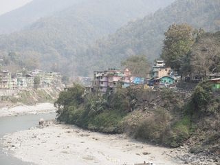
The area around Melli marks a transition zone between the lowlands of West Bengal and the first Himalayan foothills. The terrain is defined by steep slopes, narrow valleys, and a fragmented topography shaped by river erosion. The Teesta River, flowing at the base of the valley, forms a central axis that structures both the landscape and human circulation. Settlements and infrastructure occupy limited flat surfaces or terraces carved into the slopes, creating a layered spatial organization where vertical differences dominate perception.
Geological context and slope dynamics
The region belongs to the outer Himalayan belt, composed of relatively young geological formations. The rocks are often fractured and unstable, contributing to frequent slope movements. Weathering processes, combined with intense seasonal rainfall, accelerate erosion and landslides. Exposed soil surfaces, retaining walls, and temporary stabilization structures are visible along the roads, reflecting ongoing efforts to manage these natural constraints. The terrain is in constant adjustment, with visible traces of both natural processes and human intervention.
River system and hydrological features
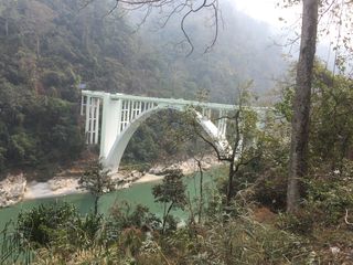
The Teesta River plays a central role in shaping the local environment. Its course through the valley creates steep banks and a confined channel, with strong currents during the monsoon season. Smaller streams descend from the surrounding slopes, feeding into the main river and contributing to the overall drainage system. Bridges spanning the river provide critical connections between the two sides of the valley, often positioned at narrow crossing points where the topography allows construction. The presence of water reinforces the contrast between the lower valley floor and the elevated road network.
Vegetation and ecological environment
The slopes are covered with dense subtropical and lower montane vegetation, including mixed forests, shrubs, and cultivated areas. The distribution of vegetation reflects both altitude and exposure, with thicker growth in humid zones and more open areas where construction or erosion has altered the surface. Agricultural terraces can be observed in certain sections, indicating human adaptation to the terrain. The vegetation contributes to slope stabilization but is also affected by road construction and earthworks, which locally reduce plant cover.
Fauna and environmental conditions
Although not always directly visible, the region supports a range of animal species adapted to forested mountain environments. Birds are among the most observable elements, particularly in areas with less disturbance. The broader ecosystem includes small mammals and reptiles, whose presence is linked to forest continuity and water availability. Human activity, especially along major roads, creates a fragmented environment where wildlife distribution is influenced by infrastructure and traffic intensity.
Road infrastructure and circulation patterns
Mountain roads constitute the most prominent human feature in the landscape. They follow the natural contours of the slopes, forming winding routes with sharp turns and variable gradients. The roadway is often carved directly into the hillside, with protective barriers or retaining walls in sections exposed to erosion. Construction zones are common, with heavy machinery, temporary diversions, and traffic queues indicating continuous maintenance and upgrading efforts. The road network is both functional and fragile, shaped by the need to balance accessibility with environmental constraints.
Visual experience and landscape perception
The visual structure of the site is defined by contrasts in scale and elevation. From the road, views alternate between close-up perspectives of rock faces and vegetation, and wider panoramas over the valley and river below. The presence of bridges, vehicles, and construction activity introduces dynamic elements into an otherwise natural setting. Movement through the area reveals successive layers of the landscape, where each bend in the road modifies the field of view. The combination of natural relief and engineered structures creates a spatial experience dominated by depth, height, and continuous variation.
Distinctive characteristics of the site
What distinguishes this area is the direct interaction between a demanding natural environment and an evolving transport network. The landscape is not static; it reflects ongoing processes of adaptation, where roads, slopes, and vegetation are constantly reshaped. The coexistence of active construction, constrained circulation, and complex terrain provides a clear illustration of how mountain environments are negotiated in practical terms. The site offers a concentrated example of Himalayan foothill conditions, where relief, water systems, and infrastructure combine to define both the physical setting and its daily use.