
 Français (France)
  Nederlands (nl-NL)
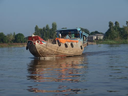
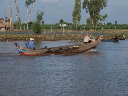
 The Mekong River between Chau Doc and Phnom Penh represents one of the most characteristic stretches of this major Southeast Asian waterway. In this part of Cambodia the river flows through an extensive alluvial plain marked by side channels, cultivated land and numerous riverside communities. River transport remains an important means of movement and trade in the region. The landscape alternates between wide water surfaces, sandy banks and tropical vegetation. This section of the river illustrates the interaction between human activities, fluvial navigation and natural environments that shape daily life along the lower Mekong basin.

Natural site profile
Mekong in Cambodia
Natural site category: River
Natural site family: Seas, lakes and rivers
Natural site genre: Aquatic
Geographic location: Mekong de Chau Doc à Phnom Penh • Cambodia
• Links to •
• List of videos about Mekong de Chau Doc à Phnom Penh on this site •
Cambodia • On the Mekong
The Mekong between Chau Doc and Phnom Penh: Historical Dynamics, Regional Development and Contemporary Preservation Challenges
The section of the Mekong River extending from Chau Doc to Phnom Penh represents a significant natural corridor within mainland Southeast Asia. Over centuries, this part of the river has shaped regional settlement patterns, economic networks and ecological systems. Its preservation and gradual valorization have not resulted from a single historical initiative but from a long sequence of political, economic and cultural developments. These processes reflect broader regional transformations and mirror global trends in the management of major river systems.
Early historical significance and cultural relationships with the river
Long before formal conservation policies existed, the Mekong played a central role in the lives of communities inhabiting its banks. The fertile floodplains supported agriculture, fishing and river-based trade, making the river an essential economic artery. Settlements developed along navigable sections of the river, including the area between present-day Chau Doc and Phnom Penh, which served as an important connection between the Mekong Delta and the inland territories of Cambodia.
Local populations developed cultural practices closely tied to the river’s seasonal cycles. Annual floods replenished soils and supported agricultural productivity, reinforcing a perception of the river as both a life-giving natural force and a central element of regional identity. This cultural relationship indirectly contributed to the long-term preservation of many floodplain ecosystems, as traditional livelihoods depended on maintaining the river’s natural rhythms.
Colonial exploration and the emergence of economic infrastructure
A new phase in the transformation of the river began during the nineteenth century with the arrival of European colonial powers in Southeast Asia. French colonial authorities viewed the Mekong as a potential commercial route linking the interior of the Indochinese peninsula with international maritime trade.
Exploratory expeditions and river surveys attempted to determine whether the Mekong could serve as a major transport corridor between China and the South China Sea. Although the river’s complex hydrology ultimately limited its use as a continuous navigation route, these efforts increased international attention toward the lower Mekong basin.
Colonial administration also introduced new economic activities, including plantation agriculture and expanded river trade. Ports and administrative centers grew along the riverbanks, reinforcing the strategic importance of the section between Chau Doc and Phnom Penh.
Twentieth-century political changes and regional development
The twentieth century brought major political transformations that influenced the management of the Mekong and its surrounding landscapes. The decline of colonial rule and the emergence of independent states in Southeast Asia led to new approaches to river governance.
During the Cold War period, the Mekong basin became the focus of ambitious development plans. International initiatives promoted large-scale infrastructure projects intended to modernize agriculture, regulate water flows and expand regional electricity production. These proposals were often inspired by global models of river management that had transformed major waterways such as the Tennessee River in the United States or the Rhine in Europe.
Although not all projects were implemented, the planning process itself contributed to a broader understanding of the ecological importance of the Mekong system. Scientific studies and international cooperation began to emphasize the need to balance economic development with environmental sustainability.
Recognition of ecological value and emerging conservation concerns
By the late twentieth century, researchers increasingly recognized the Mekong as one of the most biologically diverse river systems in the world. The floodplains between Chau Doc and Phnom Penh were identified as critical habitats for fish migration, wetland ecosystems and riverine biodiversity.
This growing awareness contributed to the emergence of regional and international efforts aimed at monitoring environmental change in the Mekong basin. Governments, research institutions and international organizations began to promote more coordinated approaches to water management.
In parallel, the rise of environmental movements worldwide encouraged greater attention to river ecosystems. Similar debates were taking place along other major rivers such as the Amazon, the Nile and the Danube, where economic development projects raised questions about ecological preservation.
Transformations of the landscape and river system
The Mekong landscape has undergone significant changes over the centuries. Natural processes such as sediment deposition and seasonal flooding have continuously reshaped the riverbanks and floodplains. These processes created a mosaic of wetlands, agricultural lands and river channels that define the region today.
Human activities have also contributed to transforming the environment. Agricultural expansion has altered parts of the floodplain, while urban growth near Phnom Penh has introduced new pressures on surrounding ecosystems. Navigation channels, irrigation systems and transport infrastructure have further modified the river’s immediate landscape.
Despite these transformations, large portions of the floodplain continue to function as seasonal wetlands that support fisheries and agriculture. The persistence of these natural cycles remains essential to the ecological balance of the region.
Global context and comparisons with other major river systems
The history of the Mekong between Chau Doc and Phnom Penh reflects broader global patterns in river management. Throughout the twentieth century, many countries pursued large-scale river engineering projects to support economic growth.
In Europe, rivers such as the Rhine were heavily modified to improve navigation and prevent flooding. In North America, extensive dam systems transformed the Colorado and Columbia rivers. In South America, development projects along the Amazon raised similar questions about the balance between economic development and environmental protection.
Compared with these examples, the Mekong has retained relatively large sections of its natural floodplain dynamics. This characteristic makes the river system particularly valuable for ecological research and biodiversity conservation.
Current state of preservation
Today, the section of the Mekong between Chau Doc and Phnom Penh remains a vital ecological and economic landscape. Fisheries continue to provide food and income for millions of people, while agriculture benefits from the nutrient-rich sediments deposited during annual floods.
At the same time, growing awareness of environmental sustainability has encouraged governments and international organizations to promote more responsible water management practices. Regional cooperation initiatives aim to improve scientific understanding of the river and support policies that maintain ecological balance.
Tourism and cultural interest in the Mekong landscape have also contributed to its recognition as a distinctive natural environment within Southeast Asia.
Contemporary challenges and future prospects
Despite these efforts, the Mekong faces significant challenges in the twenty-first century. Rapid economic development, population growth and infrastructure projects are placing increasing pressure on river ecosystems.
Hydropower development in upstream regions has become one of the most debated issues affecting the future of the Mekong basin. Changes in sediment transport and water flow patterns may influence downstream ecosystems and fisheries.
Climate change represents another important factor. Alterations in rainfall patterns and rising temperatures may affect the seasonal flooding cycle that sustains the floodplain ecosystems between Chau Doc and Phnom Penh.
Addressing these challenges requires cooperation between the countries that share the Mekong basin. Long-term preservation will depend on balancing economic development with the protection of one of the world’s most productive river ecosystems.
Conclusion
The Mekong between Chau Doc and Phnom Penh illustrates how natural landscapes evolve through the interaction of environmental processes, political decisions and economic priorities. From traditional river-based societies to modern environmental awareness, each historical phase has contributed to shaping the significance of this river corridor. The future of the region will depend on the ability of local and international actors to preserve the ecological dynamics that have sustained human communities along the Mekong for centuries.
Natural Dynamics of the Mekong between Chau Doc and Phnom Penh: Geology, Biodiversity and Ecological Processes in a Major Southeast Asian River System
The stretch of the Mekong River between Chau Doc in southern Vietnam and Phnom Penh in Cambodia forms one of the most dynamic river landscapes in Southeast Asia. This section lies within the lower Mekong basin, where geological processes, seasonal hydrology and biological diversity combine to produce a complex and productive ecosystem. Over thousands of years, the interaction between sediment transport, flood cycles and ecological adaptation has shaped a landscape that illustrates the functioning of large tropical river systems. The natural characteristics of this region provide a clear example of how geology, climate and biodiversity interact within one of the world’s major river basins.
Geological formation and the development of the floodplain
The geological history of the lower Mekong basin is closely linked to long-term sediment transport from upstream regions. The Mekong originates in the Tibetan Plateau and travels more than 4,000 kilometers before reaching the lowlands of Cambodia and Vietnam. During this journey, the river carries enormous quantities of sand, clay and silt eroded from mountain ranges in China, Laos and northern Thailand.
When the river reaches the relatively flat terrain of Cambodia, the speed of the current decreases and much of this sediment begins to accumulate. Over thousands of years, these deposits have created a vast alluvial plain extending along the lower Mekong. The stretch between Chau Doc and Phnom Penh lies within this sedimentary landscape.
The topography of the region is therefore dominated by low elevations and broad floodplains rather than steep relief. Natural levees formed by sediment deposition run parallel to the riverbanks, while shallow basins extend inland from the main channel. These features influence water distribution during seasonal floods and contribute to the creation of wetlands and temporary lakes.
Seasonal hydrology and the flood pulse system
One of the most distinctive ecological processes in this part of the Mekong is the seasonal flood cycle driven by the Southeast Asian monsoon. During the rainy season, heavy precipitation across the basin dramatically increases the volume of water flowing downstream.
This annual rise in water levels causes the river to overflow its banks and inundate surrounding floodplains. The resulting expansion of water across agricultural lands and wetlands creates what scientists often describe as a “flood pulse” system. Instead of being a destructive force, the flood acts as a key ecological driver that replenishes soils and supports biological productivity.
When floodwaters spread across the plains, they deposit nutrient-rich sediments that enhance soil fertility. As water levels decline during the dry season, these nutrients support agriculture and plant growth. This natural fertilization process has sustained farming communities in the region for centuries.
A corridor of exceptional aquatic biodiversity
The Mekong basin is widely recognized as one of the most biodiverse river systems in the world. The section between Chau Doc and Phnom Penh plays an important role within this ecological network because it functions as a migration corridor and feeding ground for numerous aquatic species.
Scientists estimate that the Mekong supports more than 1,100 species of freshwater fish, making it second only to the Amazon River in terms of fish diversity. Many of these species depend on seasonal migration patterns that are closely linked to the flood cycle.
During periods of high water, fish move into flooded forests and wetlands where food resources become abundant. These temporary habitats provide ideal conditions for breeding and growth. As water levels decline, fish return to the main river channel, completing an ecological cycle that repeats each year.
Large species such as giant freshwater catfish and giant barb have historically inhabited the Mekong basin, illustrating the ecological richness of the system. Although some populations have declined in recent decades, the river still supports an extraordinary range of aquatic life.
Wetlands, vegetation and ecological interactions
The floodplain between Chau Doc and Phnom Penh contains a mosaic of habitats including river channels, seasonal wetlands, marshes and riparian forests. This diversity of environments supports a wide range of plant and animal species.
Flooded forests are particularly important ecological zones. Trees adapted to periodic inundation provide shelter for fish during the wet season and nesting sites for birds when waters recede. Aquatic vegetation also contributes to stabilizing sediments and maintaining water quality.
Birdlife is abundant in the wetlands surrounding the river. Herons, egrets, storks and other waterbirds use these habitats for feeding and breeding. Reptiles and amphibians are also common, reflecting the ecological richness of the floodplain ecosystem.
These biological interactions illustrate how geological and hydrological processes shape the distribution of life within the river system.
Influence of regional and global environmental processes
Although the ecological characteristics of the Mekong are rooted in local geography, they are also influenced by broader environmental factors. The monsoon climate that governs seasonal rainfall is part of a large atmospheric circulation system affecting much of Asia.
Changes in global climate patterns can influence the intensity and timing of monsoon rainfall. Variations in temperature and precipitation across the Mekong basin may therefore alter the river’s flow regime.
Sediment transport is also affected by geological processes occurring far upstream. Mountain erosion, tectonic activity and land use changes in other parts of the basin all influence the composition and volume of sediments reaching the lower Mekong.
These connections demonstrate how the landscape between Chau Doc and Phnom Penh reflects both local environmental conditions and broader global processes.
International scientific interest and ecological significance
The ecological complexity of the Mekong basin has attracted significant international scientific attention. Researchers study the river’s hydrology, fisheries and wetland ecosystems in order to better understand how large tropical rivers function.
This growing body of research has highlighted the Mekong’s importance for food security, biodiversity conservation and regional environmental stability. Millions of people depend on fisheries and agriculture linked to the river’s seasonal flooding.
Although the stretch between Chau Doc and Phnom Penh is not individually listed as a UNESCO World Heritage site, the ecological importance of the wider Mekong basin has been widely recognized in international conservation discussions. The river is frequently cited as one of the world’s most productive inland fisheries and one of the most biologically diverse freshwater systems.
Contemporary environmental challenges
Despite its ecological richness, the Mekong system faces increasing environmental pressures. Rapid population growth, expanding agriculture and urban development are altering parts of the floodplain landscape.
Hydropower development in upstream regions has become a major issue affecting the future of the river. Dams may modify natural flow patterns and reduce sediment transport, potentially affecting downstream ecosystems and agricultural productivity.
Climate change also introduces uncertainties regarding rainfall patterns and flood cycles. Alterations in seasonal water levels could influence fish migration routes and wetland habitats.
These challenges highlight the importance of cooperative river management across national boundaries, as the Mekong basin is shared by multiple countries.
Conclusion
The section of the Mekong River between Chau Doc and Phnom Penh illustrates the remarkable complexity of large tropical river systems. Geological sedimentation, seasonal flooding and ecological adaptation combine to create one of the most productive and biodiverse freshwater environments in the world.
Its floodplain landscapes, rich fisheries and dynamic hydrological cycles demonstrate how natural processes operate across multiple scales, from local wetlands to regional climate systems. Understanding these interactions is essential for preserving the ecological integrity of the Mekong and ensuring the long-term sustainability of the communities that depend on its waters.