

 Français (France)
  Nederlands (nl-NL)
 Of Hindu tradition, (with additional Buddhist and Jain influence), the Kakatiya dynasty ruled for approximately 323 years, ± between 1000 and 1323 over all or part of Central India, South India and West India, during the Medieval Period.
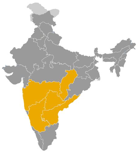
This map illustrates the maximum territory that the Kakatiya Dynasty had reached at its height, covering the current regions of Andhra Pradesh, Chhattisgarh, Karnataka, Maharashtra and Telangana in India. Its main purpose is to provide a visual aid to understand the geographical extent of this dynasty. However, it's important to note that the contemporary borders of these regions may not necessarily coincide with the historical territories.
The Kakatiya dynasty in medieval Indian history and the Telugu world
A regional kingdom formed from the political order of the Deccan
The Kakatiya dynasty held an important place in the history of southern India and the Deccan between the eleventh and early fourteenth centuries. Its rise began in the context of dependence on the Western Chalukyas, under whom the early Kakatiyas acted as feudatory chiefs. Over time, this regional lineage transformed itself into an independent monarchy centred first on Anumakonda and later on Orugallu, the city now known as Warangal.
The historical importance of the Kakatiyas lies in this transformation from subordinate military chiefs into sovereign rulers. Their kingdom developed in the Telugu speaking regions of present day Telangana and Andhra Pradesh, and helped give political expression to a regional identity that would remain significant long after the fall of the dynasty. By the twelfth century, especially under Rudradeva, the Kakatiyas had emerged as a major power able to compete with other dynasties of the Deccan and southern India.
Warangal as a political and military centre
Warangal became the central symbol of Kakatiya authority. The city was not only a capital, but also a fortified political centre, a military stronghold and an administrative hub. Its successive walls, gateways and ceremonial spaces expressed the ambition of a dynasty that sought to organise power around a stable royal seat.
From Warangal, the Kakatiyas controlled routes across the Telugu plateau and maintained connections with the eastern coast. This position allowed them to link inland agrarian regions with commercial routes leading toward coastal Andhra. The city therefore served as a point of coordination between military power, taxation, trade and royal ritual.
The kingdom did not function as a rigidly centralised state in the modern sense. Like many medieval Indian polities, it depended on networks of local chiefs, military officers, landed elites and temple institutions. The Kakatiya rulers had to balance royal authority with regional cooperation. Their success came from their ability to integrate local power holders into a broader political structure centred on Warangal.
Political relations with neighbouring powers
The Kakatiyas played a major role in the political balance of the Deccan. Their neighbours included the Yadavas of Devagiri, the Hoysalas, the later Cholas, the Pandyas and several regional powers of the Andhra and Telangana areas. Their position between the Deccan plateau and the eastern coast made them strategically important.
Under Ganapatideva, the Kakatiya kingdom reached its greatest territorial extent. His reign strengthened control over much of the Telugu country and extended influence toward the coastal regions. This expansion increased the dynasty’s political weight, but also brought it into closer contact and rivalry with neighbouring states.
The final phase of Kakatiya history was shaped by confrontation with the Delhi Sultanate. At the end of the thirteenth and beginning of the fourteenth century, the expansion of northern Indian power into the Deccan changed the political landscape. Prataparudra II faced repeated campaigns, tribute demands and finally the conquest of Warangal in 1323. The fall of the Kakatiya kingdom marked a major stage in the extension of Delhi’s influence into the south.
Architectural and cultural achievements
The cultural impact of the Kakatiyas was considerable. Their period is associated with a distinctive architectural style visible in temples, fortifications, gateways, sculpted pillars, mandapas and water structures. The Rudreshwara Temple at Palampet, commonly known as the Ramappa Temple, is one of the finest monuments connected with Kakatiya patronage. Its refined sculpture, balanced proportions and technical sophistication illustrate the artistic vitality of the period.
Kakatiya architecture was closely linked to the landscape of the Deccan plateau. Temples, tanks and forts were not isolated monuments. They helped organise territory, display royal legitimacy and anchor local communities within the political order of the kingdom. Religious patronage, mainly directed toward Hindu institutions, allowed the rulers to associate themselves with regional sacred traditions while presenting themselves as independent kings.
Rudrama Devi occupies a special place in this cultural and political memory. As a ruling queen who adopted masculine royal titulature, she defended the kingdom and maintained dynastic authority in a political environment dominated by male rulers. Her reign remains one of the most distinctive episodes in medieval South Indian history.
Agriculture, irrigation and economic organisation
The Kakatiya economy was based primarily on agriculture, land revenue, irrigation and internal trade. The dynasty placed great importance on tanks, reservoirs and hydraulic works, which were essential in a region dependent on seasonal rainfall. These systems supported cultivation, stabilised rural production and increased the resources available to the state.
Agricultural expansion strengthened royal revenue and supported temples, urban centres and armies. Market dues, commercial taxes and donations to religious institutions also formed part of the economic system. By controlling routes between inland Telangana and the coastal Andhra regions, the Kakatiyas benefited from the movement of goods, people and revenue across a broad regional network.
Their economic role was therefore not limited to taxation. They contributed to the shaping of a productive landscape in which water management, settlement, temple patronage and trade were closely connected.
A lasting legacy in Telangana and southern India
The Kakatiya dynasty remains central to the historical memory of Telangana and the wider Telugu world. Its legacy survives in Warangal, in the Ramappa Temple, in ancient reservoirs, in fortifications and in traditions associated with Rudrama Devi and Prataparudra II.
The Kakatiyas represent one of the major regional powers of medieval India. Their importance lies in their political consolidation of the Telugu region, their architectural achievements, their management of agrarian resources and their role in the Deccan before the expansion of the Delhi Sultanate. Their history shows how a regional lineage could transform itself into a strong kingdom, shape a cultural landscape and leave a durable mark on southern Indian identity.
The geographical extent of the Kakatiya dynasty between Telangana, Andhra and the Deccan
A regional power rooted in the Telugu plateau
The Kakatiya dynasty developed in the eastern Deccan, mainly in the regions corresponding to present day Telangana and parts of Andhra Pradesh. Its earliest rulers were linked to the Western Chalukyas and initially controlled a limited territory around Anumakonda, near present day Hanamkonda. During this early phase, the Kakatiyas were not yet independent monarchs, but feudatory chiefs whose authority depended on a larger Deccan political order.
From the twelfth century onward, the dynasty gradually asserted its autonomy. This political transformation was accompanied by territorial expansion. The Kakatiyas moved from local power to regional kingship, and their centre of gravity shifted toward Orugallu, later known as Warangal. This city became the capital, the military core and the symbolic centre of the kingdom.
Warangal as the centre of territorial control
Warangal occupied a strategic position in the heart of the Telugu speaking plateau. From this centre, the Kakatiyas could control routes linking inland Telangana with the coastal plains of Andhra. The city’s fortifications, gateways and planned spaces reflected the ambition of a dynasty seeking to organise a durable regional kingdom.
The core areas of Kakatiya authority included Warangal, Hanamkonda, Karimnagar, Nalgonda and neighbouring parts of the Telangana plateau. Their rule, however, should not be understood according to modern administrative borders. Like many medieval Indian kingdoms, the Kakatiya state combined direct administration, local chiefs, tribute relations, military garrisons and negotiated loyalty.
This flexible system allowed the dynasty to extend influence over a broad region without imposing identical control everywhere. Forts, agricultural settlements, reservoirs, temple centres and market towns formed the practical anchors of Kakatiya authority.
Expansion toward coastal Andhra
Under Ganapatideva, the Kakatiya kingdom reached its greatest geographical extent. Its influence expanded eastward toward coastal Andhra, including areas linked to the Krishna and Godavari river systems. This movement toward the coast was economically and politically important. It gave the dynasty access to fertile agricultural lands, trade routes and connections with maritime networks along the Bay of Bengal.
The coastal regions increased the resources available to the Kakatiya rulers. Agricultural production, market dues, inland trade and the movement of goods between the plateau and the coast strengthened the kingdom’s economy. The connection between Warangal and coastal Andhra also helped integrate different ecological zones: dry inland plateau, irrigated river valleys and coastal plains.
This eastward expansion brought the Kakatiyas into contact with several neighbouring powers. They had to deal with local Andhra chiefs, late Chola influence, Pandya ambitions and other regional forces that sought control over the eastern coast. The wealth of the coastal belt made it a zone of both opportunity and conflict.
Relations with the Yadavas, Hoysalas and southern powers
To the northwest, the Kakatiyas bordered the sphere of the Yadavas of Devagiri, who dominated large parts of the northern Deccan. Their relations were shaped by competition over frontier areas, routes across the plateau and tributary territories. The conflict involving Mahadeva reflects the tensions that could arise between these two expanding regional powers.
To the southwest, the Hoysalas were another major force in the Deccan and southern India. Although their main centres lay in present day Karnataka, their political influence affected the wider balance of power in the south. The Kakatiyas therefore had to position themselves within a network of rival kingdoms that included the Yadavas, Hoysalas, later Cholas, Pandyas and local Andhra lineages.
The southern and southeastern frontiers were especially influenced by the Kakatiya advance toward the coast. Control of the routes between the Telangana plateau and the Andhra plains brought the dynasty into the political world of Tamil and coastal South India. Alliances and rivalries shifted according to military campaigns, succession disputes, tribute arrangements and control of productive land.
Frontier structure and local authority
The Kakatiya kingdom did not have fixed borders in the modern sense. Its geographical extent changed according to the strength of individual rulers, the loyalty of chiefs and the pressure of neighbouring powers. Some areas were closely governed from the centre, while others were integrated through military grants, local elites or tribute.
This structure was typical of medieval Deccan polities. Authority was often strongest around the capital and main fortresses, and more negotiable in frontier zones. The Kakatiyas relied on local military leaders and landed groups to maintain order and collect resources. Their expansion therefore depended not only on conquest, but also on political incorporation.
Water management also shaped territorial control. Tanks, reservoirs and irrigation works helped stabilise agriculture, especially in semi arid areas. By supporting these systems, the Kakatiyas strengthened their hold over rural regions and increased the economic value of the lands they controlled.
The Delhi Sultanate and the strategic value of Warangal
By the late thirteenth and early fourteenth centuries, the geographical position of the Kakatiya kingdom made it a major target for the Delhi Sultanate. Warangal was one of the richest and most important centres of the eastern Deccan. Its conquest would open access to the Telugu region and strengthen northern influence in southern India.
Prataparudra II first faced military pressure and tribute demands before the final conquest of Warangal in 1323. This event ended Kakatiya independence and altered the political geography of the Deccan. The former Kakatiya territory became part of a wider pattern of expansion from northern India into the south.
A territorial legacy in the Telugu world
The geographical expansion of the Kakatiyas explains their historical importance. Their kingdom connected the Telangana plateau, the Andhra coast, the Deccan routes and the wider political networks of southern India. Through Warangal, they organised a territory defined by forts, temples, reservoirs, markets and agricultural zones.
Their rule gave political coherence to large parts of the Telugu speaking region. Although their kingdom fell to the Delhi Sultanate, its territorial and cultural legacy remained significant in Telangana and Andhra history. The Kakatiyas transformed a local chiefdom into a powerful regional kingdom whose geography shaped its economy, diplomacy and historical memory.
The chronology of the early Kakatiyas usually distinguishes a phase of feudatory chiefs linked to the Western Chalukyas, followed by an independent kingship asserted under Rudradeva in the twelfth century. The early dates are indicative and may vary according to inscriptions and historical reconstructions.
- Beta I (c. 1000/1052) • An early Kakatiya chief, he consolidated the family’s position in the Anumakonda region under Western Chalukya suzerainty.
- Prola I (c. 1052/1076) • He strengthened the feudatory status of the Kakatiyas and helped root the lineage territorially.
- Beta II (c. 1076/1108) • He continued the family’s local expansion and maintained its links with Chalukya power.
- Durgaraja (c. 1108/1116) • His reign is less well documented and belongs to a transitional phase in the regional rise of the Kakatiyas.
- Prola II (c. 1116/1157) • He greatly expanded Kakatiya authority and prepared the dynasty’s political emancipation.
- Rudradeva, or Prataparudra I (1158/1195) • He asserted Kakatiya independence, usually dated to around 1163, and made Orugallu, later Warangal, a major political centre.
- Mahadeva (1195/1199) • His brief reign was marked by conflicts with the Yadavas of Devagiri.
- Ganapatideva (1199/1262) • He brought the Kakatiya kingdom to its greatest territorial extent and strengthened authority over the Telugu regions.
- Rudrama Devi (1262/1289) • A ruling queen, she governed under a masculine royal titulature and defended the state against several neighbouring powers.
- Prataparudra II (1289/1323) • The last independent Kakatiya ruler, he faced the campaigns of the Delhi Sultanate and the final incorporation of Warangal.