

 Français (France)
  Nederlands (nl-NL)
 Of Hindu tradition, the Chola dynasty ruled for approximately 1579 years, ± between -300 and 1279 over all or part of South India, during the Ancient Period, the Classical Period and the Medieval Period.
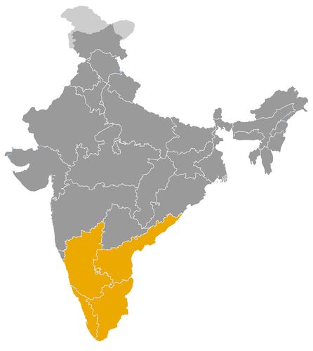
This map illustrates the maximum territory that the Chola Dynasty had reached at its height, covering the current regions of Karnataka, Kerala and Tamil Nadu in India. Its main purpose is to provide a visual aid to understand the geographical extent of this dynasty. However, it's important to note that the contemporary borders of these regions may not necessarily coincide with the historical territories.
The Chola Dynasty and Its Major Role in the History of India
A Tamil power that became an imperial force
The Chola dynasty occupies one of the most prominent places in the history of South India. Although the Cholas are mentioned in early Tamil literature, their best documented and most influential phase was the medieval imperial period, from the ninth to the thirteenth century. During this time, they transformed a regional Tamil kingdom into one of the most powerful states of medieval India.
Their political heartland lay in the fertile Kaveri valley, in present-day Tamil Nadu. This region provided the agricultural wealth, population base and administrative structure that allowed the dynasty to expand. Tanjavur became one of the major centres of Chola power, followed later by Gangaikonda Cholapuram, founded by Rajendra I to commemorate his northern campaign toward the Ganges.
The Cholas reached their greatest power under rulers such as Rajaraja I and Rajendra I. Their authority extended over much of South India, parts of Sri Lanka, and maritime zones linked to the Bay of Bengal. Their importance in Indian history lies not only in military conquest, but also in administration, temple construction, bronze sculpture, maritime trade and the formation of a powerful Tamil imperial culture.
A political system combining royal authority and local institutions
The Chola state was strongly royal, but it also depended on local institutions. The emperor was presented as a conqueror, protector of order and patron of religion. Royal inscriptions celebrated victories, donations, temple foundations and administrative decisions. Through these inscriptions, the dynasty projected an image of organised authority and sacred kingship.
The empire was divided into provinces, districts and smaller local units. Village assemblies and local councils played an important role, particularly in the fertile agricultural regions of Tamil Nadu. They managed land, taxation, irrigation, temple property and local obligations. This system did not mean that the monarchy was weak. Rather, Chola power worked through a combination of royal command and local cooperation.
The Cholas also developed a durable imperial ideology. Their kings adopted grand titles, marked their victories in inscriptions and used monumental architecture to make power visible. The temple, the palace and the inscription became instruments of rule. Political authority was therefore expressed not only through armies, but also through ritual, land grants and public memory.
Military expansion and control of South Indian politics
The Chola dynasty reshaped the political geography of South India. After Vijayalaya Chola captured Tanjavur in the ninth century, his successors expanded against the Pallavas in the north and the Pandyas in the south. By weakening these older powers, the Cholas became the dominant force in the Tamil region.
Their conflicts with the Western Chalukyas of the Deccan were among the major struggles of medieval South India. Control over frontier regions, especially in present-day Karnataka and Andhra Pradesh, was repeatedly contested. The Cholas also intervened in Vengi, where marriage alliances and dynastic links with the Eastern Chalukyas became politically important. The accession of Kulottunga I, who was connected to both the Chola and Eastern Chalukya lines, reflected this close relationship.
The Cholas were also notable for their maritime power. Under Rajaraja I and Rajendra I, they campaigned in Sri Lanka and projected naval force across the Bay of Bengal. Rajendra I’s expedition against Srivijaya in Southeast Asia showed that the Chola state could act beyond the Indian mainland. These campaigns were connected to trade, prestige and control of maritime routes.
Cultural influence through temples, inscriptions and bronze art
The cultural impact of the Cholas was exceptional. Their patronage transformed the sacred and artistic landscape of Tamil Nadu. The Brihadisvara Temple at Tanjavur, built under Rajaraja I, is one of the greatest monuments of medieval Indian architecture. Its scale, stone construction, inscriptions and ritual organisation reflect the strength of the Chola state.
Chola temples were not only religious monuments. They functioned as centres of worship, economic management, artistic production and local administration. They received land grants, employed priests, musicians, dancers, scribes and artisans, and recorded donations on their walls. In this way, temples became both sacred institutions and public archives of political society.
Chola bronze sculpture represents another major achievement. Images of Shiva Nataraja, Parvati, Vishnu, Krishna and other deities show a refined balance between theological symbolism, ritual function and artistic elegance. These bronzes were made for worship and procession, not simply for decoration. They remain among the most celebrated forms of Indian sacred art.
Economic strength based on agriculture and maritime trade
The economic foundations of Chola power lay in agriculture, especially in the Kaveri delta. Irrigation tanks, canals, embankments and river management supported intensive rice cultivation. Agricultural surplus made it possible to maintain temples, armies, officials and artisans.
The Cholas also benefited from long-distance trade. Ports on the Coromandel coast connected South India with Sri Lanka, the Maldives, Southeast Asia, China and the Islamic trading world. Textiles, spices, precious stones, metals, horses and luxury goods moved through these networks. Merchant guilds, coastal towns and temple institutions all participated in this economy.
This combination of agrarian wealth and maritime commerce gave the Cholas unusual strength. They were both a land empire and a sea-oriented power. Their political influence therefore extended beyond conquered territory into the commercial world of the Indian Ocean.
A lasting legacy in South Indian and Indian history
The Chola empire declined from the twelfth century onward, under pressure from the Pandyas, Hoysalas and other regional powers. By the thirteenth century, its imperial authority had largely disappeared. Yet its historical legacy remained profound.
The Cholas shaped the political, cultural and economic history of South India more deeply than most medieval dynasties. Their temples, inscriptions, bronzes, administrative practices and maritime connections left a durable mark on Tamil society and on the wider history of India. Their role was not limited to regional kingship. They created one of the most sophisticated imperial systems of medieval India and linked the Tamil country to the broader world of the Indian Ocean.
The Geographic Extent of the Chola Dynasty in India and the Indian Ocean
A Tamil heartland rooted in the Kaveri valley
The Chola dynasty developed its main power base in the Tamil region of South India, especially in the fertile Kaveri valley of present-day Tamil Nadu. This agricultural zone formed the political, economic and cultural heart of Chola authority. Its irrigated fields, dense village networks and temple-centred settlements provided the resources that allowed the dynasty to expand beyond its original core.
Although the Cholas are mentioned in early Tamil traditions, their most clearly documented territorial expansion belongs to the medieval period, beginning in the ninth century. Vijayalaya Chola captured Tanjavur and made it the foundation of renewed Chola power. From this base, his successors gradually extended their authority across the Tamil country. Tanjavur, and later Gangaikonda Cholapuram, became major centres of royal administration, ritual display and imperial ideology.
Control of the Tamil country and rivalry with the Pallavas and Pandyas
The first major phase of Chola expansion was directed toward the consolidation of the Tamil region. To the north, the Cholas advanced against the Pallavas, whose traditional centre was Kanchipuram. The weakening of Pallava authority allowed the Cholas to dominate northern Tamil areas and to inherit some of the political and cultural prestige associated with earlier South Indian kingship.
To the south, the Cholas confronted the Pandyas of Madurai. This rivalry remained one of the longest and most important conflicts in South Indian history. The Pandya country was strategically valuable because it controlled southern Tamil territories, religious centres and access to maritime routes near Sri Lanka. Chola control over Pandya lands was sometimes direct and sometimes unstable, but the repeated campaigns against Madurai show how essential the southern frontier was to imperial security.
By bringing much of the Tamil region under their authority, the Cholas created a territorial base stronger than that of many earlier regional powers. This base gave them access to agricultural surplus, temple wealth, manpower and coastal outlets.
Expansion toward Kerala, Karnataka and Andhra regions
Westward, the Cholas sought influence over the regions corresponding to present-day Kerala, then associated with the Chera or Perumal rulers. The Malabar coast was important because of its ports and its connections with the western Indian Ocean. Chola campaigns in this direction were part of a broader struggle for control over trade routes, coastal access and prestige among South Indian dynasties. Their authority in Kerala was not always permanent, but their interventions affected the balance between Tamil and western coastal powers.
To the northwest, the Cholas entered into prolonged conflict with the Western Chalukyas of the Deccan. This rivalry shaped much of the eleventh-century political geography of South India. The contested zones lay in present-day Karnataka and adjoining regions, where control shifted repeatedly between the two powers. These campaigns did not always produce stable annexation, but they prevented the Chalukyas from dominating the southern peninsula and allowed the Cholas to claim imperial status.
To the northeast, the Cholas intervened in Vengi, in present-day Andhra Pradesh. This region was ruled by the Eastern Chalukyas, who were linked to the Cholas through warfare, diplomacy and marriage alliances. Vengi became a crucial bridge between the Tamil country and the eastern Deccan. The accession of Kulottunga I, connected to both the Chola and Eastern Chalukya lineages, shows how territorial expansion and dynastic integration could reinforce each other.
Sri Lanka as a major field of conquest and resistance
One of the most important dimensions of Chola expansion was the conquest of Sri Lanka. Rajaraja I invaded the island and brought its northern regions under Chola control. Rajendra I extended the campaign further, and for a time much of Sri Lanka was administered as part of the Chola imperial sphere. Polonnaruwa became an important centre under Chola rule.
The occupation of Sri Lanka gave the Cholas access to strategic ports, agricultural resources and a central position in Indian Ocean traffic. It also enhanced their prestige as rulers capable of projecting power beyond the mainland. However, Chola domination of the island faced persistent local resistance. Sinhalese rulers and regional forces repeatedly sought to recover autonomy, making Sri Lanka both a prize of conquest and a costly frontier.
This expansion deeply influenced relations between the Cholas and the island’s rulers. It transformed Sri Lanka from a neighbouring kingdom into a contested imperial territory, while also linking the island more closely to South Indian political struggles.
Northern campaigns and symbolic reach to the Ganges
Under Rajendra I, Chola military ambition reached its most symbolic expression in the campaign toward the north. Chola forces claimed victories reaching the Ganges, and Rajendra founded Gangaikonda Cholapuram, meaning the city of the Chola who took the Ganges. This northern expedition did not create permanent Chola rule over North India, but it had great ideological importance.
The campaign allowed Rajendra to present himself as a universal conqueror whose authority extended beyond the southern peninsula. It also placed the Cholas in the symbolic geography of pan-Indian kingship. Their power remained rooted in the south, but their political imagination reached far beyond it.
Naval expeditions and influence across the Bay of Bengal
The Cholas were unusual among Indian dynasties for the scale of their naval operations. Their maritime power extended across the Bay of Bengal and into Southeast Asian waters. Rajendra I’s campaign against Srivijaya, whose centres controlled key routes around the Malay Peninsula and Sumatra, demonstrated the Chola ability to intervene in overseas trade networks.
These expeditions did not create a long-lasting overseas empire in the modern sense. They were more likely intended to secure commercial interests, display imperial authority and influence maritime routes. They nevertheless show that Chola geographic reach was not limited to land conquest. Their sphere of action included ports, sea lanes and trading communities across the eastern Indian Ocean.
A territorial system shaped by agriculture, temples and trade
The Chola empire combined a compact agrarian heartland with wider zones of conquest, influence and maritime projection. Its most stable territory remained the Kaveri valley and the Tamil country. Its contested regions included Pandya territory, Kerala, Karnataka, Vengi and Sri Lanka. Its symbolic and commercial reach extended toward the Ganges and Southeast Asia.
This geography shaped Chola relations with neighbouring dynasties. The Pallavas were absorbed as a declining northern Tamil power. The Pandyas remained enduring rivals in the south. The Chera or Perumal rulers contested western coastal influence. The Western Chalukyas challenged Chola expansion in the Deccan. The Eastern Chalukyas became both rivals and dynastic partners. Sri Lankan rulers resisted Chola occupation, while Southeast Asian powers encountered Chola naval force.
By the thirteenth century, Chola territory contracted under pressure from the Pandyas, Hoysalas and other regional powers. Yet the dynasty had already transformed the political map of South India. Its geographic expansion linked river valleys, temples, ports, islands and sea routes into one of the most dynamic imperial systems of medieval India.
This chronology presents the medieval and imperial Chola line from Vijayalaya to Rajendra III. The early Cholas mentioned in earlier Tamil literature are not included, because their succession and dates remain too uncertain for a continuous list of reigns.
- Vijayalaya Chola (c. 848–871) • Founder of medieval Chola power, he captured Tanjavur and established the territorial base of the imperial dynasty.
- Aditya I (c. 871–907) • He consolidated Chola expansion in the Tamil country and weakened Pallava authority.
- Parantaka I (907–955) • He expanded the kingdom southward and strengthened administration, but suffered setbacks against the Rashtrakutas.
- Gandaraditya (c. 955–957) • His reign was brief and appears to have been marked more by religious devotion than by military expansion.
- Arinjaya Chola (c. 956–957) • He ruled for a very short time during a phase of dynastic transition.
- Parantaka II Sundara Chola (c. 957–970) • He partly restored Chola power after the difficulties of the mid-tenth century.
- Uttama Chola (c. 970–985) • He ruled before the accession of Rajaraja I and maintained dynastic continuity.
- Rajaraja I (985–1014) • He transformed the kingdom into a maritime empire and built the great Brihadisvara Temple at Tanjavur.
- Rajendra I (1012–1044) • Associated with power before his father’s death, he led conquests to the Ganges and launched naval expeditions toward Southeast Asia.
- Rajadhiraja I (1018–1054) • Co-ruler and then emperor, he continued campaigns against the Western Chalukyas and died in battle.
- Rajendra II (1054–1063) • He succeeded Rajadhiraja I on the battlefield and maintained military pressure against the Chalukyas.
- Virarajendra Chola (1063–1070) • He stabilised the empire after several conflicts and intervened in Eastern Chalukya affairs.
- Athirajendra Chola (1070) • His very brief reign ended in a succession crisis.
- Kulottunga I (1070–1122) • Descended from both the Chola and Eastern Chalukya lines, he reorganised the empire and strengthened links with Vengi.
- Vikrama Chola (1118–1135) • Associated with power before his independent reign, he consolidated Chola authority in southern India.
- Kulottunga II (1133–1150) • His reign was marked by administrative continuity and religious patronage.
- Rajaraja II (1146–1173) • He ruled an empire that remained prestigious but faced growing regional pressures.
- Rajadhiraja II (1166–1178) • He ruled during a period of rivalry with the Pandyas, Hoysalas and other southern powers.
- Kulottunga III (1178–1218) • The last major Chola ruler, he campaigned against the Pandyas and supported major religious projects.
- Rajaraja III (1216–1256) • His reign was marked by political decline, Hoysala interventions and the rise of Pandya power.
- Rajendra III (1246–1279) • The last effective Chola emperor, he tried to preserve dynastic autonomy against Pandya hegemony.