

 Français (France)
  Nederlands (nl-NL)
 Of Hindu tradition, (with additional Buddhist, Jain and Christian influence), the Chera dynasty ruled for approximately 600 years, ± between -300 and 300 over all or part of South India, during the Ancient Period.
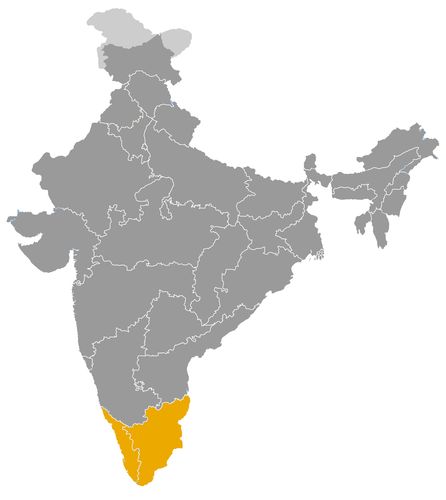
This map illustrates the maximum territory that the Chera Dynasty had reached at its height, covering the current regions of Kerala and Tamil Nadu in India. Its main purpose is to provide a visual aid to understand the geographical extent of this dynasty. However, it's important to note that the contemporary borders of these regions may not necessarily coincide with the historical territories.
The Chera Dynasty and the Historical Role of Kerala in South India
An ancient dynasty linked to the Malabar Coast
The Chera dynasty occupies an important place in the history of South India, especially in relation to Kerala and the Malabar Coast. The name Chera refers to more than one historical phase. The early Cheras are mainly known through Sangam Tamil literature, while the later Chera Perumals of Mahodayapuram belong to a medieval period that is better documented through inscriptions and regional traditions. These two phases are connected by dynastic memory, geography and cultural identity, but they should not always be treated as one continuous political line.
The early Cheras formed one of the three major powers of the classical Tamil world, alongside the Cholas and the Pandyas. Their territories were associated with the western side of the peninsula, where the Western Ghats meet the Arabian Sea. This location gave them a distinctive role in South Indian history: they were both a Tamil political power and a coastal kingdom deeply connected with maritime exchange.
A political bridge between Kerala and the Tamil world
The Cheras were positioned between two important zones: the Tamil-speaking plains to the east and the Malabar Coast to the west. This geography shaped their political role. Unlike the Cholas, whose power was strongly linked to the Kaveri basin, or the Pandyas, who were centred farther south, the Cheras controlled routes between the mountains, the spice-producing hinterland and the western ports.
In the Sangam period, Chera rulers appear as kings involved in warfare, gift-giving, diplomacy and rivalry with the Cholas and Pandyas. These accounts combine poetic convention with historical memory, but they show that the Cheras were recognized as one of the principal royal houses of the Tamil region.
In the medieval period, the Chera Perumals of Mahodayapuram helped shape the political formation of Kerala. Their centre, usually associated with the Kodungallur region, was well placed near riverine routes and maritime trade. Their kingdom was not a centralized state in the modern sense. It relied on a network of local chiefs, Brahmanical institutions, temples, merchant groups and regional authorities.
Maritime trade as a foundation of Chera power
One of the most distinctive features of Chera history was its connection with Indian Ocean trade. The Malabar Coast was famous from antiquity for pepper, spices, timber, ivory and other valuable products. These goods attracted merchants from the Mediterranean world, Arabia, Persia and later wider Asian trading networks.
Ports associated with the Chera region, especially ancient Muziris and later coastal centres such as Kodungallur, played a major role in this commercial system. Maritime trade gave the Chera territories an economic importance that exceeded their geographic size. The flow of goods, merchants and foreign contacts shaped local society and linked Kerala to wider commercial worlds.
This economic position also influenced politics. Control over ports, routes through the Western Ghats and access to spice-producing regions strengthened royal authority. It also made the Chera country attractive to rival powers, especially when the Cholas later sought greater influence over the western coast.
Religious diversity and temple-centred authority
The Chera realm was marked by religious diversity. Hindu temples became central institutions, especially during the Chera Perumal period. They were not only places of worship but also economic and social centres. Temples received land, organized ritual life, employed specialists and connected royal authority with local elites.
Brahmanical settlements and temple networks played an important role in the organization of medieval Kerala. Royal legitimacy was expressed through donations, patronage and association with sacred sites. This form of authority differed from a purely military model of kingship. It depended on ritual prestige, regional alliances and the management of land and resources.
The Malabar Coast was also home to old Jewish, Christian and Muslim communities, many of them linked to maritime trade. Their presence reflects the openness of the region to long-distance contacts. While these communities were not created by the Chera state alone, they formed part of the social and economic environment in which Chera power operated.
Cultural influence through literature and regional identity
The early Cheras occupy a significant place in Sangam literature. Poems refer to their rulers, battles, generosity, ports, landscapes and interactions with other Tamil powers. These texts are not straightforward political chronicles, but they preserve a valuable memory of royal culture, warrior ideals and the economic life of ancient South India.
The Chera name also contributed to the later regional identity of Kerala. The transition from the older Tamil cultural world to the more distinct historical formation of Kerala was gradual. The Chera Perumals played an important part in that process by linking political authority, temple institutions, landholding structures and maritime exchange within a specifically western coastal setting.
The cultural importance of the Cheras therefore lies not only in literature, but also in the formation of a regional historical consciousness. They helped connect ancient Tamil traditions with the medieval society of Kerala.
Architecture adapted to the environment of Kerala
The architectural legacy associated with the Chera world must be understood in relation to Kerala’s climate and materials. Unlike the stone temple complexes of Tamil Nadu or Karnataka, Kerala architecture often used wood, laterite, sloping roofs and forms adapted to heavy monsoon rainfall. This produced a distinctive architectural tradition shaped by environment, ritual requirements and local craftsmanship.
During the Chera Perumal period, temples became important centres of social and economic organization. Their architecture and institutional role helped define the sacred landscape of Kerala. These structures were part of a wider system in which religion, land, water, trade and political authority were closely connected.
A lasting dynasty in the history of South India
The Chera dynasty did not create a permanently centralized empire comparable to some later South Indian states. Its importance lies instead in its long regional influence, its maritime orientation and its role in shaping Kerala’s historical identity. The Cheras connected the Tamil world with the Malabar Coast, the Western Ghats with the Arabian Sea, and local political authority with Indian Ocean trade.
Their legacy remained visible after the decline of the Chera Perumals, when Kerala fragmented into regional powers such as Venad, Kolathunad and other local polities. The Chera tradition nevertheless continued to provide a historical framework for understanding Kerala as a coastal, commercial and culturally distinctive region within the broader history of India.
The Geographic Expansion of the Chera Dynasty between Kerala, the Tamil World and the Malabar Coast
A western South Indian power facing the Arabian Sea
The Chera dynasty is mainly associated with the western side of South India, especially Kerala and the Malabar Coast. Its geographic history must be approached with caution, because the name Chera refers to more than one historical phase. The early Cheras of the Sangam age are known largely through Tamil literary traditions, while the later Chera Perumals of Mahodayapuram belong to a medieval period more securely connected with inscriptions and regional institutions.
The Chera realm was therefore not a single uninterrupted state with fixed borders. It was a long-lasting political tradition rooted in the western coastal zone, between the Western Ghats and the Arabian Sea. This location gave the Cheras a distinct position compared with the Cholas and Pandyas, whose main bases lay farther east and south in the Tamil plains.
The Malabar Coast as the core of Chera power
The principal territorial base of the Cheras lay along the Malabar Coast. This region included narrow coastal plains, river valleys, forested hills and access routes through the Western Ghats. Its geography was very different from the broad agrarian basins of the eastern coast. The Chera country was shaped by mountains, monsoon rivers, ports and products from the hinterland.
In antiquity, the Chera sphere was linked with ports such as Muziris and with inland regions producing pepper, spices, timber, ivory and other valuable goods. The control of routes between the Ghats and the coast gave the Cheras access to commercial wealth. Their authority was therefore connected not only with land, but also with the movement of goods from upland zones to maritime outlets.
This coastal orientation made the Chera territory economically important within the wider Indian Ocean world. Even when their political territory was not vast, their access to trade gave them influence beyond the limits of their land power.
Connections across the Western Ghats toward the Tamil region
The early Cheras were part of the classical Tamil political world. Their western base did not isolate them from the Cholas and Pandyas. Routes across the Western Ghats linked the Malabar Coast with the Tamil plains, especially through regions such as Kongu and other inland corridors.
These connections shaped Chera expansion and diplomacy. The Cheras competed with the Cholas and Pandyas for prestige, tribute, routes and alliances. Literary traditions describe warfare, gift exchange and rivalry among the three crowned Tamil dynasties. Although the exact territorial borders of the early Chera kingdom remain uncertain, its influence clearly extended across zones connecting the western coast with the Tamil interior.
This geography gave the Cheras a dual identity. They were western coastal rulers, but they also belonged to the broader Tamil political and cultural sphere. Their relations with neighbouring dynasties were therefore shaped by both coastal trade and inland rivalry.
Mahodayapuram and the medieval formation of Kerala
In the medieval period, the Chera Perumals ruled from Mahodayapuram, generally associated with the Kodungallur region in central Kerala. This location was strategically important because it lay near river systems, fertile coastal zones and maritime routes. From this centre, the Chera Perumals exercised authority over much of Kerala, though not through a strongly centralized system.
Their realm consisted of a royal centre, temple networks, Brahmanical settlements, local chiefs, merchant groups and regional powers. Authority was layered and negotiated. Some areas may have recognized the king’s ritual or political superiority while retaining strong local autonomy. This pattern was typical of medieval Kerala, where temples, landholding groups and local authorities played a major role in territorial organization.
The geography of the Chera Perumal realm was therefore not merely military. It was institutional, religious and commercial. Temples and ports were as important as forts or royal centres in structuring the kingdom.
Relations with the Cholas and Pandyas along contested frontiers
The territorial position of the Cheras strongly influenced their relations with neighbouring dynasties. To the east, the Cholas controlled the Kaveri basin and later developed into an expansive imperial power. To the south-east, the Pandyas held territories connected with the southern Tamil region. Both dynasties had reasons to seek access to the western coast.
From the tenth and eleventh centuries, Chola pressure became especially important. Chola rulers aimed to influence or control routes leading to the Malabar Coast, partly because of the commercial value of western ports and spice-producing regions. This brought the Chera Perumals into direct contact and conflict with Chola ambitions.
The Pandyas also interacted with the Chera sphere, especially in southern Kerala and the adjoining Tamil zones. Borders in these regions were not fixed lines, but shifting zones of military pressure, alliances and local autonomy. The geography of mountains and passes made frontier control both difficult and strategically valuable.
Ports, trade and the wider Indian Ocean setting
The maritime dimension of Chera territory was one of its defining features. The Malabar Coast connected South India with the Arabian Sea, the Persian Gulf, the Red Sea and other parts of the Indian Ocean. Merchants from western Asia, the Mediterranean world and later Islamic trading networks were drawn to the region’s pepper and other products.
This trade shaped the political geography of the Cheras. Control over ports and access routes gave local rulers economic resources and diplomatic importance. It also encouraged the settlement or presence of diverse religious communities, including Jewish, Christian and Muslim groups in the Malabar region.
The Cholas’ later interest in the western coast can be understood partly through this commercial geography. The Chera realm was valuable because it controlled a coastal interface between South India and long-distance maritime exchange.
Fragmentation after the decline of Chera Perumal authority
The decline of the Chera Perumals led to the fragmentation of Kerala into several regional powers, including Venad, Kolathunad, Kochi and other local polities. This transition suggests that Chera authority had rested on a network of regional relationships rather than on a permanently centralized state.
The geographic legacy of the Cheras remained significant. They helped define Kerala as a region shaped by the sea, the Western Ghats, temple institutions, port towns and trade networks. Their territory linked the Tamil world with the Malabar Coast and connected South India with the Indian Ocean. The Chera dynasty therefore stands as a western, maritime and regional power whose geography deeply influenced its political role in the history of India.
This chronology brings together two groups often associated with the Chera name: the early Cheras of the Sangam age, known mainly through Tamil literature and genealogical traditions, and the later Chera Perumals of Mahodayapuram, better attested in medieval Kerala. The early reigns are highly approximate and should not be understood as a perfectly established continuous succession. The rulers are generally described as kings, although exact titles vary according to sources, languages and inscriptions.
- Uthiyan Cheralathan (c. 1st century CE) • He is presented in Sangam tradition as one of the earliest great Chera kings of ancient Kerala.
- Nedum Cheralathan (c. 1st–2nd century CE) • He is described as a prestigious ruler associated with the expansion of Chera power and maritime trade.
- Palyani Sel Kelu Kuttuvan (c. 2nd century CE) • He belongs to the early phase of the dynasty and is mainly known through Tamil poetic traditions.
- Kalankai Kanni Narmudi Cheral (c. 2nd century CE) • He is mentioned as a Chera king in literary sources, with uncertain chronology.
- Senguttuvan Chera (c. 2nd century CE) • Also called the Red Chera or Kadal Pirakottiya Senguttuvan, he is one of the most famous rulers of Chera tradition.
- Adu Kottu Pattu Cheral Athan (c. 2nd century CE) • His reign belongs to the Sangam period, whose dating remains debated.
- Selva Kadumko Vali Athan (c. 2nd century CE) • He is associated with the Irumporai line and the assertion of Chera power in the western Tamil region.
- Perum Cheral Irumporai (c. 2nd–3rd century CE) • He is traditionally linked to conflicts with other Tamil powers, especially around Tagadur.
- Yanaikkat-sei Mantaran Cheral Irumporai (c. 3rd century CE) • He appears among the later ancient rulers mentioned in Sangam tradition.
- Kanaikkal Irumporai (c. 3rd century CE) • He is often placed in the late phase of the early Cheras, before a long and less documented transition.
- Kulashekhara Varman (c. 800–820 CE) • He is usually placed at the beginning of the Chera Perumal line of Mahodayapuram.
- Rajasekhara Varman (c. 820–844 CE) • He consolidated medieval Chera power in Kerala and is associated with the religious environment of his period.
- Sthanu Ravi Varman (c. 844–885 CE) • His reign is better attested by inscriptions and corresponds to an important phase of the medieval Chera kingdom.
- Rama Varma Kulashekhara (c. 885–917 CE) • He maintained Chera Perumal authority in a context of relations with neighbouring South Indian kingdoms.
- Goda Ravi Varman (c. 917–944 CE) • He belonged to the dynastic continuity of Mahodayapuram and ruled a kingdom linked to Kerala’s religious and commercial networks.
- Indu Kotha Varman (c. 944–962 CE) • His reign is poorly detailed, but it belongs to the stable phase of the Chera Perumals.
- Bhaskara Ravi Varman I (c. 962–1019 CE) • He ruled for a long period associated with important commercial and religious contacts on the Malabar coast.
- Bhaskara Ravi Varman II (c. 1019–1021 CE) • His brief reign followed the long rule of Bhaskara Ravi Varman I.
- Vira Kerala (c. 1021–1028 CE) • He ruled during a period marked by growing Chola pressure on Kerala.
- Rajasimha (c. 1028–1043 CE) • He maintained Chera power while the regional balance was altered by Chola ambitions.
- Bhaskara Ravi Varman III (c. 1043–1082 CE) • His reign belongs to the late phase of the Chera Perumals, in a more fragmented political context.
- Ravi Rama Varman (c. 1082–1090 CE) • He is generally placed among the last rulers of Mahodayapuram.
- Rama Varma Kulashekhara (c. 1090–1102 CE) • He is often regarded as the last major Chera Perumal before the political fragmentation of medieval Kerala.
 Links to the main sections of the site