

 Français (France)
  Nederlands (nl-NL)
 Of Sikh tradition, (with additional Hindu influence), the Phulkian of Patiala dynasty ruled for approximately 348 years, ± between 1600 and 1948 over all or part of North India, during the Medieval Period, the Colonial Period and the Modern Period.
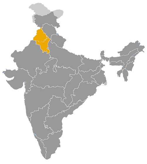
This map illustrates the maximum territory that the Phulkian of Patiala Dynasty had reached at its height, covering the current regions of Haryana and Punjab in India. Its main purpose is to provide a visual aid to understand the geographical extent of this dynasty. However, it's important to note that the contemporary borders of these regions may not necessarily coincide with the historical territories.
The Phulkian Dynasty of Patiala and Its Role in the History of Princely Punjab
The leading branch of the Phulkian house
The Phulkian dynasty of Patiala was one of the most important Sikh ruling houses in north-western India. It belonged to the wider Phulkian family, traditionally descended from Chaudhary Phul, and was closely related to the ruling branches of Nabha and Jind. Among these related dynasties, Patiala became the most powerful, the most territorially extensive and the most politically visible. Its history illustrates the transformation of a regional Sikh lineage into a recognised princely state under British paramountcy and, later, into part of independent India.
The role of Patiala in Indian history was mainly regional, but it was not marginal. The dynasty occupied a central position in the Malwa region of Punjab, in the politics of the Cis-Sutlej Sikh states and in the broader system of princely India. Through territorial control, administrative consolidation, dynastic prestige and cultural patronage, Patiala became one of the principal powers of princely Punjab.
The formation of a Sikh princely power in Malwa
The rise of Patiala took place in the eighteenth century, during a period of political fragmentation in north-western India. Mughal authority was weakening, Afghan incursions repeatedly affected Punjab, and Sikh chiefs and misls were expanding their influence. In this context, Ala Singh is generally regarded as the effective founder of Patiala’s power. From his time onward, the Phulkian branch of Patiala gradually consolidated a territorial base in the Malwa region.
This development was not merely a military process. The dynasty converted lineage authority, armed leadership and control over local communities into a more stable princely structure. Villages, agricultural lands, market centres and revenue rights became the foundation of state power. By building institutions of rule around these resources, Patiala became more than a chiefship and emerged as a durable regional state.
Political leadership among the Cis-Sutlej Sikh states
Patiala occupied a dominant position among the Cis-Sutlej Sikh states. These states lay on the side of the Sutlej River that came increasingly under British protection in the early nineteenth century. Patiala’s relations with Nabha and Jind were shaped by shared Phulkian descent, but also by differences in size, wealth, rank and political ambition.
The three Phulkian branches were linked by kinship, yet they remained separate states. Patiala’s greater territorial strength gave it a superior position, but did not eliminate rivalry. Questions of precedence, boundaries, recognition and influence continued to matter. In this political environment, Patiala acted as the leading Phulkian state, while Nabha and Jind preserved their own identities and interests.
British protection changed the political geography of the region. Patiala retained internal autonomy, but its external diplomacy and military independence were restricted. This arrangement limited expansionist possibilities, while also protecting the dynasty from absorption by stronger powers. As a result, Patiala became a stable princely state within the colonial order.
A major princely state under British paramountcy
Under British paramountcy, Patiala became one of the most prominent princely states in northern India. Its rulers held a high rank in the princely hierarchy and participated in the political culture of the Raj. Their status reflected the state’s size, resources, strategic location and loyalty within the imperial system.
The dynasty’s role was to govern internally while operating within the limits imposed by British authority. Patiala administered its territory, collected revenue, maintained local order, supported public institutions and represented princely continuity in Punjab. At the same time, major questions of defence, foreign relations and regional security were controlled by the British.
This dual position was typical of princely India. Patiala was neither fully sovereign in the modern sense nor simply a British district. It was a protected princely state with internal authority, dynastic legitimacy and a recognised place in the imperial political structure.
Agrarian resources and administrative development
The economic base of Patiala rested mainly on agriculture and land revenue. The Malwa region provided villages, cultivated fields, rural markets and local networks that sustained the state. Revenue from land supported the court, administrative offices, local forces, public works and the cultural activities associated with princely authority.
Compared with Nabha and Jind, Patiala possessed greater resources and a broader territorial base. This allowed the state to maintain more visible institutions and a more elaborate court. Under colonial influence, fiscal administration, legal structures, public works and urban services became increasingly formalised. The rulers’ economic role was therefore closely tied to territorial management and administrative modernisation.
Patiala was not a maritime trading power or a large industrial centre. Its economic significance lay in the organisation of agrarian production, revenue collection and regional governance. This made the dynasty an important actor in the economic history of princely Punjab.
Cultural patronage and Sikh princely identity
The Phulkian dynasty of Patiala was a Sikh ruling house, and its legitimacy was linked to Sikh lineage traditions, the memory of eighteenth-century Sikh power and the political culture of the Malwa region. However, the state governed a religiously diverse population, including Sikhs, Hindus and Muslims. Its cultural role therefore combined Sikh identity with the broader responsibilities of a multi-community princely state.
The rulers of Patiala supported religious institutions, ceremonies, education, public buildings and courtly culture. Palaces, forts, residences and ceremonial spaces expressed princely authority and helped shape the architectural identity of Patiala. Cultural patronage reinforced the dynasty’s prestige and gave visible form to its political status.
This cultural role was not separate from politics. Patronage helped connect the ruling house with local elites, religious communities and administrative institutions. It allowed the dynasty to present itself as both a Sikh house and a legitimate regional authority.
Integration into independent India
The effective sovereignty of Patiala ended after Indian independence, when the state was integrated into the Patiala and East Punjab States Union in 1948. Yadavindra Singh, the last effective ruler, participated in this transition from princely sovereignty to integration within the Indian Union.
The Phulkian dynasty of Patiala occupies a major place in the history of north-western India. It links the rise of Sikh regional power, the politics of the Cis-Sutlej states, the British princely system, agrarian administration and the reorganisation of Punjab after independence. As the leading branch of the Phulkian house, Patiala had a stronger political, economic and cultural impact than Nabha or Jind, and remains central to understanding the history of princely Punjab.
The Geographical Extension of the Phulkian Dynasty of Patiala in Princely Punjab
A Phulkian state centred on the Malwa region of Punjab
The Phulkian dynasty of Patiala ruled one of the most important Sikh princely states in north-western India. Its territorial base lay mainly in the Malwa region of historical Punjab, a broad area south of the Sutlej River that became central to the rise of several Sikh ruling houses in the eighteenth century. Like Nabha and Jind, Patiala belonged to the wider Phulkian house, traditionally descended from Chaudhary Phul. Unlike the other branches, however, Patiala developed into the largest and most influential Phulkian state.
The geographical extension of Patiala explains much of its political importance. The state was not an empire comparable to the great imperial powers of Indian history, but within the context of princely Punjab it controlled a substantial and coherent territory. Its lands included the capital of Patiala, secondary towns, agricultural villages, revenue districts, local markets and communication routes. This territorial base gave the dynasty the resources needed to maintain a court, administer its population and assert its rank among neighbouring states.
Patiala as the dynastic and administrative capital
The city of Patiala formed the political, administrative and symbolic centre of the dynasty. It gave the state its name and became the visible expression of Phulkian power. The royal court, princely residences, administrative institutions, ceremonial spaces and urban markets were concentrated there. As the state expanded and consolidated, Patiala became more than a local stronghold. It became the capital of a recognised princely state.
The importance of the city also lay in its ability to represent dynastic identity. Palaces, forts and public buildings helped distinguish Patiala from the related states of Nabha and Jind. In a region where several ruling houses shared a common Phulkian ancestry, the possession of a strong capital reinforced the separate status of the Patiala branch and supported its claim to precedence within the family network.
Agricultural territory and the economic basis of power
The territorial strength of Patiala rested largely on agricultural land. The Malwa region was characterised by villages, cultivated fields, rural markets and revenue networks. Control over these resources allowed the dynasty to finance its administration, local forces, courtly life and public works. The state’s geography was therefore closely linked to its economic power.
Patiala’s agrarian base was larger and more productive than that of Nabha and Jind. This gave the dynasty greater capacity to sustain political authority and cultural patronage. Revenue from land made it possible to support religious institutions, maintain roads and administrative centres, and fund the visible symbols of princely power. The extension of the state was thus not only a matter of territorial size, but also of the ability to organise land, labour, taxation and local authority.
Rajpura and the strategic value of regional routes
Rajpura was one of the important localities associated with the Patiala state. Its position in present-day Punjab illustrates the importance of communication routes within the territory. Patiala’s lands were connected to roads linking the Malwa region with other parts of Punjab, the areas toward present-day Haryana and the approaches to Delhi. These routes gave the state strategic and economic value.
Control over such localities strengthened Patiala’s ability to manage trade, movement, taxation and administrative communication. The dynasty’s influence did not depend only on the capital city, but also on a network of towns and rural centres that tied the state together. This network helped Patiala operate as a regional power within princely Punjab rather than as a small isolated court.
Relations with Nabha and Jind in the Phulkian sphere
Patiala’s geographical extension strongly influenced its relations with Nabha and Jind. The three states shared a common Phulkian origin, but each controlled its own territory and defended its own political interests. Patiala’s larger size and stronger resource base gave it a leading position within this group.
This dominance did not remove rivalry. Kinship created a framework of shared legitimacy, but proximity created competition over rank, influence, boundaries and recognition. Nabha had to preserve its autonomy in the shadow of Patiala, while Jind maintained a separate territorial identity linking parts of present-day Haryana and Punjab. Patiala’s greater territorial weight made it the principal Phulkian power, but also required careful management of relations with its related neighbours.
Patiala among the Cis-Sutlej Sikh states
Patiala belonged to the group of Cis-Sutlej Sikh states, situated on the side of the Sutlej River that came under British protection in the early nineteenth century. This geographical position was historically significant. The region lay between the Sikh kingdom of Lahore to the north-west, the British sphere of influence to the south-east, and a group of Sikh principalities in the Malwa area.
The location of Patiala made it important in the British effort to stabilise the Cis-Sutlej zone and limit the expansion of Maharaja Ranjit Singh across the Sutlej. British protection changed the political meaning of Patiala’s territory. It preserved the state from absorption by stronger neighbours, but also restricted its freedom in foreign and military affairs. The dynasty retained internal authority while becoming part of the wider colonial princely order.
Territorial stability under British paramountcy
Under British paramountcy, Patiala’s territory became more clearly stabilised as a princely state. The rulers continued to administer their lands, collect revenue and manage internal affairs, but the state’s external relations were controlled by the British. This arrangement reduced the likelihood of major territorial expansion, while protecting the dynasty’s recognised status.
Territorial stability allowed Patiala to strengthen its administration and develop its capital. The state’s geography became less a field for conquest and more a framework for governance. Roads, revenue systems, local institutions and public buildings became central to the expression of power. Patiala’s rulers derived authority from the management of a recognised domain rather than from continuous military growth.
A regional territory with lasting political significance
The Phulkian dynasty of Patiala controlled a substantial princely territory centred on Patiala and connected to localities such as Rajpura. Its lands lay mainly in the Malwa region of Punjab, but its political influence extended across the wider Cis-Sutlej zone. This geography shaped its relations with Nabha, Jind, other Sikh states, the British authorities and the Sikh kingdom of Lahore.
Patiala’s territorial base made it the leading branch of the Phulkian house. Its size, agricultural resources, strategic routes and recognised princely status gave it a stronger role than its related neighbours. Its integration into the Patiala and East Punjab States Union in 1948 ended its effective sovereignty, but the geographical legacy of the state remained important in the political reorganisation of Punjab after Indian independence.
The chronology distinguishes the cultural origin of the Phulkian house, traditionally linked to Chaudhary Phul in the seventeenth century, from the effective sovereignty of the Patiala branch, established in the eighteenth century. The earliest figures belong to the dynastic and lineage trunk; the rulers of Patiala later bore the titles of raja, Raja-i-Rajgan and then maharaja, in forms recognised or confirmed in the Afghan and later British context.
Common dynastic origin of the Phulkian house, c. 1600–1761
- Chaudhary Phul (first half of the seventeenth century, traditional lineage chief) • The eponymous ancestor of the Phulkian house, he is associated with the common origin of the Patiala, Nabha and Jind branches.
- Rama Singh (second half of the seventeenth century, genealogical tradition) • A descendant of Phul, he belongs to the lineage transmission before the formation of Patiala State.
- Baba Ala Singh (c. 1714–1761, territorial chief before recognised sovereignty) • A Phulkian chief in the Malwa region of Punjab, he gradually built the power that became Patiala State.
Rulers of Patiala, 1761–1948
- Ala Singh (1761–1765) • Effective founder of Patiala State, he asserted Phulkian authority in Malwa and obtained political recognition from Ahmad Shah Durrani.
- Amar Singh (1765–1781) • Raja of Patiala, he enlarged the state and received the title Raja-i-Rajgan.
- Sahib Singh (1781–1813) • Raja-i-Rajgan of Patiala, he ruled during a period of regional pressure and closer relations with British power.
- Karam Singh (1813–1845) • The first Patiala ruler commonly recognised as maharaja, he ruled under British protection after the arrangements concerning the Cis-Sutlej states.
- Narinder Singh (1845–1862) • Maharaja of Patiala, he supported the British during the conflicts of the mid-nineteenth century and consolidated the state’s princely status.
- Mahendra Singh (1862–1876) • Maharaja of Patiala, he first ruled under supervised administration because of his minority.
- Rajinder Singh (1876–1900) • Maharaja of Patiala, he was associated with the modernisation of the state and strong princely visibility in British India.
- Bhupinder Singh (1900–1938) • An influential maharaja, he gave Patiala an important political, diplomatic and sporting role in princely India.
- Yadavindra Singh (1938–1948, effective ruler) • The last ruling maharaja of Patiala, he acceded to the Indian Union and later became rajpramukh of the Patiala and East Punjab States Union.
 Links to the main sections of the site