

 Français (France)
 Nederlands (nl-NL)
Of Hindu tradition, (with additional Islamic, Jain and Christian influence), the Bhonsle of Kolhapur dynasty ruled for approximately 239 years, ± between 1710 and 1949 over all or part of South India and West India, during the Colonial Period and the Modern Period.
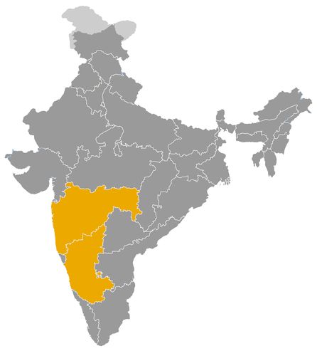
This map illustrates the maximum territory that the Bhonsle of Kolhapur Dynasty had reached at its height, covering the current regions of Karnataka and Maharashtra in India. Its main purpose is to provide a visual aid to understand the geographical extent of this dynasty. However, it's important to note that the contemporary borders of these regions may not necessarily coincide with the historical territories.
The Bhonsle Dynasty of Kolhapur: Maratha Kingship, Social Reform and Regional Development
A Royal Branch Emerging from Shivaji’s Succession
The Bhonsle dynasty of Kolhapur was a major branch of the Maratha royal house associated with Shivaji. Its history as a separate ruling power began around 1710 and ended when Kolhapur State merged with Bombay on 1 March 1949. Based in southern Maharashtra, with additional possessions in present day Karnataka, it maintained a distinct political identity through Maratha expansion, British supremacy and the transition to Indian independence.
The branch emerged from the succession dispute between Shahu, Shivaji’s grandson, and Tarabai, the widow of Rajaram. Following Shahu’s release from Mughal captivity in 1707, Tarabai defended the claims of her son Shivaji II. Their struggle produced rival royal centres at Satara and Kolhapur. In 1714, a palace coup displaced Tarabai and her son in favour of Sambhaji II, another son of Rajaram.
Kolhapur within the Maratha Political Order
The Treaty of Warna in 1731 stabilized the division between the two royal branches. Kolhapur retained its monarchy and territorial possessions, while Shahu maintained precedence within the wider Maratha order. This arrangement reflected a political structure containing several competing centres rather than a uniformly administered empire.
Kolhapur’s rulers bore the title chhatrapati, asserting continuity with Shivaji’s kingship. Their practical authority nevertheless depended on relationships with landed families, military commanders and subordinate estate holders.
Relations with the peshwas and neighbouring chiefs involved recurrent disputes over territory, revenue and communications. Despite Pune’s emergence as the principal centre of Maratha government, Kolhapur preserved its separate existence. Its survival demonstrates the resilience of regional royal institutions within the expanding Maratha political system.
British Paramountcy and Administrative Intervention
Kolhapur’s relations with the British developed through maritime disputes and regional competition. Successive agreements during the early nineteenth century restricted its external independence. The state retained a hereditary monarchy and internal administration under British paramountcy.
Royal minorities, court rivalries and administrative difficulties created opportunities for British intervention. Officials influenced ministerial appointments and the organization of government. In 1844, resistance by hereditary fortress garrisons revealed tensions surrounding administrative reform and the erosion of established privileges.
Kolhapur consequently illustrates the characteristic position of an Indian princely state under colonial rule. Its dynasty remained a significant source of local authority, but its political freedom operated within limits enforced by the British government.
Agriculture, Commerce and Economic Modernization
Agriculture supplied the principal foundation of Kolhapur’s economy. Land revenue supported the administration, while markets connected the plateau with the western coastal region. Grain, cotton, tobacco and sugar products contributed to regional exchange.
Economic development became a prominent concern under Shahu, whose personal administration lasted from 1894 to 1922, following his accession as a minor in 1884. His government encouraged irrigation, communications and industrial activity. The initiation of the Radhanagari dam project expressed an ambition to improve water availability and agricultural productivity.
Support for textile production and commercial enterprise also broadened the economic base. These policies did not remove rural inequalities, but they strengthened the role of the princely administration in infrastructure and development.
Shahu and the Expansion of Social Opportunity
Kolhapur’s importance in Indian history rests particularly on the reforms of Shahu, widely remembered as Rajarshi Shahu. His government sought to widen access to education and public employment among communities disadvantaged by prevailing social hierarchies.
In 1902, he reserved half of state service vacancies for groups then classified as backward. This measure became an important early precedent for policies of representation and reservation in India.
Shahu supported schools, community boarding institutions and compulsory primary education. He also challenged practices associated with untouchability and caste exclusion. His encouragement of Bhimrao Ramji Ambedkar and movements representing oppressed communities gave Kolhapur an influence extending beyond its territorial boundaries.
Religious Patronage and Cultural Institutions
The dynasty maintained a Hindu royal identity while supporting Muslim, Jain and Christian institutions, particularly through educational patronage. This approach allowed different communities to participate in the state’s institutional development.
The court also encouraged music, theatre, wrestling and other artistic traditions. Such patronage helped establish Kolhapur’s cultural reputation and contributed to the environment in which it became an important centre of Marathi cinema during the twentieth century.
Following Indian independence in 1947, the state moved towards political integration. Its merger with Bombay in 1949 ended the dynasty’s territorial government. The Bhonsles’ lasting significance lies in the combination of Maratha royal continuity, regional economic initiatives and social reforms that helped shape modern Maharashtra.
The Bhonsle Dynasty of Kolhapur: Territorial Development and Relations with Neighbouring Powers
A Kingdom between the Deccan Plateau and the Western Coast
The Bhonsle dynasty of Kolhapur governed territories situated principally in southern Maharashtra, with additional possessions in northern Karnataka. Established as a separate ruling branch around 1710, it maintained a distinct state until its merger with Bombay on 1 March 1949.
Its territory combined agricultural plains, river valleys, mountain fortresses and routes through the Western Ghats. This varied geography supported exchanges between the Deccan plateau and the Konkan coast. It also complicated government, since mountainous districts and detached possessions required arrangements with local commanders and hereditary estate holders.
Kolhapur’s historical territory should therefore be distinguished from the modern district bearing its name. Its boundaries changed, and its authority included both directly administered districts and subordinate estates.
The Maratha Succession and the Formation of Boundaries
The kingdom emerged from the succession struggle following Shahu’s release from Mughal captivity in 1707. As Shivaji’s grandson, Shahu claimed the Maratha throne. Tarabai, the widow of Rajaram, defended the rights of her son Shivaji II.
Their rivalry divided commanders and regional interests. Shahu established his authority at Satara, while Tarabai maintained a political and military base around Panhala and Kolhapur. In 1714, a palace coup replaced Shivaji II with Sambhaji II, another son of Rajaram.
The Treaty of Warna in 1731 stabilized the division between the two royal branches. The Warna River became an important geographical reference in their territorial settlement. Kolhapur consequently retained a separate domain, distinct from Satara and from territories subsequently acquired by other Maratha houses.
The Territorial Heartland around Kolhapur and Panhala
The kingdom’s core lay around Kolhapur, also known as Karvir, in the Panchganga basin. Cultivated lands supplied essential revenues, while routes linking the plateau with mountain passes increased the region’s strategic importance.
Panhala was a major military position. Its fortress overlooked important communications and provided a defensible royal base during the early history of the branch. Kolhapur subsequently became the enduring centre of the court and administration.
During the colonial period, the principal administrative divisions included Karvir, Panhala, Shirol, Alta, Gadhinglaj and Bhudargad. These districts formed the main territorial body of the state, although their boundaries did not correspond precisely to present administrative divisions.
Detached Possessions and Subordinate Estates
Kolhapur also held detached territories farther east and southeast, particularly around Raibag and Katkol, now in Karnataka. Their separation from the main territory created difficulties for communication, revenue collection and supervision.
The state’s political geography included subordinate estates such as Vishalgad, Bavda, Kagal and Ichalkaranji. Their chiefs possessed established privileges and exercised varying degrees of local authority.
Relations between the royal government and these families involved military obligations, revenue arrangements and recognition of hereditary rights. Territorial control was therefore layered rather than uniform. The dynasty’s effectiveness depended partly on maintaining cooperation with influential local houses whose interests could differ from those of the court.
Konkan Possessions and Coastal Rivalries
West of the Ghats, Kolhapur possessed villages and territorial enclaves in the Konkan. These holdings connected the kingdom with coastal resources and maritime commerce. Control of Malvan and its surrounding region was especially significant during the eighteenth century.
Coastal involvement brought Kolhapur into contact with the Bhonsles of Sawantwadi, the Portuguese and the British. Disputes concerned boundaries, commercial movements and maritime security.
British expeditions against Kolhapur in 1765 and 1792 demonstrated the diplomatic consequences of its coastal position. Maritime activities regarded as hostile by the British encouraged military intervention and agreements restricting the kingdom’s freedom of action. Access to the sea thus offered economic opportunities while exposing the dynasty to expanding European power.
Competition on the Plateau and Territorial Integration
Inland, Kolhapur faced pressure from the peshwas and neighbouring military houses, particularly the Patwardhans. Disputed districts included productive agricultural areas and strategic routes. Tasgaon and its surroundings were among the territories contested during the eighteenth century.
During the nineteenth century, successive agreements with the British increasingly stabilized territorial relations under British paramountcy. Kolhapur retained its internal institutions but lost the ability to conduct an independent foreign policy.
The state survived Indian independence in 1947 before merging with Bombay in 1949. Subsequent administrative changes redistributed its former possessions. These lands now lie principally within Maharashtra and Karnataka, preserving the geographical legacy of a kingdom that connected the southern Maratha plateau with the Western Ghats and the Konkan coast.
This list covers the Kolhapur branch from 1710, distinct from the Satara branch. The dynastic title chhatrapati accompanies the designations raja and later maharaja under British paramountcy. Regnal numbering and some dates vary between chronologies; the sequence adopted here includes the brief reign of Shivaji IV in 1821–1822. Regencies cover, among other transitions, 1760–1762, 1870–1871, 1883–1884, 1940–1942 and 1946–1947. Royal minorities also involve regencies or administrative supervision. The list ends with the integration of the state on 1 March 1949.
- Shivaji II (1710–1714) • Reigns under the regency of his mother Tarabai; displaced by a palace coup.
- Sambhaji II (1714–1760) • Consolidates the Kolhapur branch and concludes the Treaty of Warna with Shahu of Satara in 1731.
- Shivaji III (1762–1813) • Adopted successor of Sambhaji II; initially reigns under Jijabai’s regency and concludes a treaty with the British in 1812.
- Sambhaji III, known as Abasaheb (1813–1821) • Succeeds his father Shivaji III during the expansion of British power.
- Shivaji IV (1821–1822) • Child ruler under the regency of his uncle Shahaji; dies after a brief reign.
- Shahaji I, known as Buvasaheb (1822–1838) • Former regent for Shivaji IV; reigns during increasing British intervention.
- Shivaji V, known as Babasaheb (1838–1866) • Initially reigns under a regency; his reign includes the fortress garrisons’ rebellion of 1844.
- Rajaram II (1866–1870) • Adopted successor of Shivaji V; dies in Florence during a European journey.
- Shivaji VI, born Narayanrao (1871–1883) • Adopted to succeed Rajaram II; his reign remains subject to British administrative supervision.
- Shahu I, known as Rajarshi Shahu (1884–1922) • Assumes personal government in 1894; promotes education and policies supporting the representation of disadvantaged groups.
- Rajaram III (1922–1940) • Succeeds his father Shahu I and continues the development of state institutions.
- Shivaji VII (1942–1946) • Adopted child installed on the throne in 1942; reigns under a regency until his death.
- Shahaji II (1947–1949) • Last reigning ruler; his government ends with Kolhapur’s integration into Bombay on 1 March 1949.
 Links to the main sections of the site