

 Français (France)
 Nederlands (nl-NL)
Of Hindu tradition, the Bhonsle of Akkalkot dynasty ruled for approximately 240 years, ± between 1708 and 1948 over all or part of West India, during the Colonial Period and the Modern Period.
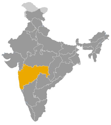
This map illustrates the maximum territory that the Bhonsle of Akkalkot Dynasty had reached at its height, covering the current regions of Maharashtra in India. Its main purpose is to provide a visual aid to understand the geographical extent of this dynasty. However, it's important to note that the contemporary borders of these regions may not necessarily coincide with the historical territories.
The Bhonsle Dynasty of Akkalkot: Regional Power, Cultural Patronage and Colonial Transformation
Origins within the Maratha Political Order
The Bhonsle dynasty of Akkalkot governed a small territory in the Deccan from 1708 until 1948. Located principally in what is now the Solapur district of Maharashtra, its principality occupied a modest but distinctive place in Indian history. Its significance lies in the consolidation of Maratha authority, the survival of hereditary government under British supremacy and the development of a lasting religious identity.
The dynasty originated with Ranoji Lokhande, whom Shahu, the grandson of Shivaji, adopted around 1708. Renamed Fatehsinh Bhonsle, he received Akkalkot and surrounding lands as a hereditary estate, or jagir. Adoption established a connection with the Maratha royal family and provided political legitimacy. The foundation of Akkalkot therefore reflected the importance of kinship, royal favour and territorial grants in organizing Maratha power.
Territorial Government and Regional Political Significance
Akkalkot initially remained subordinate to the ruler of Satara. Its chiefs administered their domain within a political hierarchy that combined local hereditary authority with obligations to a superior ruler. Such arrangements helped sustain Maratha influence through a network of regional houses.
The Akkalkot dynasty must be distinguished from other Bhonsle branches, particularly those associated with Nagpur and Thanjavur. It did not command their territories or resources. Its possessions were concentrated around Akkalkot, with several detached villages elsewhere in present day Maharashtra.
Its political contribution was consequently regional. The ruling house provided continuity in territorial administration while adapting to changes in the wider balance of power. Akkalkot illustrates how smaller hereditary states formed an important intermediate layer between village society and larger imperial structures.
British Supremacy and the Limits of Princely Autonomy
The collapse of Maratha predominance transformed Akkalkot’s political position. The state entered British protection in 1820. Following the annexation of Satara in 1848, its relationship with the colonial authorities became direct.
The Bhonsles retained their title and an internal administration, but British supremacy constrained their independence. Their position depended on recognition within the colonial political order. Regents and supervising officials could exercise substantial authority, particularly during royal minorities. Between 1866 and 1896, the state was under British administration.
Akkalkot thus exemplified the system of indirect rule that characterized much of colonial India. Hereditary rulers remained visible representatives of local authority, while the British controlled the broader political framework. Dynastic survival did not amount to unrestricted sovereignty, and administrative change cannot be attributed exclusively to the princes themselves.
Agriculture, Textile Production and Changing Trade
Akkalkot’s economy rested primarily on agriculture and land revenue. During the 1880s, the state covered approximately 1,290 square kilometres, including its detached possessions. Revenue from cultivated land supplied a substantial share of public income.
Textile work was another important activity. Weavers and spinners belonged to several communities, while carpenters, smiths and other artisans largely served local demand. Economic life therefore combined agricultural production with household manufacturing and regional commerce.
Railway expansion altered established trading patterns. Traffic formerly carried by merchant caravans between Solapur and neighbouring territories increasingly shifted to rail transport. These changes connected Akkalkot to wider markets while reducing the importance of older transit routes.
The administration also supported basic public services. A dispensary opened in 1871, and nineteen schools were recorded in 1882 and 1883. Such institutions indicate a gradual broadening of governmental responsibilities, although their reach remained limited.
Religious Patronage and the Influence of Swami Samarth
Akkalkot’s most enduring cultural association developed during the nineteenth century through Swami Samarth, a spiritual teacher who settled there in the middle of the century and died in 1878. His followers regard him as a manifestation of Dattatreya.
Devotional accounts describe contacts between Swami Samarth and Maloji Raje Bhonsle, including royal hospitality and assistance. These traditions demonstrate the place of religious patronage in memories of the ruling house. Their miraculous elements, however, belong to religious belief rather than independently established political history.
Swami Samarth’s reputation gave Akkalkot a spiritual importance extending beyond its territorial boundaries. Shrines, pilgrimage and devotional practices became central to the town’s identity. This legacy also depended on disciples and religious institutions, whose contributions should be distinguished from those of the dynasty.
Integration into Independent India and Historical Legacy
Akkalkot acceded to independent India in 1947 and merged into Bombay on 8 March 1948, ending dynastic government.
The Bhonsles of Akkalkot left a predominantly regional legacy. Their history connects Maratha state formation, colonial indirect rule, an agricultural and artisanal economy, and religious patronage. Their experience reveals how a small principality could retain institutional continuity while undergoing profound changes in political authority and economic life.
The Bhonsles of Akkalkot: Territory and Political Relationships in the Deccan
The Establishment of a Maratha Hereditary Domain
The Bhonsle dynasty of Akkalkot governed a small territory in western India from 1708 until 1948. Its geographical history centres on the preservation of a regional principality rather than sustained territorial expansion. Its lands must be distinguished from those of other Bhonsle houses, particularly Nagpur and Thanjavur, which developed separate political and territorial histories.
The dynasty originated with Ranoji Lokhande, adopted around 1708 by Shahu, the grandson of Shivaji. Renamed Fatehsinh Bhonsle, he received Akkalkot and surrounding lands as a hereditary estate, or jagir. This grant established the territorial foundation of the ruling house and placed it within the Maratha political hierarchy under Satara.
Its authority therefore originated in royal recognition. The connection with Shahu provided legitimacy, but did not give Akkalkot control over the wider possessions of the Bhonsle family.
The Territorial Core around Akkalkot
The principal territory lay southeast of Solapur, centred on Akkalkot, the dynastic capital. Nineteenth century descriptions recorded a total area of approximately 1,290 square kilometres. This figure documents the state at a particular period rather than establishing its greatest extent throughout its history.
The central domain contained Akkalkot and settlements including Chapalgaon, Jeur, Karajgi, Mangrul, Nagansur, Tolnur and Vagdari. Seven detached villages supplemented this core: six in the Malshiras subdivision of Solapur and one, Kurla, in the Khatav subdivision of Satara.
These possessions correspond to locations in present day Maharashtra. The state was therefore geographically limited, although its scattered holdings made its administrative structure more complicated than a single continuous block of territory.
Fragmented Frontiers and Neighbouring Ruling Houses
Nineteenth century accounts placed Akkalkot beside territories belonging to the nizam of Hyderabad, possessions of the Patvardhan houses, and the administrative subdivisions of Solapur and Indi. The Bhima River and, for a short distance, the Sina formed sections of its boundaries.
This setting brought Akkalkot into contact with different political authorities. Hyderabad represented a major regional monarchy, while the Patvardhans governed several Maratha principalities. British administered districts formed another part of the surrounding landscape.
Political boundaries did not follow a simple division between Maratha and non Maratha territory. Separate jurisdictions existed close together, and detached villages complicated the pattern further. Managing the domain consequently required attention to relationships beyond the capital, particularly where movement and commerce crossed administrative borders.
Satara and the Legitimacy of Territorial Possession
Satara was initially Akkalkot’s most important political connection. The estate had been established through a royal grant and remained tributary to Satara until 1848. Adoption into the Bhonsle family strengthened the dynasty’s standing within this relationship.
Akkalkot’s territorial rights thus belonged to a hierarchy of hereditary authority and allegiance. Its rulers were neither governors of the entire Maratha realm nor sovereigns over other Bhonsle states.
Neighbouring Patvardhan possessions formed part of the same broader regional environment, but belonged to distinct ruling houses. Their proximity illustrates the fragmented structure of Maratha territorial power. It does not, by itself, establish a history of continuous warfare, annexation or rivalry between Akkalkot and each neighbouring principality.
Hyderabad and the Reorganization of Regional Authority
Contact with Hyderabad placed Akkalkot near an important boundary within the Deccan. Trade connected Solapur with settlements farther east, linking local economic activity to territories beyond the principality.
British ascendancy changed the framework governing these relationships. Akkalkot entered British protection in 1820 while retaining its connection with Satara. After Satara was annexed in 1848, Akkalkot’s relationship with the British authorities became direct.
Its rulers continued to govern a recognized domain, but their diplomatic freedom was increasingly constrained. Relations with neighbouring dynasties now operated within an imperial order that supervised princely authority. Territorial continuity depended less on independent military expansion than on recognition under British supremacy.
Territorial Integration after Indian Independence
Akkalkot acceded to independent India in 1947 and merged into Bombay on 8 March 1948. This ended its existence as a separately governed princely territory. Its former possessions are situated in Maharashtra today.
The geographical significance of Akkalkot lay primarily in its position among larger and smaller neighbouring powers. Its history demonstrates how a modest hereditary domain could survive through changing relationships with Satara, Hyderabad, other Maratha houses and the British, before becoming part of the territorial structure of independent India.
The rulers bore the title of raja. Akkalkot was subordinate to Satara and came under British protection in 1820. The dates indicate dynastic succession rather than uninterrupted personal government. Regencies and administrative restrictions are specified below. Some dates differ between chronologies, particularly the restoration of personal government to Shahaji III. The list ends with the state's merger into Bombay on 8 March 1948; subsequent holders of the dynastic title alone are excluded.
- Fatehsinh Rao I Bhonsle (1708–1760) • Founded the house of Akkalkot after receiving a hereditary estate from Shahu.
- Shahaji Rao I Bhonsle (1760–1789) • Succeeded Fatehsinh I as head of the estate subordinate to Satara.
- Fatehsinh Rao II Bhonsle (1789–1822) • His reign saw Akkalkot come under British protection in 1820.
- Maloji Rao I Bhonsle (1822–1828) • Ruled Akkalkot under British protection while retaining its connection with Satara.
- Shahaji Rao II Bhonsle (1828–1857) • Initially reigned under a regency until 1838. Following Satara's annexation in 1848, Akkalkot came under direct British supervision.
- Maloji Rao II Bhonsle (1857–1870; personal ruling powers withdrawn in 1866) • Retained his dynastic position after administration passed to the British authorities.
- Shahaji Rao III Bhonsle (1870–1896; personal government from 1891 according to some chronologies) • Succeeded as a minor; administration initially remained under British control.
- Fatehsinh Rao III Bhonsle (1896–1923; under regency until 1916) • Received full ruling powers on 20 August 1916 after a prolonged minority.
- Vijayasingh Rao Bhonsle (1923–8 March 1948; under regency until 1936) • Exercised personal government from 27 February 1936. The last ruling raja before the merger into Bombay.
 Links to the main sections of the site