
 Français (France)
  Nederlands (nl-NL)
 00:00 • intro | 00:43 • Balige market | 01:57 • the thermal springs of Sipoholon | 03:36 • some rice fields | 04:52 • A village ... (Angkola Timur) | 05:37 • Minangkabau country | 07:20 • a Minangkabau dance performance | 13:01 • a waterfall
Personal creation from visual material collected during my trip Indonesia • Sumatra, Java and Bali (2019)
Map of places or practices featured in the video
• Use the markers to explore the content •
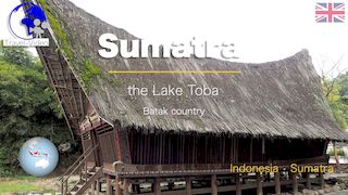
From Lake Toba to the Minangkabau Highlands: Landscapes and Traditions of Sumatra
A cultural and natural journey across northern and western Sumatra
This video follows a route across several regions of Sumatra, from the surroundings of Lake Toba to the Minangkabau highlands of western Indonesia. Markets, thermal springs, rice fields, villages, traditional dance, and mountain landscapes appear throughout the journey, creating a broader portrait of one of the largest and most geographically diverse islands of the Indonesian archipelago.
The film combines scenes of rural life with environments shaped by volcanic activity and long-established cultural traditions. Agricultural landscapes, local communities, and regional performances reveal aspects of Sumatra that remain closely connected to traditional social structures and to the mountainous environment that dominates much of the island.
The progression toward the Minangkabau region also introduces one of the most distinctive cultural groups of western Indonesia. Through dance, village life, and landscapes, the video presents Sumatra not only as a territory of volcanic scenery and rural agriculture, but also as a region marked by strong regional identities and enduring cultural practices.
Markets, villages and landscapes around Lake Toba
The first part of the video focuses on the northern region surrounding Lake Toba, beginning with scenes filmed at the market of Balige. Markets of this type remain central to economic exchange and social interaction in many parts of rural Sumatra. Agricultural products, textiles, and everyday goods visible in the market reflect the local economy of the highland communities surrounding the lake.
The route then continues toward the Sipoholon Hot Springs, known for their geothermal activity and mineral formations. The pale mineral deposits and steaming waters illustrate the volcanic and tectonic character of this region of Sumatra, located within one of the most geologically active zones of Indonesia.
Several sequences also show rice fields integrated into mountain valleys and cultivated slopes. These agricultural landscapes demonstrate the importance of rice cultivation in rural Sumatra and the adaptation of farming systems to uneven volcanic terrain. Terraced fields, irrigation channels, and isolated settlements create landscapes strongly shaped by both environmental conditions and long-term agricultural practices.
Scenes filmed in the village area of Angkola Timur provide another perspective on everyday life in the region. Roads, houses, cultivated land, and small settlements reveal communities still closely linked to local agricultural activity and regional traditions.
The Minangkabau region and cultural traditions of western Sumatra
The second part of the journey moves toward the Minangkabau region of western Sumatra, an area known for its distinctive social organization and cultural traditions. The Minangkabau people are particularly recognized for their matrilineal social system, commercial traditions, and architecture characterized by sharply curved rooflines resembling buffalo horns.
The video includes a performance of Minangkabau Dance, illustrating the importance of movement, rhythm, and ceremonial performance within regional culture. Costumes, choreography, and musical accompaniment reveal traditions transmitted through generations and still actively practiced today. Some dance forms also incorporate gestures influenced by local martial arts traditions, especially pencak silat, which remains closely associated with Minangkabau identity.
The cultural performances visible in the film demonstrate how regional traditions continue to occupy a visible place in contemporary Indonesian society, both during ceremonial events and within cultural presentations intended for visitors and local audiences.
The mountain landscapes of western Sumatra strongly contribute to the identity of the region. Roads pass through valleys, forested slopes, agricultural areas, and villages that remain closely connected to the surrounding volcanic environment. The presence of a waterfall in the final sequences further emphasizes the abundance of water resources generated by heavy rainfall and mountainous terrain.
Together, these scenes present western Sumatra as a region where natural geography continues to influence settlement patterns, agriculture, transportation, and cultural life.
What the videos on this site make particularly easy to observe
The animated photographic sequences used throughout the video allow viewers to examine the landscapes and cultural details of Sumatra with particular clarity. Gradual visual transitions make the volcanic reliefs, rice fields, and geothermal formations around Sipoholon easier to understand than rapidly edited footage would allow.
This approach is equally effective for observing village life and cultural performances. Traditional costumes, dance gestures, musical rhythms, and local architectural details remain visible long enough to encourage careful observation and comparison between different environments.
The agricultural landscapes also become easier to interpret through the progressive movement within the photographs. Terraced rice fields, mountain valleys, and the relationship between settlements and cultivated land can be followed step by step throughout the journey.
The visual structure of the video further connects several dimensions of Sumatra within a coherent narrative: geothermal activity, agriculture, village life, regional identity, and cultural performance all appear as interconnected aspects of the same territory.
Between volcanic landscapes and living regional traditions
This journey from Lake Toba to the Minangkabau region presents Sumatra as a territory where volcanic geography, rural life, and regional cultural traditions remain deeply interconnected. Markets, rice fields, villages, dances, waterfalls, and geothermal landscapes together form a portrait of an island where environmental conditions and cultural identity continue to shape everyday life across different regions of Sumatra.
Links to related pages
Videos
• Indonesia •


Audio Commentary Transcript
To go from Lake Toba, land of the Batak to that of the Minangkabau, you pass through towns and villages where you meet friendly people, even if these places have few tourist attractions. Rice fields also attract attention and a little wonder a little hidden away from the road, the hot springs of Sipoholon.

Music:
- - YouTube video library - Anamalie, (© Anamalie by Kevin MacLeod is licensed under a Creative Commons Attribution 4.0 license. https://creativecommons.org/licenses/by/4.0/
- Source: http://incompetech.com/music/royalty-free/index.html?isrc=USUAN1500007
- Artist: http://incompetech.com/)
- - YouTube video library - Argonne - Zachariah Hickman
- - YouTube video library - Clouds
Disclaimer: Despite its appropriateness, copyright issues prevent the use of indonesian traditional music in "Indonesia • Sumatra • from Toba lake to Minangkabau land", hence the use of royalty-free music. Despite our careful selection, some might regret this decision, which is necessary to avoid potential lawsuits. Although difficult, this decision is the only viable solution.


