Français (France)
  Nederlands (nl-NL)
 00:00 • intro | 00:25 • the Chao Phraya River | 01:27 • after the big river, here are the peaceful khlong
Personal creation from visual material collected during my trip Laos and Bangkok (2022)
Map of places or practices in Bangkok on this site
• Use the markers to explore the content •
Bangkok Between the Royal River and the Khlong Network
A Capital Shaped by Water
Bangkok developed across a broad delta plain where water long determined transport, settlement patterns and economic life. Before the expansion of modern roads, the city moved largely to the rhythm of the Chao Phraya River and the many canals known as khlongs. This video explores that essential relationship between a major Asian capital and its aquatic landscape.
Far more than scenery, river and canals helped organize the city itself. They linked neighbourhoods, markets, temples and agricultural zones while serving as practical routes for movement and trade. Even today, these waterways retain strong cultural and visual importance, revealing a side of Bangkok very different from expressways and high-rise districts.
From the Chao Phraya to the Quieter Canals
The opening sequences on the Chao Phraya present the main axis around which Bangkok emerged as a political and commercial centre. Wide, active and constantly used, the river remains one of the city’s great arteries, carrying ferries, commuter boats and local traffic between both banks.
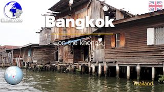
After this broad river, the video turns toward the quieter khlongs. Here the scale changes immediately. Movement slows, the banks draw closer, and Bangkok appears in a more intimate form. Waterside houses, small boats, tropical vegetation and modest footbridges create an environment where older patterns of daily life remain visible.
This transition from principal river to residential canals helps explain the hydraulic diversity of Bangkok and the many ways water continues to shape urban space.
Urban History and the Role of the Khlongs
The khlongs played a central role in the history of the Siamese and later Thai capital. Some were dug for defence, others for drainage, irrigation or communication. For long periods, travel by boat was often easier than overland movement, especially during the rainy season.
The old description of Bangkok as the “Venice of the East” simplifies reality, yet it reflects how strongly foreign visitors associated the city with waterways. During the twentieth century, many canals were filled or reduced in importance as roads expanded. Even so, several districts preserved their khlong networks, which remain part of the city’s memory and practical water management.
They also continue to support everyday activities such as local transport, floating trade, riverside living and small-scale fishing.
What the Video Makes Especially Clear
Videos built from carefully selected and animated photographs are especially effective for water-based urban landscapes. They make it easier to compare the broad scale of the Chao Phraya with the narrowness of secondary canals and to observe how the city changes according to the width of the waterway.
Image transitions also reveal details often missed during a fast visit: timber or concrete embankments, lines of houses, reflections, moored boats, riverside vegetation and the relationship between homes and water level. Viewers gradually understand that Bangkok grew around a network rather than around a single avenue or central square.
This format also conveys changing atmospheres, from the energy of the main river to the relative calm of canal neighbourhoods.
Another View of Bangkok
This journey along the Chao Phraya and through the khlongs reveals a capital whose identity extends far beyond towers and traffic. Bangkok still preserves a visible aquatic heritage in its canals and inhabited waterfronts. The video offers a valuable perspective on the city, while the related detailed pages provide further insight into the history and continuing role of the khlongs in the Thai metropolis.
Links to related pages
Videos
• Thailand •


Audio Commentary Transcript
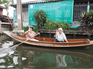
While the Chao Phraya River defines Bangkok's landscape, it's the khlongs, the historical canals, that earned the city its nickname "Venice of the East". Once crucial to the local economy for transport and trade, these canals have largely lost their economic significance over time. Today, they attract more tourists seeking picturesque experiences than local traders, reflecting a shift from a vital function to a primarily tourist attraction.
In the presence of the neighborhood's tranquility, with locals rowing gently on their small boats, one might question the choice of tourist boat operators to install large and noisy engines on their vessels. It seems that necessities related to the river's flow and the congestion in Bangkok's waterways have led to the preference for powerful boats.
There is no doubt that these other residents would also have appreciated a little more calm.
Once, Bangkok's network of canals was the bustling heart of its economic life, but today, only a fraction of this aquatic maze remains. The relentless march of modernity, with its demand for quicker communication routes, has led to many khlongs being filled in, replaced by asphalt roads and the rise of new residential areas. However, some now reflect wistfully on the functional role these canals once played, especially in flood management. The homes that still line these waters present a striking contrast: some exhibit remarkable preservation, while others show significant signs of wear. And, true to Thai spirit, the area is dotted with temples, adding a spiritual dimension to its landscape.

Music:
- - YouTube video library - Familiar Things
- - YouTube video library - Wonder
Disclaimer: Despite its appropriateness, copyright issues prevent the use of thai traditional music in "Bangkok, boat trip on the khlongs • Thailand", hence the use of royalty-free music. Despite our careful selection, some might regret this decision, which is necessary to avoid potential lawsuits. Although difficult, this decision is the only viable solution.