
 Français (France)
  Nederlands (nl-NL)
 The Southwest Decumanus in Jerash, Jordan, forms one of the principal urban axes of the ancient city of Gerasa. This east–west thoroughfare structured the organization of public space and connected several districts within the settlement. It was part of the orthogonal street grid typical of Roman cities in the Near East. Lined with colonnades and associated with major public buildings, the street played a central role in circulation, trade, and civic activities. Today, the Southwest Decumanus remains a key component of the archaeological site of Jerash and provides insight into the city’s urban planning during the Roman period.
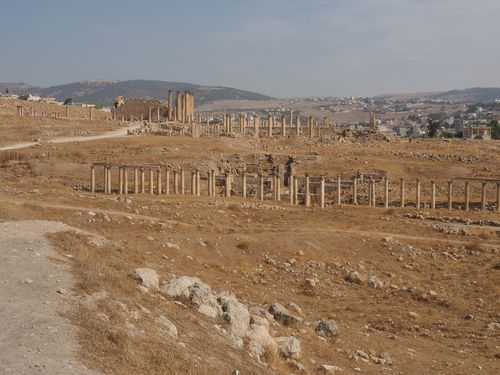
Jerash • Decumanus South-West
Jerash • Decumanus South-West
Jerash • Decumanus South-West
Monument profile
Decumanus South-West
Monument categories: Archaeological, Main thoroughfare
Monument families: Archaeological • Civil engineering structures (bridges, wells, etc.) and factories
Monument genres: Archaeological site, Economic
Cultural heritage: Roman antiquity
Geographic location: Jerash • Jordan
Construction period: 1er siècle
• Links to •
• List of videos about Amman, Jerash, Umm Qais on this site •
Jordan • the Roman Jordan
Jerash, Pompeii of the East • Jordan
The Southwest Decumanus of Jerash: Historical Development and Urban Significance
The Southwest Decumanus of Jerash, ancient Gerasa, formed one of the principal east–west arteries of the Roman city. More than a thoroughfare, it represented a deliberate statement of urban order, political allegiance, and civic ambition. Its history reflects the transformation of Gerasa from a Hellenistic settlement to a flourishing Roman provincial city, later integrated into Byzantine and Islamic political frameworks before entering a long period of decline and eventual archaeological rediscovery.
Political and Social Context of Construction
Gerasa was part of the Decapolis, a network of predominantly Hellenized cities in the eastern Mediterranean that retained a degree of autonomy under Roman rule. After the annexation of the Nabataean Kingdom in 106 CE by Emperor Trajan and the creation of the province of Arabia Petraea, the region underwent intensified administrative and infrastructural development. The establishment or monumental reinforcement of the decumanus must be understood within this broader reorganization.
Roman urban planning emphasized orthogonal street grids, with the decumanus maximus serving as the primary east–west axis intersecting the north–south cardo. In Gerasa, the Southwest Decumanus was integrated into this rational scheme, aligning civic spaces and facilitating circulation. Its construction or enhancement in the 2nd century CE coincided with a period of relative stability and economic prosperity across the eastern provinces of the Empire.
The motivations behind such urban works were both practical and symbolic. On a practical level, the street organized commercial, administrative, and social life. On a symbolic level, it signaled Gerasa’s loyalty to Rome and its participation in imperial culture. Local elites—wealthy landowners, merchants, and civic magistrates—invested in urban embellishment to assert status and reinforce alliances with imperial authorities. Competition among Decapolis cities likely stimulated the construction of monumental streets, colonnades, and public buildings as markers of prestige.
Major Historical Events Affecting the Site
During the High Roman Empire, particularly in the 2nd and early 3rd centuries CE, Gerasa reached the height of its prosperity. Monumental construction, including temples, theaters, and bath complexes, framed the Southwest Decumanus. The street became a ceremonial route, accommodating civic processions and religious gatherings.
The 3rd century CE brought political instability throughout the Roman world. Although Gerasa did not experience large-scale destruction comparable to frontier cities under direct military threat, imperial crises affected trade networks and public finances. Nonetheless, the urban core continued to function, and modifications to existing infrastructure were undertaken.
In the late Roman and early Byzantine periods, Christianity gradually reshaped the city’s religious landscape. Churches were constructed within the urban grid, sometimes near major thoroughfares. The Southwest Decumanus remained active but adapted to new liturgical and social functions. Certain adjacent structures were repurposed, and maintenance of colonnades may have declined as civic priorities shifted.
The decisive turning point came in the 7th century with the Islamic conquest of the Levant. Gerasa was incorporated into the Umayyad Caliphate. While the city retained a measure of continuity, economic gravity shifted toward other centers. The catastrophic earthquake of 749 CE severely damaged the urban fabric. Many colonnades collapsed, and the decumanus lost its monumental coherence. Subsequent centuries saw progressive abandonment and reuse of building materials.
Global Context of Monumental Urbanism
The Southwest Decumanus must be situated within the broader framework of Roman imperial urbanism. Across the Mediterranean basin, cities were reorganized or founded according to standardized planning principles. Colonnaded streets became a hallmark of eastern provincial cities, particularly in Syria and Arabia.
At the time of Gerasa’s development, cities such as Palmyra, Antioch, and Apamea also featured monumental avenues lined with columns. This phenomenon reflected not only aesthetic preferences but also administrative rationalization and integration into imperial trade networks. Gerasa’s participation in this movement underscores its connectivity to broader Mediterranean dynamics.
Beyond the Roman world, comparable processes of monumental construction were occurring in Parthian and later Sasanian territories, as well as in parts of the Han Empire in East Asia. Although direct architectural influence was limited, these parallel developments indicate a global era of urban intensification and state-sponsored monumental expression.
Transformations Through the Centuries
Architectural modifications accompanied changing political realities. During the Byzantine period, some sections of the street were narrowed or partially obstructed by new constructions. Maintenance regimes evolved, and decorative elements were simplified or dismantled.
Following the 749 earthquake, large portions of the decumanus were left in ruin. Stone blocks were quarried for later building projects in the surrounding region. The once continuous colonnades became fragmented. Over time, sediment accumulation and limited rural occupation covered much of the ancient city.
European travelers in the 19th century documented extensive ruins. Systematic archaeological excavations in the early 20th century revealed the original urban grid. Restoration efforts sought to re-erect fallen columns through anastylosis, reusing original materials where possible. These interventions restored legibility to the decumanus while preserving archaeological integrity.
Modern Role and Cultural Significance
Today, the Southwest Decumanus is a central feature of the archaeological site of Jerash, one of the best-preserved Roman provincial cities in the Near East. It plays a significant role in Jordan’s cultural heritage narrative, illustrating the country’s multi-layered history.
The street serves as a backdrop for cultural events, notably the Jerash Festival of Culture and Arts. Although no longer a functional civic artery, it remains a symbolic axis around which contemporary cultural identity is articulated. Its presence reinforces Jordan’s positioning as a crossroads of civilizations.
Jerash has been included on Jordan’s tentative list for UNESCO World Heritage inscription. Such recognition would formalize its international importance and impose additional conservation standards. The decumanus, as a defining structural element of the site, would be central to any future nomination dossier.
Conservation Status and Contemporary Challenges
The Southwest Decumanus faces ongoing conservation challenges. Environmental factors, including temperature fluctuations and seasonal rainfall, contribute to material deterioration. The region’s seismic activity remains a latent threat.
Tourism presents both opportunities and risks. High visitor numbers generate economic benefits but also accelerate wear on stone pavements. Conservation policies implemented by the Department of Antiquities of Jordan emphasize structural stabilization, monitoring, and controlled restoration.
Urban expansion in the modern city of Jerash has increased pressure on the archaeological perimeter. Protective zoning measures seek to buffer the ancient remains from encroachment. International collaborations have supported documentation and conservation, ensuring adherence to contemporary heritage management standards.
Conclusion
The Southwest Decumanus of Jerash embodies the intersection of Roman urban ideology, provincial ambition, and subsequent historical transformation. Conceived as a monumental axis reflecting imperial order and civic pride, it endured political transitions, religious shifts, natural disasters, and centuries of neglect. Its rediscovery and preservation have restored its significance as both an archaeological landmark and a cultural symbol. As part of Jerash’s broader urban ensemble, it continues to illuminate the dynamics of ancient urban life and the enduring legacy of Roman planning in the eastern Mediterranean.
Architectural features
Architecture of the Southwest Decumanus of Jerash
The Southwest Decumanus of Jerash constitutes one of the principal east–west arteries of the ancient city of Gerasa. Its architectural configuration reflects the mature phase of Roman provincial urbanism in the Near East, combining standardized planning principles with local materials and regional craftsmanship. Far from being a simple paved street, the decumanus functioned as an integrated architectural system composed of carriageway, colonnaded porticoes, drainage infrastructure, and coordinated façades. Its design demonstrates technical precision, structural foresight, and an aesthetic program aligned with imperial models while adapted to the environmental and seismic realities of northern Jordan.
Urban Layout and Spatial Organization
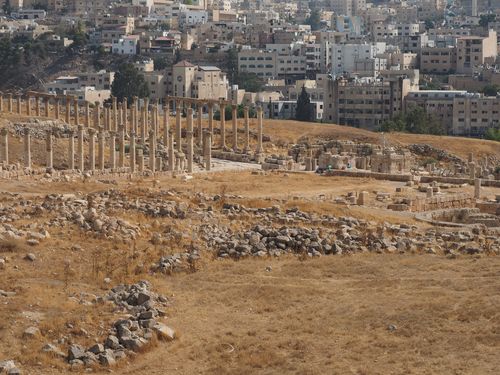
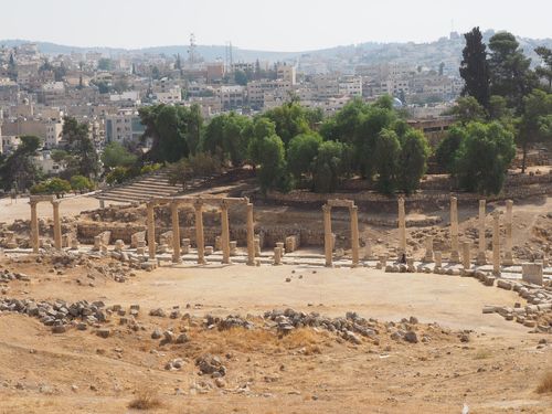
The Southwest Decumanus follows a rectilinear east–west alignment consistent with the orthogonal grid characteristic of Roman colonial planning. It intersects secondary streets at right angles, reinforcing the geometric clarity of the city’s plan. The preserved width averages approximately 14 to 16 meters, including sidewalks and colonnades, placing it among the broader examples of Roman provincial streets.
The central carriageway, originally paved with large limestone slabs, occupies roughly 7 to 8 meters in width. Flanking it are raised sidewalks designed for pedestrian circulation. These sidewalks are fronted by continuous colonnades, forming sheltered porticoes that provided protection from sun and seasonal rainfall. The rhythmic repetition of columns establishes a strong longitudinal perspective, visually elongating the axis and enhancing its ceremonial character.
The spacing between columns averages approximately 3.5 meters, creating modular bays that accommodated shop entrances and access points to adjacent buildings. This regular interval reflects precise measurement systems, likely based on Roman foot modules, ensuring proportional consistency across the urban frontage.
Construction Techniques and Engineering Solutions
The construction of the Southwest Decumanus demonstrates advanced Roman road engineering adapted to urban conditions. Beneath the visible paving, the substructure consisted of multiple compacted layers: a prepared soil bed, a foundation of rubble and gravel for load distribution, and a leveling layer supporting the limestone paving slabs. This stratification minimized settlement and increased durability.
The limestone slabs were carefully cut and fitted with minimal joints. Some sections display evidence of dowel holes or clamps used to stabilize adjacent stones. The surface exhibits slight cambering—an intentional convex curvature—to facilitate water runoff toward lateral drainage channels.
The colonnades were assembled from stacked limestone drums, joined by metal dowels or stone tenons inserted into central pivot holes. This drum construction method provided both vertical stability and limited flexibility under seismic stress. In a region historically affected by earthquakes, this structural articulation was essential. The modular nature of column drums also allowed replacement or repair without dismantling entire sections.
Drainage was integral to the architectural conception. Covered channels ran parallel to the sidewalks, connected to subterranean conduits that diverted stormwater beyond the urban core. Stone slabs with perforations or narrow slots allowed surface water to enter the drainage system while maintaining pedestrian continuity. Such integrated hydraulic planning prevented erosion of paving and foundation.
Materials and Structural Performance
Local limestone served as the primary building material. Its availability reduced transport costs and facilitated large-scale extraction. The stone’s workable texture permitted detailed carving for capitals and architectural moldings while maintaining sufficient compressive strength for structural components.
The use of locally quarried limestone influenced both aesthetics and performance. The pale coloration reflected sunlight, reducing heat absorption along the street surface. However, limestone’s porosity rendered it vulnerable to weathering, especially under fluctuating temperature and humidity conditions. The long-term survival of numerous columns demonstrates both the material’s resilience and the precision of its quarrying and dressing.
Occasional use of imported marble elements—particularly in decorative features—suggests selective embellishment for visual hierarchy. These insertions reinforced the symbolic status of the decumanus as a prestigious civic axis.
Architectural and Artistic Influences
The colonnaded street typology emerged from Hellenistic urban traditions and was refined under Roman administration. In the eastern provinces, monumental avenues lined with Corinthian columns became defining features of cities such as Apamea and Palmyra. The Southwest Decumanus belongs to this architectural lineage while maintaining proportional characteristics specific to Gerasa.
The predominance of Corinthian capitals aligns with imperial aesthetic norms. Their acanthus leaf carvings display variations that indicate local workshops adapting classical motifs. The sculptural vocabulary combines standardized Roman forms with subtle regional stylization in leaf curvature and volute articulation.
Entablatures and architraves above the columns likely supported wooden roofing elements or partial coverings. Although no complete superstructure survives, socket traces and beam supports indicate that certain sections may have incorporated timber frameworks to enhance shading.
Structural Particularities
One distinguishing feature is the exceptional continuity of alignment across long stretches. The precise leveling and uniform elevation of the stylobates suggest coordinated surveying. Minor gradient adjustments along the axis accommodated topographical variations while preserving overall linear coherence.
Wheel ruts visible in certain paving slabs provide evidence of sustained vehicular traffic. Their consistent depth indicates long-term functional use rather than purely ceremonial application. The integration of vehicular and pedestrian zones demonstrates practical urban design rather than purely monumental staging.
Another notable characteristic is the slight inward tilt observed in some re-erected columns, resulting from seismic events and subsequent restorations. Modern conservation efforts have stabilized these elements using minimally invasive anchoring techniques.
Dimensions and Quantitative Aspects
The preserved length of the Southwest Decumanus extends several hundred meters, though its original extent was likely longer. Individual columns reach heights of approximately 6 to 7 meters, excluding capitals. The diameter of column shafts averages around 0.7 to 0.9 meters at the base.
The original number of columns along the entire stretch likely exceeded one hundred on each side, forming a monumental corridor. Such scale reinforced the visual rhythm and civic prominence of the axis.
An often overlooked detail is the slight elevation difference between carriageway and sidewalk, typically around 20 to 30 centimeters. This subtle separation organized circulation patterns and prevented water accumulation on pedestrian surfaces.
Modifications and Later Interventions
Over time, architectural modifications reflected shifting priorities. In the Byzantine period, some portico sections may have been enclosed or partially dismantled to accommodate new structures. Earthquake damage in the 8th century caused widespread column collapse, leaving fragments scattered across the pavement.
Modern archaeological restoration has reassembled numerous columns using anastylosis, repositioning original drums and supplementing missing segments with discreet supports. These interventions prioritize structural safety while preserving historical authenticity.
International Significance and Conservation
The architectural coherence of the Southwest Decumanus contributes significantly to Jerash’s global recognition as one of the most complete Roman provincial urban ensembles. The street exemplifies the transfer and adaptation of Roman engineering principles across the empire.
Today, the monument is protected under Jordanian heritage legislation. Conservation challenges include limestone erosion, visitor-induced wear on paving slabs, and microfractures resulting from past seismic activity. Preventive conservation strategies involve regular monitoring, drainage maintenance, and restricted vehicular access.
Urban expansion near the archaeological zone has required buffer management to prevent structural stress from modern infrastructure. Conservation programs emphasize reversible interventions and documentation of original fabric.
Architectural Assessment
The Southwest Decumanus stands as a comprehensive example of Roman urban engineering applied in a provincial context. Its architecture integrates geometric planning, modular construction, hydraulic foresight, and sculptural articulation into a unified civic axis. The technical decisions—layered road foundations, articulated column drums, calibrated drainage gradients—demonstrate deliberate adaptation to local environmental and seismic conditions.
Beyond its function as a thoroughfare, the street operated as a structured architectural corridor. Its measured proportions, repetitive colonnades, and integrated infrastructure underscore a sophisticated understanding of spatial organization and material performance. The Southwest Decumanus thus embodies the synthesis of imperial urban standards and regional execution, preserving a tangible record of Roman architectural logic in the eastern Mediterranean.