

 Français (France)
  Nederlands (nl-NL)
 Of Hindu tradition, (with additional Jain influence), the Chaulukya Solanki dynasty ruled for approximately 304 years, ± between 940 and 1244 over all or part of Central India, North India and West India, during the Classical Period and the Medieval Period.
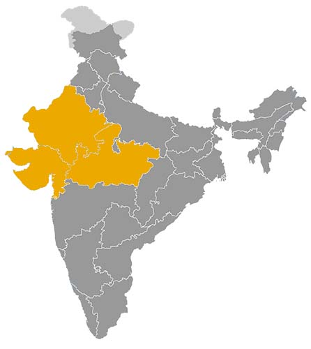
This map illustrates the maximum territory that the Chaulukya Solanki Dynasty had reached at its height, covering the current regions of Gujarat, Madhya Pradesh and Rajasthan in India. Its main purpose is to provide a visual aid to understand the geographical extent of this dynasty. However, it's important to note that the contemporary borders of these regions may not necessarily coincide with the historical territories.
The Chaulukya Solanki Dynasty and the Rise of Medieval Gujarat
A regional power that shaped western India
The Chaulukya Solanki dynasty, also known as the Chaulukyas of Gujarat or the Solankis, played a major role in the history of western India between the tenth and thirteenth centuries. Their political centre was Anahilapataka, modern Patan, in northern Gujarat. From this capital, the dynasty built a powerful kingdom that influenced Gujarat, Saurashtra, parts of Rajasthan, Malwa and the western coastal region.
The dynasty was founded by Mularaja I, who replaced the earlier Chavda rulers of Anahilapataka and established a new political order in Gujarat. His successors transformed this regional base into one of the most influential kingdoms of medieval western India. The importance of the Chaulukya Solankis lies not only in their military expansion, but also in their patronage of architecture, religious institutions, trade networks and regional administration.
A political force between Rajasthan, Malwa and the western coast
The Chaulukya Solanki kingdom occupied a strategic position between several important regions. To the north and north-east lay the Rajput powers of Rajasthan, including the Chahamanas or Chauhans. To the east stood Malwa, often associated with the Paramaras. To the west and south-west lay Saurashtra and the Arabian Sea coast, with its ports, sanctuaries and commercial links.
This location made the Solankis one of the principal powers of western India. Their rulers had to manage relations with neighbouring dynasties through warfare, alliances, diplomacy and control over frontier zones. Under Jayasimha Siddharaja, the kingdom reached one of its greatest phases of political strength. His campaigns extended Chaulukya influence toward Rajasthan, Saurashtra and Malwa, and his reign became associated with royal ambition and territorial prestige.
Kumarapala continued this high point of Solanki power. His reign is often remembered for political stability, religious patronage and the consolidation of royal authority. Later, however, the dynasty faced growing pressure from regional rivals and from powers advancing from the north-west. During the long reign of Bhima II, royal authority weakened, and powerful Vaghela ministers and chiefs gradually became the real holders of political power.
A kingdom structured through ministers, local elites and religious institutions
The Chaulukya Solanki state was not a centralized kingdom in the modern sense. Its authority depended on the king, but also on ministers, military chiefs, local aristocratic families, merchants and religious institutions. This structure allowed the dynasty to govern a varied territory that included agricultural plains, semi-arid zones, fortified towns, coastal regions and temple centres.
The growing influence of the Vaghelas during the later Solanki period illustrates this political structure. They first emerged within the Chaulukya system as powerful subordinates before eventually replacing the dynasty. This transition shows that the Solanki kingdom provided a framework in which regional elites could gain influence, accumulate resources and eventually challenge royal authority.
Land grants, temple patronage and alliances with merchant communities helped integrate local society into the political order. The state relied not only on military power, but also on ritual legitimacy, fiscal control and cooperation with influential groups.
A major age of temple architecture and hydraulic monuments
The cultural legacy of the Chaulukya Solankis is especially visible in architecture. Their period saw the development of a refined architectural style in Gujarat and western India, often associated with richly carved temples, stepwells, reservoirs and sacred complexes. This style combined structural precision, elaborate ornamentation and a close relationship between religion, water management and royal prestige.
The Sun Temple at Modhera is one of the most famous monuments associated with the Solanki period. Its arrangement, sculptural programme and ceremonial tank express the connection between sacred space, cosmic symbolism and royal patronage. Rani ki Vav at Patan is another outstanding example of the period’s artistic achievement. As a stepwell, it had a practical hydraulic function, but its sculptural richness also transformed it into a monumental sacred space.
These constructions show that Solanki patronage was not limited to temples in the narrow sense. Water architecture, reservoirs and stepwells were essential in Gujarat’s climate and became major expressions of artistic and political identity.
Religious patronage and the prominence of Jainism
The Chaulukya Solanki period was marked by the coexistence of several religious traditions. Hindu temples received royal and aristocratic support, but Jainism also gained exceptional prominence, especially under Kumarapala. The scholar Hemachandra, closely associated with Kumarapala’s court, became one of the most important intellectual figures of medieval Gujarat.
Jain communities played an important role in the cultural and economic life of the region. Their links with trade, urban society and temple patronage strengthened the connection between religion and commerce. Solanki support for religious institutions therefore served multiple purposes. It expressed piety, reinforced royal legitimacy, supported learned culture and strengthened ties with influential social groups.
Economic prosperity based on trade, agriculture and urban networks
The economy of the Chaulukya Solanki kingdom benefited from Gujarat’s geographic position. The region was connected to inland trade routes and to maritime networks of the Arabian Sea. Ports on the western coast linked Gujarat with the Persian Gulf, Arabia and the wider Indian Ocean commercial world. Merchant communities contributed to urban prosperity and to the financing of religious and architectural projects.
Agriculture remained another essential foundation of the kingdom. The plains of Gujarat supported land revenue, while irrigation structures, tanks and stepwells helped manage water in a region marked by seasonal variation. The Solanki period therefore linked economic development with hydraulic architecture and religious patronage.
Cities such as Patan functioned as political, commercial and cultural centres. Their prosperity supported the court, temples, artisans, scribes and merchant groups. This combination of agrarian wealth, trade and urban activity made Gujarat one of the most dynamic regions of medieval India.
A lasting foundation for Gujarat’s historical identity
The Chaulukya Solanki dynasty declined in the thirteenth century as effective power passed to the Vaghelas and external pressures increased. Yet its historical role remained significant. The dynasty strengthened Gujarat as a major political region, supported one of the most distinctive architectural traditions of western India, and encouraged religious and intellectual life.
Its legacy continued through the monuments of Patan, Modhera and other sites, as well as through the political structures inherited by later rulers. The Chaulukya Solankis stand as one of the formative dynasties of medieval Gujarat, linking regional kingship, maritime commerce, religious patronage and architectural innovation in the history of western India.
The Geographic Expansion of the Chaulukya Solanki Dynasty in Western India
A kingdom centred on Anahilapataka in northern Gujarat
The Chaulukya Solanki dynasty, also known as the Chaulukyas of Gujarat, ruled one of the most important kingdoms of medieval western India between the tenth and thirteenth centuries. Its political centre was Anahilapataka, modern Patan, in northern Gujarat. From this capital, the Solanki rulers controlled a territory that included the core regions of Gujarat and, at different times, extended its influence toward Saurashtra, Rajasthan, Malwa and the western coast.
The geographic extent of Solanki power was not fixed throughout the dynasty’s history. Like many medieval Indian kingdoms, it consisted of a directly controlled core, dependent territories, allied chiefs and frontier zones where authority could fluctuate. The strongest royal control was exercised in northern and central Gujarat, while peripheral regions were often governed through local elites, tributary rulers or military pressure.
Northern and central Gujarat as the Solanki heartland
The heartland of the Chaulukya Solanki kingdom lay in northern and central Gujarat. Patan, Siddhpur, Modhera and other centres formed the political, religious and economic base of the dynasty. This region provided agricultural revenue, administrative stability and access to important land routes. It also contained many of the monuments that later became associated with the Solanki period.
The control of this heartland allowed the dynasty to support large building projects, including temples, reservoirs and stepwells. These works were not only artistic achievements. They were also instruments of territorial organization, water management and royal prestige. In a region where rainfall could be uneven, the management of water resources had economic and political importance.
From northern Gujarat, the Solankis could project power toward the deserts and hill regions of Rajasthan, the coast of Saurashtra, the plains of southern Gujarat and the routes leading toward Malwa and the Deccan.
Saurashtra and the western coast as strategic zones
Saurashtra was one of the most important regions connected with Solanki expansion. The peninsula had religious, economic and maritime significance. It contained coastal routes, ports, local rulers and major sacred centres, including Somnath. Control over Saurashtra strengthened the kingdom’s access to the Arabian Sea and to the commercial networks of the western Indian Ocean.
The Solankis did not always control Saurashtra in a simple or uniform manner. Local powers, especially the Chudasamas, remained important actors. At different times they could be rivals, subordinates or semi-autonomous chiefs within the wider political sphere of Gujarat. This made Saurashtra both an extension of Solanki authority and a frontier region requiring constant negotiation.
The raid of Mahmud of Ghazni against Somnath during the reign of Bhima I revealed the wealth and vulnerability of the coastal zone. Although the attack had a major symbolic impact, Solanki authority in Gujarat recovered and continued to develop. The event also showed how the geography of Gujarat connected the kingdom not only to Indian regional politics, but also to the wider military movements of the north-west.
Expansion toward Rajasthan and relations with the Chahamanas
To the north and north-east, Solanki influence met the Rajput polities of Rajasthan. Among the most important of these were the Chahamanas, or Chauhans, whose different branches controlled Ajmer, Nadol, Jalor, Chandravati and other strategic centres. The frontier between Gujarat and Rajasthan was not only a political border. It was a zone of trade routes, hill passes, fortified towns and competing aristocratic lineages.
Relations between the Solankis and the Chahamanas alternated between conflict, alliance and rivalry. The branches of Nadol, Jalor and Chandravati were especially relevant because they lay close to the Gujarat frontier and the Aravalli region. Control over these areas affected access between Gujarat, Marwar, Mount Abu and the wider Rajasthan plateau.
This northern frontier gave the Solankis both opportunities and risks. Successful campaigns could extend their prestige deep into Rajasthan, but the strength of local Rajput houses limited the possibility of permanent direct control. The region therefore functioned as a buffer, a battlefield and a diplomatic zone.
Malwa and the rivalry with the Paramaras
To the east and north-east lay Malwa, a powerful region often associated with the Paramara dynasty. Malwa occupied a strategic position between western India, central India and the northern Deccan. Influence there offered access to important inland routes and enhanced royal prestige.
The Solankis, especially under Jayasimha Siddharaja, pursued campaigns and claims toward Malwa. These efforts showed that the dynasty’s ambitions extended beyond Gujarat. However, Malwa was not easily absorbed. The Paramaras had their own strong political identity and territorial base. As a result, Solanki influence in Malwa was usually more episodic than permanent.
The rivalry with the Paramaras shaped the eastern frontier of the Solanki kingdom. It also placed Gujarat within the wider political competition of central and western India.
Southern Gujarat and the routes toward the Deccan
The southern regions of Gujarat connected the Solanki kingdom with the Deccan and with coastal routes leading toward Maharashtra and the Konkan. These territories were important for trade, military movement and contact with powers beyond Gujarat. Control over southern Gujarat helped the Solankis maintain access to both inland and maritime networks.
Their southern frontier was generally less central to their political identity than the northern and eastern rivalries with Rajput and Paramara powers. Nevertheless, it contributed to the economic strength of the kingdom by linking Gujarat to broader commercial circuits and to the western seaboard.
A territorial system based on routes, ports and local powers
The geographic expansion of the Chaulukya Solanki dynasty was closely linked to economic geography. Gujarat contained agricultural plains, inland market towns, pilgrimage centres and ports connected with Arabian Sea trade. Control over these spaces gave the kingdom resources for armies, temples, hydraulic works and courtly institutions.
The Solanki territorial system relied on a combination of royal authority and regional intermediaries. Local chiefs, merchants, temple institutions and ministers all played roles in maintaining the kingdom’s structure. In the later period, the rise of the Vaghelas from within this political system showed that powerful regional actors could eventually replace the dynasty they had served.
The Solanki expansion made Gujarat a major political and economic region of medieval India. Its territory linked inland trade, maritime exchange, sacred centres, frontier fortresses and agricultural wealth. This geography shaped its relations with the Chahamanas, Paramaras, Chudasamas, Deccan powers and forces from the north-west. Through this territorial network, the Chaulukya Solankis helped define the historical identity of medieval Gujarat.
This chronology concerns the Chaulukyas of Gujarat, also known as the Solankis, whose political centre was Anahilapataka, modern Patan. The rulers are generally described as kings in modern historiography, although inscriptions also use honorific sovereign titles such as Maharajadhiraja. The dates are indicative and may vary between scholarly chronologies; during the long reign of Bhima II, effective authority gradually passed to powerful Vaghela ministers and chiefs.
- Mularaja I (c. 941–996 CE) • He founded Chaulukya power in Gujarat after displacing the Chavdas of Anahilapataka.
- Chamundaraja (c. 996–1008 CE) • He consolidated dynastic authority and maintained the kingdom through a phase of political continuity.
- Vallabharaja (c. 1008 CE) • His reign was very brief and remains poorly documented in the available sources.
- Durlabharaja (c. 1008–1022 CE) • He restored stability after the rapid succession that followed Chamundaraja.
- Bhima I (c. 1022–1064 CE) • His reign was marked by Mahmud of Ghazni’s raid on Somnath and by the gradual recovery of Chaulukya authority.
- Karna (c. 1064–1092 CE) • He continued the assertion of the kingdom and is associated in regional tradition with the development of Karnavati.
- Jayasimha Siddharaja (c. 1092–1142 CE) • He raised Chaulukya power to a high level and expanded Gujarat’s influence toward Rajasthan, Malwa and Saurashtra.
- Kumarapala (c. 1142–1172 CE) • He maintained the kingdom at its height and is associated with the patronage of Jainism, architecture and religious institutions.
- Ajayapala (c. 1172–1175 CE) • His brief reign followed the death of Kumarapala and opened a more unstable period.
- Mularaja II (c. 1175–1178 CE) • Still a young ruler, he reigned under strong court influence; tradition connects this period with resistance to a Ghurid attack.
- Bhima II (c. 1178–1240 CE) • His long reign saw the gradual weakening of royal power and the rise of the Vaghelas as holders of effective authority.
- Tribhuvanapala (c. 1240–1244 CE) • Generally recognized as the last Chaulukya king, he ruled when real power had already largely passed to the Vaghelas.