
 Français (France)
  Nederlands (nl-NL)
 The Forum of Jerash in Jordan is one of the most distinctive public spaces of ancient Gerasa, a prominent city of the Decapolis. Characterized by its oval shape, it functioned as a central gathering and circulation area connecting the city’s principal monumental streets. The space hosted civic, commercial, and ceremonial activities, reflecting the urban organization and social dynamics of the city in antiquity. Today, the Forum stands as a key component of the archaeological site of Jerash and provides insight into the functioning of Greco-Roman urban centers in the Near East.
Jerash • Forum
Jerash • Forum
Jerash • Forum
Monument profile
Forum
Monument categories: Archaeological, Iconic square
Monument families: Archaeological • Civil engineering structures (bridges, wells, etc.) and factories
Monument genres: Archaeological site, Economic
Cultural heritage: Roman antiquity
Geographic location: Jerash • Jordan
Construction period: 1er siècle
• Links to •
• List of videos about Amman, Jerash, Umm Qais on this site •
Jordan • the Roman Jordan
Jerash, Pompeii of the East • Jordan
History of the Forum of Jerash
The Forum of ancient Gerasa, modern Jerash in Jordan, stands as one of the most distinctive civic spaces of the Roman Near East. Constructed during the period of Roman imperial prosperity, most likely in the second century CE, the Forum formed part of an ambitious urban development program that reshaped Gerasa into a monumental city of the Decapolis. Its history reflects the political integration of the region into the Roman Empire, the evolution of civic identity, the transformation brought by Christianity and Islam, and the gradual shift from active urban center to archaeological landscape.
Political and Social Context of Construction
In 106 CE, the Roman Empire annexed the Nabataean Kingdom, incorporating its territories into the province of Arabia under Emperor Trajan. Gerasa, already a Hellenistic city, became firmly embedded within the Roman administrative system. This political transition ushered in a period of stability and economic growth. Trade networks linking the Mediterranean, Arabia, and inland Syria stimulated urban prosperity.
The construction of the Forum must be understood within this climate of confidence and civic ambition. In Roman urbanism, the forum was the symbolic and functional heart of public life. It served as a space for assemblies, judicial proceedings, commercial exchanges, and ceremonial events. By creating a monumental forum, Gerasa’s municipal elites aligned their city with Roman civic ideals.
The initiative likely involved collaboration between local aristocratic families and provincial authorities. Municipal councils in Roman cities often financed large-scale projects to demonstrate loyalty to the empire and to enhance their own prestige. The Forum thus embodied both imperial affiliation and local civic pride.
Imperial Ambitions and Regional Rivalries
The second century CE was marked by relative peace and infrastructural expansion across the Roman world. Emperors such as Trajan, Hadrian, and Antoninus Pius invested in provincial cities, encouraging architectural development as a means of consolidating imperial identity.
Hadrian’s documented visit to the region in 129–130 CE symbolized imperial engagement with eastern provinces. Although the Forum cannot be attributed solely to this visit, its construction occurred during a broader phase of monumentalization. Within the Decapolis network, cities such as Philadelphia (Amman), Pella, and Gadara competed for prominence. Monumental public spaces functioned as markers of status within this interconnected urban landscape.
The oval design of the Forum, unique in the region, may have served to distinguish Gerasa architecturally and politically. By adopting an innovative layout, the city asserted a distinctive civic character while remaining faithful to Roman principles.
Major Historical Events Affecting the Site
During the third and fourth centuries, Gerasa maintained urban continuity despite the broader crises affecting the Roman Empire. The Forum remained central to civic life, although administrative and religious shifts gradually altered its function.
With the Christianization of the empire in the fourth century, urban priorities evolved. Civic spaces continued to operate, but religious institutions gained prominence. The Forum may have hosted processions or communal gatherings with modified symbolic meaning.
The Arab-Muslim conquest of the Levant in the seventh century marked a fundamental political transition. Gerasa was incorporated into the Umayyad Caliphate. While some urban activity persisted, the Forum’s civic role diminished. Administrative structures changed, and the traditional Roman forum ceased to function as the center of governance.
The decisive event in the site’s history was the earthquake of 749 CE. This powerful seismic episode devastated numerous cities in the region. In Gerasa, substantial structural damage occurred. Columns collapsed, pavements fractured, and surrounding buildings were compromised. Economic contraction and demographic decline prevented full reconstruction.
Over subsequent centuries, the abandoned Forum served as a source of building material. Stones were removed for reuse, and sediment gradually buried portions of the site.
Global Context at the Time of Construction
The Forum’s creation coincided with the apex of Roman imperial expansion and urban standardization. Across the Mediterranean basin, cities were reshaped according to Roman civic templates. Forums, theaters, baths, and colonnaded streets formed the backbone of urban identity.
This phenomenon was not limited to Rome’s core territories. In North Africa, Asia Minor, and the Levant, provincial cities embraced monumental urban design. The Forum of Gerasa exemplifies this diffusion of imperial architectural culture.
Beyond the Roman world, other civilizations were also engaged in monumental construction. The Parthian and later Sasanian empires developed grand ceremonial spaces, while urban centers in South Asia and East Asia expanded their public infrastructure. The Forum’s construction thus fits within a broader pattern of state-backed monumental urban expression in the ancient world.
Transformations and Later Developments
Following the earthquake of 749, the Forum entered a prolonged period of abandonment. Without maintenance, the colonnades deteriorated. Vegetation and debris accumulated, altering the site’s appearance.
During the medieval period, settlement shifted away from the classical urban core. The Forum ceased to function as an organized space and became part of the ruin field marking the former city.
Nineteenth-century travelers documented the imposing remains of Gerasa. Systematic archaeological excavations in the twentieth century cleared the Forum, re-erected several columns, and stabilized the foundations. These interventions followed principles of anastylosis, reassembling original architectural elements where possible.
Urban Evolution and Spatial Recontextualization
In antiquity, the Forum functioned as a node connecting the cardo maximus with other monumental avenues. Its spatial relationship to adjacent structures reinforced its civic centrality.
In the modern period, Jerash developed alongside the archaeological zone rather than directly over it. This spatial separation preserved the Forum’s integrity. However, expanding urban infrastructure in the vicinity requires continuous protective measures.
Contemporary Role and Cultural Significance
Today, the Forum is one of the most recognizable features of the Jerash archaeological park. Its oval form and restored colonnades create a powerful visual impression. The space is occasionally used as a setting for cultural events, including performances during the Jerash Festival of Culture and Arts.
The monument contributes significantly to Jordan’s national heritage narrative. It symbolizes the layered history of the territory and highlights the Roman dimension of the country’s past.
Jerash is included on Jordan’s tentative list for possible inscription on the UNESCO World Heritage List. Such recognition would enhance international visibility and reinforce conservation obligations, though formal inscription has not yet been achieved.
Conservation Status and Modern Challenges
The Forum remains vulnerable to environmental factors, including temperature fluctuations, rainfall, and limestone erosion. Restoration campaigns have focused on stabilizing standing columns and consolidating pavements.
Tourism presents both economic opportunity and conservation challenges. Visitor management strategies aim to balance accessibility with structural protection. Urban expansion near the archaeological zone necessitates careful planning to prevent visual and physical encroachment.
Conclusion
The Forum of Gerasa encapsulates the civic aspirations of a Roman provincial city integrated into a vast imperial system. Constructed during a period of prosperity and competitive monumentalization, it embodied political allegiance, social cohesion, and urban identity. Over centuries, conquest, seismic disaster, and abandonment transformed the site into a ruin. Rediscovered and conserved in the modern era, the Forum now stands as a central element of Jerash’s archaeological landscape and a testament to the enduring legacy of Roman urbanism in the Near East.
Architecture of the Forum of Jerash
The Forum of ancient Gerasa, modern Jerash, represents one of the most distinctive civic architectural compositions in the Roman Near East. Constructed in the second century CE, the complex embodies the principles of Roman urbanism while introducing a spatial configuration that departs from the conventional rectangular forum typology. Its oval plan, integration with the colonnaded cardo, and carefully engineered colonnade reflect both technical sophistication and contextual adaptation. The monument demonstrates the capacity of provincial architects to reinterpret imperial models within specific topographical and urban constraints.
Urban Integration and Spatial Configuration
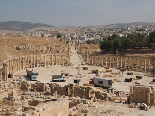
The Forum occupies a strategic position at the southern terminus of the cardo maximus, the principal north–south artery of Gerasa. Rather than existing as an isolated plaza, it functions as an architectural expansion of the colonnaded street. The transition from the linear cardo into the oval space is fluid, achieved through a gradual widening of the urban axis.
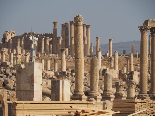
The overall dimensions measure approximately 90 meters along the major axis and 80 meters across the minor axis. The central paved area is enclosed by a continuous colonnade forming a nearly complete oval perimeter. This configuration differs from the orthogonal forums typical of Italy and western provinces, suggesting a deliberate adaptation to site conditions.
The oval shape resolves the geometric challenge of connecting the cardo to adjacent streets and the nearby temple complex. The curvature creates a dynamic spatial experience, guiding visual perspective toward the main urban axis while maintaining enclosure.
Structural Design and Engineering Techniques
The construction required precise geometric planning. The oval is not a true ellipse but a composition of circular arcs joined with calculated transitions. This design demanded advanced surveying techniques and careful layout on site.
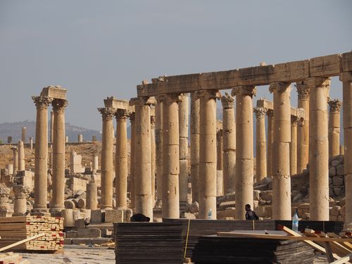
Foundations consist of compacted rubble and stone layers forming a stable annular base. The stylobate supporting the colonnade follows the oval outline with remarkable consistency. The leveling of this continuous platform was essential to ensure structural alignment of the approximately 160 Ionic columns.
Each column is composed of stacked limestone drums secured with metal dowels. The accurate vertical alignment of these elements demonstrates proficiency in lifting and positioning heavy architectural components. The use of cranes and pulley systems would have been indispensable during erection.
The entablature, though only partially preserved, originally unified the colonnade structurally and visually. Its horizontal continuity reinforced lateral stability while creating rhythmic architectural order.
Materials and Construction Methods
Local limestone served as the primary building material. Its abundance in the region and its favorable compressive strength made it suitable for both columns and pavement slabs. Quarrying techniques allowed extraction of large blocks, subsequently shaped with chisels and finishing tools.
The pavement of the central plaza consists of substantial limestone slabs laid over a prepared substructure. A subtle convex profile facilitates rainwater runoff toward peripheral drainage channels. This slight gradient reveals attention to hydrological management.
The Ionic capitals display carved volutes and molded details executed by skilled workshops. While less elaborate than metropolitan examples, the craftsmanship reflects high provincial standards. The repetition of uniform column height and spacing indicates modular planning based on standardized units.
Architectural and Cultural Influences
The Forum adheres to Roman civic design principles while incorporating Hellenistic stylistic elements. The choice of the Ionic order reflects the enduring Greek architectural heritage of the Decapolis region. Gerasa’s cultural background as a Hellenistic foundation influenced its architectural vocabulary.
The oval layout represents a significant variation within Roman forum typology. It may reflect eastern precedents in curved colonnaded plazas or respond pragmatically to terrain and existing street orientation. This hybridization illustrates the interplay between Roman imperial norms and regional experimentation.
Decorative restraint characterizes the composition. Rather than elaborate sculptural programs, the architectural effect relies on proportion, repetition, and spatial coherence. The visual rhythm of the colonnade creates monumentality through multiplicity rather than ornament density.
Spatial Organization and Functional Zoning
The Forum’s interior functioned as a flexible civic arena. The open central space accommodated assemblies, markets, and ceremonial gatherings. The surrounding portico provided sheltered circulation and potential space for statuary or temporary installations.
The connection to the cardo maximus ensured high visibility and accessibility. This axial relationship reinforces the Forum’s role as a transitional node between different urban sectors. The slight elevation of the stylobate relative to the plaza floor delineates pedestrian movement and architectural hierarchy.
The design ensures both enclosure and permeability. While the continuous colonnade defines the boundary, multiple access points maintain integration with adjacent streets.
Dimensional Characteristics and Notable Features
At approximately 90 by 80 meters, the Forum ranks among the largest oval civic spaces in the Roman East. The original 160 columns formed a continuous architectural ring. Surviving columns reach heights of about 5 to 6 meters.
The geometric precision required to maintain consistent intercolumniation along a curved perimeter constitutes a significant technical achievement. Minor deviations in alignment visible today reflect either construction tolerances or later seismic displacement rather than flawed planning.
The Forum’s oval form produces distinctive acoustical and visual properties. Sound projection within the enclosed perimeter would have facilitated public address, while the curvature enhanced perspective depth when viewed from the north.
Later Structural Alterations and Conservation
The earthquake of 749 CE caused widespread collapse of columns and entablature segments. Many columns fell radially outward or inward, fragmenting into drums. Archaeological restoration campaigns in the twentieth century re-erected numerous columns through anastylosis, using original elements wherever possible.
Conservation efforts focus on stabilizing standing columns and mitigating erosion of limestone surfaces. Environmental exposure, temperature fluctuations, and occasional seismic activity pose ongoing challenges.
International Significance and Preservation Context
The Forum’s architectural singularity contributes significantly to the overall value of Jerash as an archaeological ensemble. Its distinctive oval plan distinguishes it from more conventional Roman forums and underscores the adaptability of Roman urban design.
The monument falls under the protection of Jordanian antiquities legislation. Jerash appears on the national tentative list for potential UNESCO World Heritage inscription. Formal recognition would enhance conservation frameworks and international oversight.
Visitor management remains a critical issue. The durability of limestone pavement and column bases requires controlled access to prevent wear. Protective measures aim to balance accessibility with structural integrity.
Architectural Assessment
The Forum of Gerasa exemplifies the translation of Roman civic architecture into a provincial eastern context through technical precision and contextual innovation. Its oval geometry, modular colonnade, and seamless integration with the cardo demonstrate advanced planning and engineering competence. The use of local limestone, standardized column construction, and effective drainage solutions reveal practical adaptation to material and climatic realities.
The monument’s architectural identity rests on spatial coherence and geometric refinement rather than ornamental excess. As a civic space transformed into an archaeological landmark, the Forum preserves a rare example of curvilinear urban design within the Roman world. Its architectural conception illustrates both adherence to imperial models and creative provincial reinterpretation, securing its position as a distinctive achievement of Roman urban architecture in the Near East.