
 Français (France)
  Nederlands (nl-NL)
 Uçhisar and Ortahisar are among the best-known settlements of Cappadocia in central Turkey. They are especially recognized for their striking rock formations and for their historical role in the regional landscape. Located in an area shaped by volcanic geology, these sites provide a representative view of Cappadocian scenery. Uçhisar is often linked to a large rocky prominence overlooking the surrounding area, while Ortahisar retains a strong local character and an active traditional setting. Together, they are important places for understanding the geographic, cultural, and heritage diversity of present-day Cappadocia.
Cappadocia • Uçhisar and Ortahisar
Cappadocia • Uçhisar and Ortahisar
Cappadocia • Uçhisar and Ortahisar
Natural site profile
Uçhisar and Ortahisar
Natural site category: Fairy chimneys
Natural site family: Natural volcanic sculptures
Natural site genre: Terrestrial
Geographic location: Cappadocia • Turkey
This natural site in Cappadocia is inscribed on the UNESCO World Heritage List since 1985 and is part of the serial property "Göreme National Park and the Rock Sites of Cappadocia".See the UNESCO natural sites featured on this site
• Links to •
• List of videos about Cappadocia on this site •
Cappadoce • Göreme, valleys and cave villages Turkey
Uçhisar and Ortahisar: development of a protected landscape in Cappadocia
A natural site shaped by time and human occupation
Uçhisar and Ortahisar rank among the most representative landscapes of Cappadocia in central Anatolia. Both settlements are dominated by imposing rock masses created by ancient volcanic activity and gradually sculpted by erosion. Their distinctiveness lies in the fact that these natural forms were integrated early into human life, serving as shelter, lookout points, storage areas, and the structural core of village settlement. The importance of the site therefore rests not only on geological value, but also on the long relationship between environment and local communities.
The first populations of the region benefited from the special qualities of volcanic tuff, a soft rock that could be excavated with relatively simple tools. Domestic chambers, storerooms, pigeon houses, and defensive refuges were cut into the stone. The heights of Uçhisar and Ortahisar also provided efficient control over surrounding valleys, a major advantage in periods often marked by political instability or military movement.
A landscape reinforced by historical eras
Over the centuries, Cappadocia occupied an important position between several political and cultural spheres of Anatolia and the Near East. During the Byzantine era, the region was marked by Christian communities, monasteries, and rock-cut sanctuaries. Natural reliefs supported functions of retreat, protection, and religious continuity. The landscape thus acquired a spiritual dimension in addition to its defensive and economic uses.
Under Seljuk and later Ottoman rule, Uçhisar and Ortahisar remained active rural centres. Agriculture, livestock raising, local trade, and careful use of environmental resources sustained permanent occupation. The villages evolved without fully abandoning older troglodyte forms of habitation. This capacity for adaptation explains the remarkable continuity of the site.
From rural territory to recognized heritage
The modern turning point came mainly in the twentieth century. With the growth of transport networks, photography, heritage studies, and cultural tourism, Cappadocia attracted increasing international attention. The landscapes of Uçhisar and Ortahisar gradually ceased to be seen only as rural settlements and came to be valued as outstanding witnesses to regional history and Anatolian geology.
Public authorities progressively recognized the multiple value of the site. Economically, tourism offered new employment and diversified local income. Culturally, preservation strengthened the national image of an important historic landscape. Scientifically, the region represented an exceptional example of interaction between volcanism, erosion, and human occupation.
International recognition in the later twentieth century reinforced this process. Cappadocia became established among the major heritage landscapes of the wider Mediterranean and Near Eastern world.
Economic and social transformations
The growth of tourism deeply changed local life. Many former stone houses and excavated dwellings were restored and converted into hotels, restaurants, and commercial spaces. Traditional agriculture remains present, but it now occupies a smaller role than visitor-related services.
This transformation generated income, improved infrastructure, and increased regional visibility. It also changed social balances through rising land values, adaptation of historic buildings, stronger dependence on tourism seasons, and shifts in employment patterns.
Despite these changes, Uçhisar and Ortahisar retain a strong territorial identity. Their dominant rock silhouettes, village streets, and panoramic views over the valleys continue to define the local environment.
Present importance and conservation challenges
Today the site represents one of the most recognizable images of Cappadocia. It combines scenic value, historical memory, and scientific interest. Its reputation extends far beyond the region and contributes to the wider cultural image of Turkey.
Preservation nevertheless remains a constant challenge. The soft rock is vulnerable to natural erosion, water infiltration, climatic variation, and poorly managed interventions. Heavy visitor numbers also require careful management of traffic, parking, restoration works, and the visual integration of new buildings.
The future of Uçhisar and Ortahisar depends on maintaining a balance between economic activity, local quality of life, and respect for an exceptional landscape. The significance of the site lies precisely in this rare alliance between striking natural forms and centuries of human presence that remain clearly visible today.
Uçhisar and Ortahisar: geological forms and emblematic landscapes of Cappadocia
Relief and spatial organization
Uçhisar and Ortahisar occupy two commanding positions within the Cappadocian landscape, a region of central Anatolia renowned for terrain shaped by ancient volcanism. Each site is organized around a massive isolated rock tower visible from long distances. These mineral strongholds rise above the present settlements and structure the surrounding space. Uçhisar forms a broader and higher complex with extensive views across nearby valleys, while Ortahisar is defined by a steeper and more compact central mass.
Around these prominences lie rolling plateaus, cultivated hollows, ravines, and rocky ridges. Spatial organization is closely linked to geology: flatter ground supports roads, agriculture, and modern buildings, while steep sectors preserve the most dramatic natural forms.
Clearly visible volcanic origins
The landscape is based on thick layers of volcanic tuff deposited by major eruptions millions of years ago. Volcanoes of central Anatolia released ash, pumice, and pyroclastic material over wide areas, later consolidating into relatively soft rock. These formations were gradually cut by rainfall, runoff, wind, frost, and temperature contrasts.
This long process of differential erosion explains the presence of Uçhisar and Ortahisar. More resistant sections withstood weathering better than surrounding deposits, which were progressively lowered. The present heights therefore appear as preserved rocky cores standing above terrain extensively remodelled by natural forces.
Rock surfaces often display tones ranging from pale beige to warm ochre, with changing light emphasizing textures, cavities, and stratified layers.
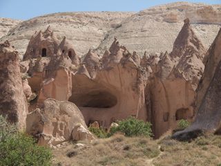
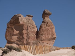
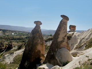
Fairy chimneys and natural sculpture
The surrounding area contains many formations associated with Cappadocia’s famous fairy chimneys. These are columns of tuff left standing by erosion, sometimes protected by a harder capstone. The varied size and silhouette of these pinnacles give the landscape a highly distinctive appearance.
Alongside these vertical forms are rounded cones, hollowed cliffs, narrow gullies, and undulating ridges that can resemble monumental sculpture. Few regions contain such a concentration of naturally carved volcanic shapes within a relatively compact area.
Cavities, internal volumes, and human adaptation
One of the most remarkable features of the site is the ease with which tuff can be excavated while remaining reasonably stable when maintained. The rock masses of Uçhisar and Ortahisar contain numerous artificial chambers, passages, niches, storage rooms, stairways, and lookout openings.
These visible perforations give the cliffs a singular character. They also demonstrate direct adaptation to the natural environment. Rather than importing large quantities of building material, generations of inhabitants used the existing landform as a structural base for settlement.
Living environments and vegetation
The site belongs to a semi-arid environment combining cultivated land, dry open ground, and rocky terrain. Slopes support modest vegetation composed of seasonal grasses, hardy shrubs, and plants adapted to poor soils. Better-watered valleys contain orchards, vineyards, and gardens.
Cliffs and cavities provide shelter for various bird species. Pigeons, small passerines, and birds of prey use natural ledges or former carved niches. This long relationship between rock habitat, farming, and bird life formed part of the traditional local landscape.
Light, climate, and visual perception
The continental climate of Cappadocia strongly influences the appearance of the site. Dry summers offer clear visibility of landforms, while winter snow can cover the rock towers and sharply define their volumes. Spring and autumn introduce changing colours between bare ground, cultivated fields, and seasonal vegetation.
Low-angle light in the morning and late afternoon especially enhances the texture of the tuff. Fissures, cavities, rounded edges, and layered surfaces become more pronounced, helping explain the enduring photographic appeal of the area.
What distinguishes Uçhisar and Ortahisar
The uniqueness of Uçhisar and Ortahisar does not depend on extreme size, but on the rare combination of readable geology, dramatic forms, and long human integration. The two rock towers function as major natural landmarks within an already exceptional region.
They summarize several defining characteristics of Cappadocia: volcanic origins, erosional sculpture, adaptation of habitation to rock, cultivated valleys, and wide open horizons. This synthesis explains their central place among the most recognizable landscapes of Turkey.