
 Français (France)
  Nederlands (nl-NL)
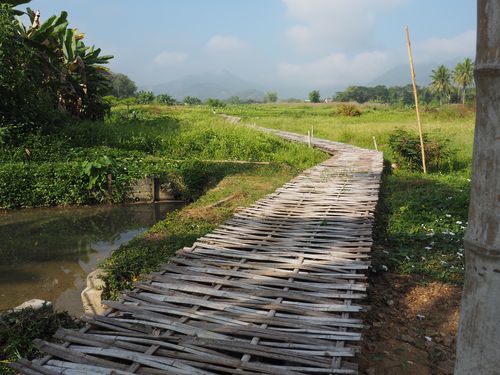
 The surrounding countryside of Luang Prabang in Laos presents a landscape characteristic of the rural regions of northern Laos. Beyond the urban area, river valleys, forested hills, and agricultural fields extend across the territory and shape the daily life of local communities. These rural areas are connected to Luang Prabang through networks of villages, paths, and secondary roads that reflect traditional patterns of settlement and land use. The environment combines cultivated land, tropical vegetation, and landscapes shaped by human activity over generations. Together, these elements form a setting that complements the identity of the historic town and illustrates the close relationship between local populations and their natural surroundings.
Luang Prabang • Surrounding countryside

Luang Prabang • Surrounding countryside

Luang Prabang • Surrounding countryside
Natural site profile
Surrounding countryside
Natural site category: Countryside
Natural site family: Rural landscapes
Natural site genre: Terrestrial
Geographic location: Luang Prabang • Laos
• Links to •
• List of videos about Luang Prabang on this site •
Luang Prabang, Royal Palace • Laos
Luang Prabang, the markets • Laos
Luang Prabang, Wat Sensoukharam temple • Laos
Luang Prabang, Sunset on Mount Phou Si • Laos
Luang Prabang, Wat Xieng Thong temple • Laos
Luang Prabang, paper making workshop • Laos
Laos • Fabric Arts
Luang Prabang, a City in the Countryside • Laos
Luang Prabang, some temples • Laos
The Surrounding Countryside of Luang Prabang: Historical Development, Cultural Landscape, and Contemporary Preservation Challenges
The countryside surrounding Luang Prabang in northern Laos forms an integral part of the broader landscape that has shaped the region’s historical and cultural identity. Located in a valley where the Mekong River meets the Nam Khan River, this rural environment consists of agricultural plains, forested hills, and scattered villages that have evolved over centuries through interaction between natural conditions and human activity. The importance of this landscape lies not only in its ecological value but also in its role as the historical hinterland of Luang Prabang. Political authority, economic activity, and cultural traditions have all contributed to shaping and gradually valuing this environment as a distinctive regional landscape.
Early settlement and the formation of an agricultural landscape
Human settlement in the valleys around Luang Prabang developed in response to the natural advantages provided by the region’s rivers and fertile soils. Floodplains formed by centuries of sediment deposition created favorable conditions for rice cultivation and other agricultural activities.
Communities established villages along riverbanks and valley floors, where water resources and transportation routes were easily accessible. These settlements gradually formed a network of rural communities linked to Luang Prabang through paths and river routes.
Agricultural production in the surrounding countryside played a vital role in sustaining the urban population of Luang Prabang. Rice fields, gardens, and forest resources supplied food and raw materials necessary for everyday life. This interdependence between the city and its rural hinterland became a defining characteristic of the region’s territorial organization.
Political and cultural significance of Luang Prabang
For centuries Luang Prabang served as a political and cultural center in northern Laos. As an important royal capital in the historical Lao kingdoms, the city functioned as an administrative and religious hub. The surrounding countryside supported this urban center by providing agricultural resources and sustaining rural communities that were economically and socially connected to the city.
This relationship between the city and its rural landscape was typical of many Southeast Asian urban centers, where agricultural hinterlands were closely integrated with political and religious institutions. Temples and monastic communities often maintained connections with nearby villages, reinforcing cultural ties across the region.
The countryside therefore played a crucial role in sustaining the broader cultural landscape associated with Luang Prabang.
Colonial transformations and new regional connections
During the late nineteenth century the incorporation of Laos into French Indochina introduced new political and economic influences into the region. Colonial administrators sought to improve transportation and communication networks in order to integrate the Mekong basin more effectively into the colonial economy.
Although Luang Prabang remained relatively remote compared with major colonial centers, colonial exploration and mapping contributed to a better understanding of the surrounding landscapes. Roads and river transport routes gradually strengthened connections between the countryside and regional markets.
At the global level this period coincided with a broader expansion of colonial infrastructure projects, which often transformed rural landscapes while introducing new economic systems. In the case of Luang Prabang, however, many traditional agricultural practices continued to dominate the rural environment.
Recognition of a cultural landscape
During the twentieth century the countryside around Luang Prabang began to be perceived not only as an agricultural territory but also as a cultural landscape shaped by centuries of interaction between human communities and natural environments.
Rice paddies, riverbanks, forests, and village settlements formed a coherent landscape reflecting traditional patterns of land use. Such landscapes are increasingly recognized worldwide as valuable expressions of cultural heritage.
In many regions across Asia and Europe similar rural environments have been preserved because they represent historical relationships between agriculture, settlement, and ecological adaptation. The countryside around Luang Prabang can be understood within this broader global context of cultural landscape conservation.
International recognition and the role of heritage protection
International attention toward Luang Prabang increased significantly in the late twentieth century when the city gained recognition as an important cultural heritage site. This recognition highlighted the need to preserve not only the historic urban area but also the surrounding environment that contributes to the character of the region.
The countryside plays an essential role in maintaining the visual and ecological setting of Luang Prabang. Agricultural terraces, river valleys, and forested hills form the wider landscape that complements the historic town.
This approach reflects a global shift in heritage conservation, where attention increasingly extends beyond individual monuments to include broader cultural and environmental contexts.
Ecological importance of the surrounding countryside
The rural environment around Luang Prabang also possesses ecological value. Forested hills support diverse plant species and provide habitats for birds, reptiles, and small mammals typical of tropical ecosystems.
Rivers and wetlands contribute to aquatic biodiversity and play an important role in maintaining ecological balance. Seasonal flooding enriches soils and supports agricultural productivity while sustaining aquatic habitats.
The combination of agricultural land, forest areas, and waterways creates a diverse ecological mosaic that supports both human livelihoods and natural ecosystems.
Transformations and contemporary pressures
Despite its historical continuity, the countryside surrounding Luang Prabang has experienced gradual transformations. Population growth, infrastructure development, and increased tourism have introduced new economic activities into the region.
Modern roads and transportation networks have improved access to remote villages, but they have also facilitated land-use changes. Some agricultural areas have been converted to new forms of development, and forest resources have been affected by economic pressures.
Such transformations are common in many regions where traditional landscapes encounter rapid economic change.
Challenges for preservation and sustainable development
Today the preservation of the countryside around Luang Prabang faces several challenges. Balancing economic development with environmental protection has become a key concern for regional authorities and local communities.
Tourism, which has become an important source of income, must be managed carefully to prevent damage to fragile rural environments. At the same time, maintaining traditional agricultural practices can help preserve both ecological stability and cultural heritage.
Climate change may also influence the region by altering rainfall patterns and affecting river systems that sustain local agriculture.
A landscape shaped by history and environment
The countryside surrounding Luang Prabang illustrates how natural landscapes and human societies evolve together over long periods of time. Agricultural traditions, political history, and ecological processes have combined to create a landscape that reflects both environmental diversity and cultural continuity.
Today this rural environment remains a vital component of the region’s identity. Its preservation depends on maintaining the balance between development, ecological sustainability, and respect for the cultural landscapes that have shaped the history of Luang Prabang and its surrounding countryside.
Natural Landscape and Ecological Dynamics of the Countryside Surrounding Luang Prabang
The countryside surrounding Luang Prabang in northern Laos presents a diverse natural environment shaped by geological evolution, river dynamics, and tropical biodiversity. Located at the confluence of the Mekong River and the Nam Khan River, the region forms a complex landscape composed of river valleys, forested hills, alluvial plains, and limestone formations. These natural features illustrate long-term geological processes as well as ecological systems that have developed in response to climatic patterns and hydrological cycles. The resulting environment represents a distinctive combination of natural structures and ecological interactions that contribute to the regional identity of northern Laos.
Geological foundations of the landscape
The geological framework of the Luang Prabang region originates from ancient tectonic activity that affected large parts of mainland Southeast Asia. Over millions of years, tectonic movements created uplifted mountain chains and plateaus that gradually shaped the topography of northern Laos.
The hills surrounding Luang Prabang consist mainly of sedimentary and metamorphic rock formations that were later modified by erosion. Water erosion, combined with tropical weathering, carved valleys and slopes that define the present landscape.
In addition to these formations, limestone outcrops are present in parts of the surrounding countryside. These karst landscapes result from the dissolution of carbonate rock by slightly acidic rainwater. Over long periods of time, this process has produced caves, cliffs, and rugged terrain typical of many tropical karst regions.
Such geological formations illustrate natural processes that have been active for millions of years, gradually transforming the terrain into the varied landscape visible today.
River systems and hydrological dynamics
The Mekong River and the Nam Khan River are central elements of the natural environment around Luang Prabang. These rivers influence both the shape of the terrain and the ecological systems that depend on them.
The Mekong, one of Asia’s major rivers, carries enormous volumes of water and sediment from the Tibetan Plateau through mainland Southeast Asia. As the river flows past Luang Prabang, it forms broad curves and deposits layers of sediment along its banks. These deposits create fertile floodplains that support vegetation and agriculture.
The Nam Khan River contributes additional water and sediment from mountainous regions to the east. Where the two rivers meet, the interaction of currents and sedimentation forms a dynamic environment with sandbanks, islands, and shifting river channels.
Seasonal monsoon rains play an important role in this hydrological system. During the wet season, rising river levels spread water across the floodplains, enriching soils and supporting plant growth. In the dry season, lower water levels reveal riverbanks and islands that become temporary ecological habitats.
Biodiversity of tropical forests and river ecosystems
The countryside surrounding Luang Prabang forms part of a broader ecological region characterized by tropical and subtropical forests. These ecosystems support a wide variety of plant and animal species adapted to humid climates and seasonal rainfall.
Forest areas surrounding the valleys contain trees such as teak, bamboo, and other tropical hardwoods. These forests provide habitats for numerous bird species, insects, reptiles, and small mammals.
The rivers and wetlands also support diverse aquatic life. Fish species, amphibians, and aquatic plants are essential components of the river ecosystem. The Mekong basin is recognized as one of the most biologically diverse river systems in the world, with more than one thousand fish species recorded.
Riparian vegetation along riverbanks stabilizes soil and provides shelter for wildlife. These vegetated corridors play an important role in maintaining ecological connectivity between different habitats.
A mosaic of ecosystems shaped by natural processes
One of the most distinctive characteristics of the countryside around Luang Prabang is the coexistence of multiple ecological environments within a relatively small area. Forested hills, agricultural fields, wetlands, and river channels create a mosaic landscape shaped by both natural processes and seasonal climatic cycles.
The region’s tropical monsoon climate contributes to this diversity. Annual rainfall patterns influence vegetation growth, soil formation, and river flow. Heavy rains during the monsoon season accelerate erosion in upland areas while simultaneously depositing sediments in valley floors.
These natural cycles illustrate the interaction between climate, geology, and hydrology. Over long periods of time they have produced landscapes capable of supporting both ecological diversity and human habitation.
Regional environmental influences and global connections
Although the countryside around Luang Prabang is shaped primarily by local environmental conditions, it is also influenced by broader climatic systems that affect Southeast Asia.
Monsoon circulation patterns determine the distribution of rainfall throughout the region. These atmospheric systems originate from large-scale interactions between the Indian Ocean, the Pacific Ocean, and continental landmasses.
Changes in these global climatic patterns can influence river flows, vegetation cycles, and ecological stability. The landscapes around Luang Prabang therefore reflect the interaction between local geological processes and global environmental forces.
Such interactions demonstrate how natural environments are shaped simultaneously by regional and global dynamics.
International recognition of the landscape
Luang Prabang is internationally recognized for its cultural heritage, but the surrounding natural environment also plays an important role in defining the character of the region. The combination of river valleys, forested hills, and agricultural plains creates a landscape that contributes to the broader significance of the area.
International interest in the region has increased awareness of the need to protect both the historic town and its natural surroundings. Conservation initiatives often emphasize the importance of preserving the environmental setting that supports the cultural and ecological integrity of the area.
In many parts of the world, heritage protection has expanded to include entire cultural landscapes rather than isolated monuments. The countryside around Luang Prabang reflects this approach by illustrating the relationship between natural features and human settlement patterns.
Environmental challenges and conservation concerns
Despite its natural richness, the countryside around Luang Prabang faces several environmental pressures. Population growth and economic development can lead to changes in land use, including deforestation and expansion of infrastructure.
Tourism has become an important economic activity in the region, attracting visitors interested in both cultural heritage and natural scenery. While tourism provides economic benefits, it also requires careful management to avoid environmental degradation.
Another potential concern is the modification of river systems through hydropower development in the Mekong basin. Changes in water flow and sediment transport could affect river ecosystems and agricultural practices in downstream regions.
A landscape shaped by geological time and ecological balance
The countryside surrounding Luang Prabang illustrates the complex interplay between geological history, hydrological processes, and tropical biodiversity. Hills formed by tectonic forces, rivers shaped by sediment flows, and ecosystems adapted to monsoon climates all contribute to the distinctive character of the region.
These natural features demonstrate how landscapes evolve through long-term environmental processes while supporting diverse ecological systems. Preserving this balance between natural dynamics and human activity remains essential for maintaining the environmental integrity of the Luang Prabang region.