
 Français (France)
  Nederlands (nl-NL)
 The sunset viewed from Mount Phousy in Luang Prabang is widely regarded as one of the most recognizable panoramas of the city and the Mekong valley. This central hill provides an open vantage point over the Mekong and Nam Khan rivers as well as the historic districts and surrounding landscapes. As daylight fades, changing light gradually alters the appearance of the rivers, hills, and rooftops, creating a distinctive atmosphere that attracts both residents and visitors. This daily moment has become a characteristic way to observe the geographical layout of Luang Prabang and the relationship between the town, its rivers, and the surrounding terrain.

Luang Prabang • Sunset on Mount Phousy

Luang Prabang • Sunset on Mount Phousy
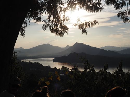
Luang Prabang • Sunset on Mount Phousy
Natural site profile
Sunset on Mount Phousy
Natural site category: Panorama
Natural site family: Mountains and hills
Natural site genre: Terrestrial
Geographic location: Luang Prabang • Laos
• Links to •
• List of videos about Luang Prabang on this site •
Luang Prabang, Royal Palace • Laos
Luang Prabang, the markets • Laos
Luang Prabang, Wat Sensoukharam temple • Laos
Luang Prabang, Sunset on Mount Phou Si • Laos
Luang Prabang, Wat Xieng Thong temple • Laos
Luang Prabang, paper making workshop • Laos
Laos • Fabric Arts
Luang Prabang, a City in the Countryside • Laos
Luang Prabang, some temples • Laos
Mount Phousi and the Cultural Landscape of Sunset in Luang Prabang: Historical Significance, Regional Development, and Contemporary Preservation
Mount Phousi occupies a central position in the landscape of Luang Prabang, Laos, rising prominently from the narrow peninsula formed by the Mekong and Nam Khan rivers. While widely known for the striking sunsets observed from its summit, the importance of the hill extends far beyond its visual appeal. Over centuries, political authority, religious traditions, economic development, and cultural perceptions of landscape have contributed to the preservation and symbolic value of Mount Phousi. The hill and the surrounding environment illustrate how natural landmarks can acquire historical meaning and become integral components of regional identity.
Early cultural and spiritual significance
The earliest motivations for preserving Mount Phousi were largely cultural and spiritual. In Lao traditions, elevated landforms often hold symbolic meaning, representing sacred spaces connected to cosmological beliefs and spiritual protection. Hills and mountains were frequently associated with guardian spirits and were therefore treated with respect by local communities.
Mount Phousi gradually became integrated into the spiritual geography of Luang Prabang. Religious structures were established on its slopes and summit, reinforcing the perception of the hill as a sacred location. These spiritual associations indirectly contributed to the preservation of the site, since sacred landscapes were typically protected from extensive modification or exploitation.
This relationship between spiritual belief and landscape preservation can be observed in many parts of Asia, where mountains and hills have long been regarded as sacred features deserving protection.
The political context of Luang Prabang
Luang Prabang served for centuries as an important political and religious center in northern Laos. As a royal capital of Lao kingdoms, the city played a key role in regional administration and religious life. Mount Phousi, located at the center of the urban peninsula, formed a visible landmark that reinforced the spatial organization of the city.
The hill provided a natural focal point within the urban landscape. Its position allowed it to function as a symbolic axis linking the rivers, the royal and religious districts, and the surrounding countryside. Such integration of natural landforms into urban planning was characteristic of many historical cities in Southeast Asia.
The prominence of Mount Phousi therefore reflected not only geographical conditions but also the political and cultural structure of the city.
Transformations during the colonial era
In the late nineteenth century, the incorporation of Laos into French colonial administration introduced new perspectives on the region’s geography and landscape. European explorers, administrators, and scholars documented the natural features of Luang Prabang and the surrounding valleys.
Mount Phousi attracted particular attention because of its panoramic views over the Mekong and the city. Colonial descriptions of the region often highlighted the aesthetic qualities of the landscape, contributing to the emerging perception of Luang Prabang as a place of scenic beauty.
This period coincided with broader global developments in which natural landscapes were increasingly valued for their aesthetic and scientific significance. Similar trends occurred in other regions of the world, where scenic viewpoints and natural landmarks began to attract travelers and researchers.
The emergence of tourism and cultural appreciation
During the twentieth century, Mount Phousi gradually became a destination for visitors interested in observing the landscape of Luang Prabang. The sunset viewed from the summit became especially well known, as the position of the hill offers unobstructed views of the rivers and surrounding hills.
Tourism contributed to the economic valorization of the site. Local communities and authorities recognized that the hill represented not only a cultural symbol but also a valuable resource for attracting visitors. Paths, stairways, and viewing areas were developed to facilitate access.
The transformation of Mount Phousi into a popular viewing point reflects a broader global phenomenon in which natural landscapes are incorporated into tourism economies while retaining cultural and symbolic importance.
International recognition and landscape preservation
The international recognition of Luang Prabang as a heritage site significantly strengthened efforts to preserve the landscape surrounding the city. Heritage conservation policies increasingly emphasized the importance of maintaining not only historical buildings but also the natural setting that defines the character of the region.
Mount Phousi plays a central role in this landscape because it shapes the visual identity of the city. Its forested slopes and elevated position contribute to the overall harmony between the built environment and the surrounding natural features.
This approach reflects a global shift toward the protection of cultural landscapes, where natural and human elements are preserved together as part of a broader heritage framework.
Comparisons with other global cultural landscapes
The preservation of Mount Phousi can be compared with similar approaches to landscape conservation in other regions of the world. In many historic cities, elevated viewpoints and natural landmarks are recognized as integral components of cultural identity.
Examples include hills overlooking historic towns, sacred mountains associated with religious traditions, and scenic landscapes incorporated into protected heritage zones. In each case, the preservation of natural features enhances the cultural significance of the surrounding environment.
These examples illustrate how landscapes that combine natural beauty and historical meaning often become focal points for heritage conservation and tourism development.
Transformations in the modern era
In recent decades, Mount Phousi has experienced significant changes due to the growing number of visitors who climb the hill to observe the sunset. Tourism has become an important economic driver for Luang Prabang, bringing both opportunities and challenges.
Infrastructure improvements such as stairways, viewing platforms, and lighting have made the site more accessible. These developments have allowed a larger number of visitors to experience the panorama while supporting local businesses and services.
However, increased visitor numbers can also lead to environmental pressures, including erosion of pathways and disturbances to vegetation.
Contemporary challenges and future preservation
The preservation of Mount Phousi requires careful management to balance tourism with environmental protection. Maintaining the natural vegetation on the hill is essential for stabilizing soils and preserving the ecological character of the site.
Urban expansion in Luang Prabang also presents challenges, as new construction can alter the visual relationship between the hill and the surrounding landscape. Protecting the skyline and the natural silhouette of Mount Phousi is therefore an important consideration for local planning authorities.
Another potential challenge involves broader environmental changes affecting the Mekong basin. Alterations in river flow patterns, climate variability, and regional development projects may influence the ecological balance of the area.
A symbolic landscape shaped by history and nature
Mount Phousi represents a unique example of how a natural landform can acquire historical, cultural, and economic significance over time. The famous sunset viewed from its summit is not only a scenic experience but also a reflection of the complex interactions between geography, culture, and history.
From sacred hill to colonial viewpoint and modern tourist destination, Mount Phousi illustrates how landscapes evolve in response to changing social values and environmental conditions. Preserving this balance between natural integrity and human appreciation remains essential for safeguarding the long-term significance of this emblematic site in Luang Prabang.
Natural Landscape and Environmental Dynamics of Mount Phousi at Sunset in Luang Prabang
Mount Phousi occupies a central position in the geographical and environmental structure of Luang Prabang in northern Laos. Rising approximately one hundred meters above the surrounding urban area, the hill stands on the narrow peninsula formed by the confluence of the Mekong River and the Nam Khan River. Although often associated with the well-known sunset panorama admired by visitors, the natural importance of Mount Phousi lies in its geological formation, its role within the river valley landscape, and its ecological relationship with the surrounding environment. The site illustrates how geological processes, hydrological dynamics, and tropical ecosystems combine to shape a distinctive natural setting that has influenced both the development and the perception of Luang Prabang.
Geological formation and topographic prominence
Mount Phousi represents a relatively isolated geological formation within the broader landscape of northern Laos. The hill is composed mainly of sedimentary rock formations that have been shaped over long geological periods by tectonic movements and erosion processes. These formations are part of the wider geological structures that define much of mainland Southeast Asia, where ancient tectonic activity produced a landscape of valleys, plateaus, and low mountain ranges.
Erosion caused by rainfall and river activity gradually sculpted the hill and the surrounding terrain. Over thousands of years, weathering processes weakened the rock surfaces, allowing vegetation to establish itself on the slopes. The result is a rounded hill that contrasts with the flatter alluvial plains surrounding it.
The topographic prominence of Mount Phousi is particularly significant because it rises directly from the urban peninsula between two major rivers. From its summit, observers can clearly see the natural structure of the landscape: the winding course of the Mekong, the narrower channel of the Nam Khan, and the mosaic of hills and valleys extending into the distance.
River systems and the shaping of the landscape
The geographical importance of Mount Phousi cannot be understood without considering the influence of the Mekong and Nam Khan rivers. These waterways have played a decisive role in shaping the terrain surrounding Luang Prabang.
The Mekong is one of the longest rivers in Asia and transports enormous volumes of sediment through its basin. As it flows past Luang Prabang, the river deposits layers of silt and sand that create fertile alluvial plains. These plains form the base of the peninsula on which the city developed.
The Nam Khan, which flows from mountainous regions to the east, contributes additional water and sediment to the system. The confluence of the two rivers generates complex hydrological dynamics, including seasonal flooding, shifting sandbanks, and constantly changing river channels.
Mount Phousi rises at the center of this river system, providing a natural vantage point from which these hydrological processes can be observed. The sunset viewed from the summit often highlights the reflective surfaces of the rivers, emphasizing the relationship between topography, water, and atmospheric conditions.
Ecological environment and tropical biodiversity
Although Mount Phousi is located within an urban environment, it still supports elements of tropical vegetation typical of northern Laos. The slopes of the hill contain a mixture of trees, shrubs, and smaller plant species adapted to seasonal rainfall and warm temperatures.
This vegetation provides habitat for birds, insects, and small animals that inhabit the region’s forest ecosystems. Even in a relatively small area such as Mount Phousi, biodiversity can persist due to the presence of vegetation corridors that connect the hill with nearby forested landscapes.
The surrounding valleys and riverbanks support additional ecological diversity. Riparian vegetation stabilizes soil along the river edges and contributes to the ecological balance of the river system. Fish, amphibians, and bird species depend on these habitats, which are closely linked to seasonal water cycles.
The Mekong basin is known as one of the most biologically diverse river systems on Earth, with more than one thousand recorded fish species and a wide range of aquatic habitats.
Atmospheric conditions and the visual phenomenon of sunset
The famous sunset observed from Mount Phousi is partly the result of atmospheric conditions that are characteristic of tropical river valleys. Dust particles, humidity, and water vapor in the air interact with sunlight as the sun approaches the horizon.
These conditions scatter shorter wavelengths of light and enhance warmer colors such as red, orange, and gold. The reflective surfaces of the Mekong and Nam Khan amplify these colors, creating dramatic contrasts between the rivers, hills, and sky.
Because Mount Phousi is located above the surrounding terrain, it provides an unobstructed view of these atmospheric effects. The visual transformation of the landscape at sunset is therefore not only a scenic experience but also a manifestation of natural optical and climatic processes.
Interaction between local environmental factors and global systems
The environmental conditions surrounding Mount Phousi are influenced by broader climatic systems that affect Southeast Asia. The region experiences a tropical monsoon climate characterized by alternating wet and dry seasons.
Monsoon winds bring heavy rainfall during part of the year, feeding the rivers and supporting the growth of vegetation. During the dry season, clearer skies and lower humidity create favorable conditions for the dramatic sunsets that attract visitors to the hill.
These climatic patterns are linked to large-scale atmospheric circulation systems involving the Indian Ocean and the Pacific Ocean. As a result, the landscape around Luang Prabang reflects both local environmental processes and global climatic influences.
International recognition and landscape preservation
The broader landscape of Luang Prabang has received international attention due to its cultural and environmental significance. The hill of Mount Phousi forms a central visual element within this landscape and contributes to the overall identity of the region.
The recognition of the city as an important heritage site has also encouraged efforts to preserve the surrounding natural environment. Maintaining the visual integrity of the hill and the river valleys is considered essential for protecting the character of the landscape.
This approach reflects a broader global trend in heritage conservation, where natural settings are increasingly recognized as integral components of cultural landscapes.
Contemporary environmental challenges
Despite its relatively small size, Mount Phousi faces several environmental pressures. Increasing numbers of visitors climb the hill to observe the sunset, which can lead to erosion of pathways and disturbances to vegetation.
Urban expansion in Luang Prabang also affects the ecological balance of the surrounding landscape. Changes in land use, infrastructure development, and increased tourism activity can place stress on local ecosystems.
Another long-term concern relates to the hydrological dynamics of the Mekong River. Large-scale water management projects elsewhere in the river basin may influence sediment flows and water levels, potentially affecting the ecological conditions of the region.
A natural landmark shaped by landscape processes
Mount Phousi illustrates how geological formation, river dynamics, ecological diversity, and atmospheric phenomena can combine to create a distinctive natural landmark. The hill stands not only as a scenic viewpoint but also as a natural indicator of the environmental systems that define the Luang Prabang region.
From its summit, the landscape reveals the intricate relationship between rivers, valleys, and tropical vegetation. The famous sunset seen from Mount Phousi thus reflects more than a visual spectacle: it represents the convergence of natural processes that have shaped the geography and ecological character of northern Laos.