

 Français (France)
  Nederlands (nl-NL)
 Of Hindu tradition, (with additional Jain influence), the Shilahara dynasty ruled for approximately 500 years, ± between 0765 and 1265 over all or part of South India and West India, during the Classical Period and the Medieval Period.
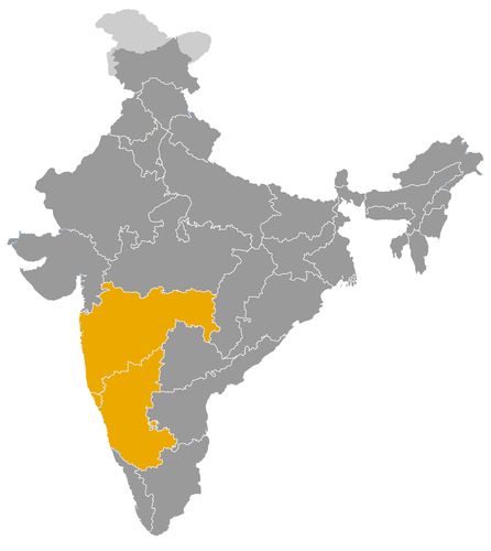
This map illustrates the maximum territory that the Shilahara Dynasty had reached at its height, covering the current regions of Goa, Karnataka and Maharashtra in India. Its main purpose is to provide a visual aid to understand the geographical extent of this dynasty. However, it's important to note that the contemporary borders of these regions may not necessarily coincide with the historical territories.
The Place and Role of the Shilahara Dynasty in Indian History
A Regional Dynasty of Western India
The Shilaharas, also known as Silaharas, were an important regional dynasty of medieval western India. Their power developed between the eighth and thirteenth centuries, mainly along the Konkan coast and in parts of southern Maharashtra. They did not form one continuous imperial state, but several related branches ruling different territories. The main branches were those of North Konkan, South Konkan and Kolhapur.
Their historical role must therefore be understood within the political geography of the western Deccan. The Shilaharas governed regions that connected the Arabian Sea with the inland plateau. This position gave them strategic importance in trade, military movement, taxation and communication between coastal and interior zones. Although they were often subordinate to greater powers, they exercised real local authority and contributed to the political, cultural and economic development of western India.
Political Authority under Larger Imperial Powers
The Shilaharas were frequently feudatories of stronger dynasties, especially the Rashtrakutas, the Western Chalukyas and later the Yadavas of Devagiri. This subordinate status did not make them insignificant. In the medieval Deccan, regional rulers often governed as local dynasts while acknowledging the suzerainty of a larger imperial house.
The early Shilahara branches probably rose under Rashtrakuta patronage. Their control of the Konkan was useful for the Rashtrakutas, whose main centres were located inland. Through the Shilaharas, the imperial power could extend its influence over the western coast, its ports and the routes crossing the Western Ghats.
After the decline of the Rashtrakutas, the Shilaharas adjusted to changing political conditions. Some branches came under the influence of the Western Chalukyas, while others were gradually absorbed by the Yadavas of Devagiri. Their ability to survive through these transitions shows the flexibility of local power in medieval India. They were not merely passive dependants, but regional actors who negotiated, adapted and preserved authority as long as political circumstances allowed.
Control of Coastal and Inland Strategic Zones
The geographical position of the Shilaharas was central to their importance. The North Konkan branch, based around Thane, controlled a coastal region close to the area of present-day Mumbai. This zone included ports, estuaries, maritime routes and access points toward the Deccan plateau. Its control was valuable for trade and for military communication.
The South Konkan branch occupied another portion of the western coast, linked to areas such as Chandrapuri, Chaul and the wider coastal world near Goa. This branch connected local coastal society with broader circuits of exchange along the Arabian Sea.
The Kolhapur branch differed from the coastal branches because it was located farther inland, in southern Maharashtra. Its territory included important centres such as Kolhapur, Karad, Miraj and Panhala. This region controlled agricultural lands, fortified places and routes between Maharashtra, Karnataka and the western coast. Through these branches, the Shilaharas helped shape the political map of western India over several centuries.
Economic Role in Trade, Revenue and Regional Exchange
The Shilahara economy was strongly linked to geography. The Konkan coast was part of maritime networks that connected western India with the Arabian Sea trade. Ports and coastal markets enabled the movement of goods such as salt, coconuts, agricultural produce, textiles, metals and other commodities. Local rulers benefited from customs, market taxes, land revenue and control of transit routes.
The Shilaharas also controlled mountain passes leading through the Western Ghats. These routes connected coastal settlements with inland markets and political centres. By securing such passages, the dynasty helped maintain commercial exchange between the sea and the Deccan.
In the Kolhapur region, economic power depended more directly on agriculture, inland trade and the management of fortified centres. The combination of coastal revenues and inland resources gave the different Shilahara branches an economic importance greater than the size of their territories might suggest.
Cultural Patronage and Religious Foundations
The cultural impact of the Shilaharas is visible in their religious patronage and in the architectural development of western India. Their inscriptions record donations to temples, Brahmins and religious institutions. Like many medieval Indian rulers, they used religious patronage to affirm legitimacy, display generosity and strengthen links with local elites.
The Shilaharas supported Hindu religious traditions, especially forms of Shaivism and Vaishnavism, while also interacting with the broader religious diversity of the region. Some evidence also points to patronage connected with Jain communities in certain areas. Their rule therefore formed part of the wider religious landscape of the medieval Deccan, where dynastic authority, temple culture and land grants were closely connected.
In architectural terms, the Shilahara period contributed to the construction and maintenance of temples, shrines, reservoirs and local sacred sites. Their legacy is not defined by one monumental capital, but by a dispersed pattern of religious and regional patronage. This type of contribution was typical of many medieval Indian dynasties whose influence was deeply local but historically significant.
A Dynasty Illustrating the Importance of Regional Power
The Shilaharas occupy an important place in Indian history because they show how regional dynasties operated within larger imperial systems. They were not creators of a subcontinental empire, but they were essential intermediaries between great powers and local societies. They administered strategic regions, protected routes, supported trade, patronized religious institutions and maintained political continuity in the western Deccan.
Their eventual absorption by the Yadavas of Devagiri did not erase their historical role. The territories they governed remained important in later periods, especially the Konkan coast, Thane, Kolhapur and southern Maharashtra. The Shilaharas therefore represent a significant example of medieval Indian regional statecraft, where political influence was measured not only by imperial conquest, but also by control of strategic landscapes, economic corridors and cultural institutions.
The Geographical Expansion of the Shilahara Dynasty in India
A Regional Power Divided among Three Branches
The geographical expansion of the Shilahara dynasty must be understood as the development of several regional branches rather than the growth of a single centralized empire. Between the eighth and thirteenth centuries, the Shilaharas controlled important territories in western India, especially along the Konkan coast and in parts of southern Maharashtra. Their lands were located between the Arabian Sea, the Western Ghats and the Deccan plateau, a zone of considerable strategic and economic value.
Historians usually distinguish three main branches: the Shilaharas of North Konkan, the Shilaharas of South Konkan and the Shilaharas of Kolhapur. These branches were related but not always politically unified. Each ruled its own territory, often as feudatories of larger powers such as the Rashtrakutas, the Western Chalukyas and later the Yadavas of Devagiri. Their expansion was therefore regional, coastal and inland, shaped by geography, trade routes and changing patterns of suzerainty.
North Konkan and the Strategic Region around Thane
The North Konkan branch was one of the most important and long-lasting Shilahara lines. Its power was centred on the region of Thane, near the area of present-day Mumbai. This territory included coastal settlements, estuaries, ports and routes leading inland through the Western Ghats. Control of this region gave the Shilaharas influence over maritime trade and over communications between the coast and the Deccan plateau.
North Konkan was valuable because it stood at the meeting point of sea routes and inland political networks. The Shilaharas who ruled from this area acted as intermediaries between coastal merchants, local communities and larger imperial powers. Their authority helped extend the influence of the Rashtrakutas and later other Deccan dynasties into a region that was difficult to administer directly from inland capitals.
Over time, the North Konkan branch developed considerable local autonomy. Rulers such as Kapardin, Aparajita, Ananta Deva and Someshvara maintained Shilahara authority in the region for several centuries. However, their independence was never absolute. Their territory remained exposed to the ambitions of stronger powers, especially the Yadavas of Devagiri, who eventually absorbed the region in the thirteenth century.
South Konkan and the Coastal World of Western India
The South Konkan branch controlled another portion of the western coastline. Its territory was connected with areas such as Chandrapuri, Chaul, Goa and other coastal centres. This branch occupied a zone where maritime exchange, local ports, agricultural hinterlands and mountain routes interacted closely.
The South Konkan was economically significant because it was open to trade along the Arabian Sea. Coastal products, salt, coconuts, agricultural goods and commercial traffic moved through this region. The Shilahara rulers could benefit from market taxes, customs duties and control over routes linking the coast with the interior.
Politically, the South Konkan branch had to manage relations with several neighbouring powers. Its rulers operated between local coastal chiefs, the Rashtrakutas, the Western Chalukyas and other regional dynasties. The branch appears to have declined earlier than the North Konkan line, as its territories gradually came under the influence of stronger Deccan powers. This shows how vulnerable coastal domains could be when larger inland dynasties sought access to ports and maritime revenue.
Kolhapur and the Inland Expansion of Shilahara Authority
The Kolhapur branch represented the inland dimension of Shilahara expansion. Its territory included areas around Kolhapur, Karad, Miraj and Panhala in southern Maharashtra. Unlike the Konkan branches, this line was based less on maritime control and more on agricultural lands, fortified centres and routes linking Maharashtra, Karnataka and the western coast.
The position of Kolhapur gave this branch strategic importance. It lay near major routes between the Deccan plateau and the coastal world, and it also bordered territories influenced by the Western Chalukyas, the Kadambas and later the Yadavas of Devagiri. The Shilaharas of Kolhapur therefore played an important role in the political balance of southern Maharashtra.
Under rulers such as Gonka, Gandaraditya, Vijayaditya and Bhoja II, the Kolhapur branch became one of the most prominent Shilahara lines. It controlled inland resources and maintained a strong local identity. However, it too was eventually overcome by the Yadavas of Devagiri, whose expansion brought an end to Shilahara autonomy in the region.
Relations with the Rashtrakutas and Western Chalukyas
The geographical position of the Shilaharas strongly influenced their relations with neighbouring dynasties. Their earliest rise was closely connected to the Rashtrakutas, who used local feudatory families to control strategic regions. By placing or supporting Shilahara rulers in the Konkan, the Rashtrakutas could extend their authority from the Deccan plateau to the Arabian Sea.
After the decline of the Rashtrakutas, the Western Chalukyas became a major force in the Deccan. The Shilaharas adapted to this new political order. Some branches acknowledged Chalukya overlordship while retaining local power. This pattern of subordination and autonomy was typical of medieval Indian politics, where regional dynasties often survived by accepting the suzerainty of stronger neighbours.
Conflict and Absorption under the Yadavas of Devagiri
The Yadavas of Devagiri became the decisive rivals of the later Shilaharas. As the Yadavas expanded across Maharashtra and toward the western coast, the Shilahara territories became increasingly vulnerable. The Konkan and Kolhapur regions were too strategic to remain outside Yadava control.
The defeat of Bhoja II of Kolhapur and the later absorption of North Konkan under Yadava authority marked the end of effective Shilahara rule. This process was not merely a dynastic replacement. It reflected the broader consolidation of western India under stronger regional powers in the thirteenth century.
A Regional Expansion with Strategic Consequences
The geographical expansion of the Shilaharas was limited in scale but highly significant. They controlled key zones of the Konkan coast, Thane, Kolhapur and southern Maharashtra, linking ports, mountain passes, agricultural lands and inland political centres. Their territories shaped relations between the Arabian Sea and the Deccan plateau, between local elites and imperial powers, and between coastal commerce and inland statecraft.
Their legacy lies in the regional structure they helped create. Although eventually absorbed by the Yadavas, the Shilaharas contributed to the political, economic and cultural formation of medieval western India. Their history shows that control of strategic corridors, ports and regional centres could give a dynasty lasting importance even without imperial expansion.
The Shilaharas, or Silaharas, did not form a single continuous dynasty, but three related branches established in North Konkan, South Konkan and the Kolhapur region. Their rulers were often feudatories of the Rashtrakutas, the Western Chalukyas and later the Yadavas of Devagiri, even when they exercised effective local authority. The dates are indicative and may vary according to inscriptions and historical reconstructions.
- Sanaphulla (c. 765–795) • Founder of the South Konkan branch, he received authority in the context of Rashtrakuta domination.
- Dhammayira (c. 795–820) • Ruler of South Konkan, he is associated with the consolidation of the coastal domain and the fortification of Vallipattana.
- Kapardin I (c. 800–825) • First known ruler of the North Konkan branch, he governed the Thane region under Rashtrakuta suzerainty.
- Aiyaparaja (c. 820–845) • Ruler of South Konkan, he is mentioned for his successes at Chandrapuri, in the Goa area.
- Pullashakti (c. 825–850) • Ruler of North Konkan, he continued the organization of the coastal domain around Thane and its dependencies.
- Avasara I (c. 845–870) • Ruler of South Konkan, his reign appears to have been a period of political continuity.
- Kapardin II (c. 850–880) • Ruler of North Konkan, he kept the Thane branch within the sphere of the Deccan powers.
- Adityavarman (c. 870–895) • Ruler of South Konkan, he extended Shilahara influence toward Chandrapuri and Chaul.
- Vappuvanna (c. 880–910) • Ruler of North Konkan, he belonged to the consolidation phase of the Thane branch.
- Avasara II (c. 895–920) • Ruler of South Konkan, he continued the regional policy of influence pursued by his predecessors.
- Jhanjha (c. 910–930) • Ruler of North Konkan, he is associated with dynastic continuity before the rise of Goggiraja.
- Indraraja (c. 920–945) • Ruler of South Konkan, he preceded a period of conflict with the local powers of Goa.
- Goggiraja (c. 930–945) • Ruler of North Konkan, he governed during a transition between Rashtrakuta authority and regional rivalries.
- Jatiga I (c. 940–960) • First ruler of the Kolhapur branch, he established Shilahara authority in southern Maharashtra.
- Vajjada I (c. 945–965) • Ruler of North Konkan, he maintained the Thane branch in an unstable political context.
- Bhima (c. 945–970) • Ruler of South Konkan, he is presented as an opponent of the powers of Chandrapuri.
- Naivarman (c. 960–980) • Ruler of the Kolhapur branch, he continued the dynastic establishment in southern Maharashtra.
- Chhadvaideva (c. 965–975) • Ruler of North Konkan, he ensured a short transition within the Thane line.
- Aparajita (c. 975–1010) • Ruler of North Konkan, he was one of the important leaders of the Thane branch.
- Avasara III (c. 970–995) • Ruler of South Konkan, he governed during a period of regional political tension.
- Chandra (c. 980–1000) • Ruler of the Kolhapur branch, he preceded the more visible assertion of Jatiga II.
- Rattaraja (c. 995–1020) • Last notable ruler of South Konkan, he had to face the passage of the region into the Chalukya sphere.
- Jatiga II (c. 1000–1020) • Ruler of Kolhapur, he strengthened the branch around Karad and Panhala.
- Vajjada II (c. 1010–1015) • Ruler of North Konkan, he governed briefly after Aparajita.
- Arikesarin (c. 1015–1022) • Ruler of North Konkan, he ensured the continuity of the Thane branch at the beginning of the 11th century.
- Gonka (c. 1020–1050) • Ruler of Kolhapur, he is associated with expansion toward Karad, Miraj and Konkan.
- Chhittaraja (c. 1022–1035) • Ruler of North Konkan, he is traditionally linked to religious foundations in the Mumbai and Thane region.
- Nagarjuna (c. 1035–1045) • Ruler of North Konkan, he maintained Shilahara authority in the northern western coast.
- Mummuniraja (c. 1045–1070) • Ruler of North Konkan, he governed before the long phase of Ananta Deva I.
- Guhala I (mid-11th century) • Ruler of the Kolhapur branch, he is known from dynastic tradition but his dating remains uncertain.
- Kirtiraja (mid-11th century) • Ruler of Kolhapur, he belongs to a poorly documented phase of the line.
- Chandraditya (mid-11th century) • Ruler of Kolhapur, his reign is generally placed before Marsimha in the dynastic succession.
- Marsimha (c. 1050–1075) • Ruler of Kolhapur, he consolidated the southern branch after the period of Gonka.
- Ananta Deva I (c. 1070–1127) • Ruler of North Konkan, he reigned for a long period and maintained the local autonomy of the Thane branch.
- Guhala II (c. 1075–1085) • Ruler of Kolhapur, he preceded the rise of Bhoja I and Gandaraditya.
- Bhoja I (c. 1085–1100) • Ruler of Kolhapur, he reigned under pressure from neighbouring Chalukya power.
- Ballala (c. 1100–1108) • Ruler of Kolhapur, he ensured a short transition before Gandaraditya.
- Gonka II (early 12th century) • Ruler of Kolhapur, his reign is poorly dated but belongs to the period before or around Gandaraditya.
- Gandaraditya (c. 1108–1138) • Ruler of Kolhapur, he is associated with temple patronage and the religious development of the region.
- Aparaditya I (c. 1127–1148) • Ruler of North Konkan, he succeeded Ananta Deva I in the Thane branch.
- Vijayaditya I (c. 1138–1175) • Ruler of Kolhapur, he continued Shilahara authority in southern Maharashtra.
- Haripaladeva (c. 1148–1155) • Ruler of North Konkan, he governed briefly in the mid-12th century.
- Mallikarjuna (c. 1155–1170) • Ruler of North Konkan, he maintained the continuity of the Thane branch.
- Aparaditya II (c. 1170–1197) • Ruler of North Konkan, he reigned during a period of growing competition among the Deccan powers.
- Bhoja II (c. 1175–1212) • Last great ruler of Kolhapur, he was eventually displaced by the Yadavas of Devagiri.
- Ananta Deva II (c. 1198–1200) • Ruler of North Konkan, he governed briefly at the end of the 12th century.
- Keshideva II (c. 1200–1245) • Ruler of North Konkan, he maintained the Thane branch until the mid-13th century.
- Ananta Deva III (c. 1245–1255) • Ruler of North Konkan, he reigned during a period of declining Shilahara authority.
- Someshvara (c. 1255–1265) • Last known ruler of North Konkan, he was defeated when the region passed under Yadava domination.
 Links to the main sections of the site