

 Français (France)
  Nederlands (nl-NL)
 Of Hindu tradition, (with additional Jain influence), the Chahamana of Chandravati dynasty ruled for approximately 638 years, ± between 1311 and 1949 over all or part of North India, during the Medieval Period and the Colonial Period.
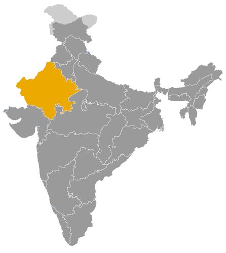
This map illustrates the maximum territory that the Chahamana of Chandravati Dynasty had reached at its height, covering the current regions of Rajasthan in India. Its main purpose is to provide a visual aid to understand the geographical extent of this dynasty. However, it's important to note that the contemporary borders of these regions may not necessarily coincide with the historical territories.
The Chahamanas of Chandravati and Their Role in the History of Western India
A regional Chauhan lineage in the Abu and Sirohi region
The Chahamanas of Chandravati, generally associated with the Deora branch of the Chauhans, occupied a regional but significant place in the history of medieval western India. Their power developed around Chandravati, an ancient settlement near present day Abu Road, at the foot of Mount Abu in southern Rajasthan. This location placed them between the Rajput territories of Rajasthan and the politically and economically dynamic region of Gujarat.
The dynasty did not build a large empire, and its historical importance should not be measured by territorial scale alone. Its role lay in controlling a strategic zone of passage, protecting a local political base, and contributing to the continuity of Chauhan power after the decline of earlier Chahamana centers. In this sense, the Chahamanas of Chandravati illustrate how secondary Rajput lineages could survive, adapt and create durable regional states in a changing political environment.
Their history is also closely linked to the later development of Sirohi. The Deora Chauhans gradually shifted their political center from Chandravati toward Shivpuri and then Sirohi, where their authority became more firmly established. Chandravati therefore represents an early and formative phase in the history of this regional power.
Political authority shaped by a frontier position
The political role of the Chahamanas of Chandravati was determined by geography. Their territory stood at a point of contact between several spheres of influence: Mewar to the north and east, Gujarat to the south and southwest, and the wider Rajput world of Rajasthan to the west and northwest. This position made the dynasty both vulnerable and useful.
Chandravati was not merely a dynastic seat. It was a political and strategic node in a region crossed by armies, merchants, pilgrims and local chiefs. The rulers had to maintain authority over villages, routes, fortified sites and subordinate groups. Their power was therefore based on a combination of military control, local alliances and recognition by surrounding elites.
Like many Rajput states of the medieval period, the Chahamanas of Chandravati did not always exercise power through fixed borders in the modern sense. Their authority was strongest in the immediate zone around Chandravati and Mount Abu, while more distant areas may have depended on looser forms of allegiance. This flexible structure allowed them to survive in a region exposed to larger powers.
Relations with Gujarat, Mewar and the Delhi Sultanate
The dynasty’s relations with neighboring powers were deeply influenced by its location. Gujarat, ruled at different periods by powerful dynasties such as the Chaulukyas and later the Vaghelas, was one of the most prosperous regions of medieval India. Its wealth came from agriculture, urban centers, merchant networks and maritime trade. The Chahamanas of Chandravati did not control the coastal economy, but they were close enough to the land routes leading into Gujarat to be affected by its prosperity and political struggles.
To the north and east, Mewar represented another important neighbor. The Guhilas and later Sisodias of Mewar were expanding and consolidating their own authority in southern Rajasthan. Relations between Chandravati and Mewar likely included competition over frontier zones, local alliances, and the need to balance military security with diplomacy.
The expansion of the Delhi Sultanate added another layer of pressure. Campaigns into Rajasthan and Gujarat weakened older regional powers and forced smaller Rajput lineages to adapt. The Chahamanas of Chandravati survived not by confronting every larger state directly, but by anchoring themselves in defensible terrain and shifting their political center when necessary. This pragmatism was central to their endurance.
Cultural significance in the sacred landscape of Mount Abu
The cultural importance of the Chahamanas of Chandravati must be understood in relation to Mount Abu and its surrounding sacred landscape. The region was associated with Hindu and Jain religious traditions and contained important temples, pilgrimage routes and monastic networks. In such an environment, political legitimacy depended not only on military strength, but also on the ability to protect and support religious institutions.
The rulers of Chandravati participated in a broader Rajput culture of patronage. Support for temples, religious specialists, inscriptions and local sacred sites helped strengthen dynastic authority. Even when direct evidence for specific acts of patronage is limited or difficult to separate from that of neighboring powers, the dynasty belonged to a political culture in which religious protection was essential to kingship.
Their cultural role was therefore not that of a vast imperial court producing a uniform artistic style. It was more regional and embedded. They contributed to the continuity of a sacred and political landscape where Rajput identity, religious authority and local prestige were closely connected.
Economic foundations based on routes, agriculture and local control
The economic base of the Chahamanas of Chandravati came from the resources typical of a medieval regional state. These included agricultural revenues, village taxes, market dues, pastoral resources and control over routes between Rajasthan and Gujarat. The position of Chandravati near important passages gave the dynasty access to traffic moving between inland Rajasthan and the commercial networks of western India.
This economic role was significant because Gujarat was one of the richest regions of the subcontinent. Merchants, pilgrims and artisans moved through the broader zone, and local rulers could benefit from tolls, protection arrangements and market regulation. Control over routes did not require possession of a large empire. A small but strategically placed state could derive influence and income from movement across its territory.
The stability of this economy depended on security. When the rulers could protect roads and villages, agriculture and exchange were strengthened. When conflict intensified, the same routes became vulnerable to disruption, raids and military pressure.
A modest dynasty with lasting regional importance
The Chahamanas of Chandravati were not among the dominant imperial powers of India, but they remain important for understanding the political structure of medieval Rajasthan. Their history shows how Rajput lineages created authority through forts, routes, sacred centers and flexible alliances.
Their role was political, cultural and economic. Politically, they preserved a Chauhan presence in the Abu and Sirohi region. Culturally, they participated in the religious and dynastic landscape of Mount Abu. Economically, they controlled a corridor between Rajasthan and Gujarat. Their gradual movement toward Sirohi demonstrates the adaptability of regional Rajput power and the importance of geography in shaping the history of western India.
The Geographic Extent of the Chahamanas of Chandravati in Medieval Western India
A territorial base at the foot of Mount Abu
The Chahamanas of Chandravati, commonly associated with the Deora branch of the Chauhans, ruled a regional territory in western India during the medieval period. Their first important center was Chandravati, an old settlement near present day Abu Road, at the foot of Mount Abu in southern Rajasthan. This location gave the dynasty a strategic position between the hill regions of Rajasthan and the plains and trade routes leading into Gujarat.
Their domain was not a large empire with clearly fixed borders. It was a regional polity built around fortified sites, dependent villages, roads, religious centers and local alliances. In medieval India, territorial control often depended less on continuous boundaries than on the ability to hold key places, collect revenue, command armed followers and secure the loyalty of local chiefs. The Chahamanas of Chandravati should therefore be understood as rulers of a compact but strategically placed zone rather than as sovereigns of an extensive kingdom.
Chandravati as the first political center of Deora power
The rise of the Chandravati branch followed the weakening of earlier Chahamana centers in northern and western India. The Deora Chauhans established themselves around Chandravati and the Mount Abu region, where they could rely on defensible terrain and access to important routes. Rao Lumba is traditionally regarded as a key founder of Deora authority in this area during the early fourteenth century.
The initial territory controlled by the dynasty likely included Chandravati itself, nearby villages, the lower slopes and approaches to Mount Abu, and road connections between southern Rajasthan and northern Gujarat. This core area provided agricultural income, access to local markets, and control over movements through a region used by merchants, pilgrims and military forces.
Chandravati’s significance also came from its older urban and religious background. It was not merely a fort or a village stronghold, but part of a wider cultural and economic landscape linked to Mount Abu. By establishing authority there, the Deora Chauhans inserted themselves into an already important regional network.
Expansion toward Abu, Shivpuri and Sirohi
The geographic development of the Chahamanas of Chandravati was marked by a gradual shift from Chandravati toward other centers, especially Shivpuri and later Sirohi. This movement reflected the political needs of the dynasty. Chandravati was valuable because of its location near trade and pilgrimage routes, but the more rugged areas around Sirohi offered stronger defensive advantages.
The dynasty’s territory expanded or reoriented itself across parts of south western Rajasthan. The region associated with Abu, Chandravati and Sirohi formed the main zone of Deora authority. This area included hill country, passes, agrarian settlements and routes linking Rajasthan to Gujarat. The rulers did not necessarily control all these spaces with equal intensity. Their authority was strongest near their political centers and weaker in peripheral zones where local chiefs retained influence.
This type of territorial structure was common among Rajput states. A ruler’s power was expressed through fortified seats, tribute relations, military presence and recognition by neighboring elites. The Chahamanas of Chandravati therefore governed a layered territory, with direct control at the center and more flexible authority along the margins.
The importance of routes between Rajasthan and Gujarat
The main geographic advantage of Chandravati lay in its position between Rajasthan and Gujarat. Gujarat was one of the most prosperous regions of medieval western India, with active towns, merchant communities and access to maritime trade. Although the Chahamanas of Chandravati did not control the ports or the major commercial cities of Gujarat, they were close to the overland routes that connected Gujarat with Rajasthan and northern India.
This position gave the dynasty economic and political leverage. Control over roads made it possible to collect duties, protect caravans, regulate local markets and influence the movement of goods and people. The presence of pilgrims traveling to Mount Abu also added to the importance of the region. Religious movement, commerce and political authority were closely connected in this landscape.
At the same time, the same routes exposed Chandravati to danger. Armies moving between Gujarat, Rajasthan and northern India could pass through or near the Deora sphere of influence. The dynasty’s geographic position therefore created both opportunity and vulnerability.
Relations with Gujarat shaped by proximity and rivalry
The proximity of Gujarat strongly influenced the foreign relations of the Chahamanas of Chandravati. The rulers of Gujarat, including the later Chaulukyas and Vaghelas, controlled a wealthy and politically important region. For the Deora Chauhans, Gujarat could be a source of trade, cultural contact and political pressure.
The relationship was not necessarily fixed. At times, local rulers near the frontier might cooperate with Gujarat, acknowledge a stronger authority, or benefit from trade links. At other times, they could resist encroachment or compete for control of routes and border areas. The Chahamanas of Chandravati had to protect their autonomy while remaining connected to the economic life of Gujarat.
The later expansion of Muslim political power into Gujarat further complicated this situation. Campaigns from larger states altered the balance of power and placed smaller Rajput lineages under pressure. The Deora response was partly geographic: they strengthened their position in more defensible areas and moved their political focus toward Sirohi.
Relations with Mewar and other Rajput powers
To the north and east, the Chahamanas of Chandravati had to deal with the powers of Mewar. The Guhilas and later Sisodias of Mewar were major actors in southern Rajasthan, and their interests overlapped with those of the Deora Chauhans in the hill and frontier zones. Relations between the two powers could involve rivalry, alliance, negotiation and competition for local chiefs.
The Deora territory also formed part of the broader Rajput political world. Lineage prestige, marriage connections, military service and control of forts all shaped relations between neighboring dynasties. Because the Chahamanas of Chandravati ruled a frontier region, they had to balance multiple pressures rather than dominate the surrounding landscape outright.
A compact but strategic regional domain
The geographic extent of the Chahamanas of Chandravati was limited but historically significant. Their core territory lay around Chandravati, Mount Abu and the later Sirohi region. From this base, they controlled routes, villages, hill passes and religious approaches linking Rajasthan and Gujarat.
Their territorial history shows how a modest Rajput dynasty could acquire importance through geography. By holding a zone between powerful neighbors, the Chahamanas of Chandravati influenced trade, diplomacy and regional security. Their gradual shift toward Sirohi illustrates the adaptation of Rajput power to military pressure, economic opportunity and the demands of long term survival in medieval western India.
The Chahamanas of Chandravati belonged to the Deora branch of the Chauhans. The phase specifically associated with Chandravati preceded the gradual shift of the political center to Shivpuri and then Sirohi; the reign dates are indicative and may vary according to dynastic traditions and historical reconstructions.
- Rao Lumba (c. 1311-1321) • Founder of Deora rule at Chandravati and Abu, he established the political base that later led to the Sirohi State.
- Rao Tej Singh (c. 1321-1336) • He succeeded Lumba and consolidated the authority of the lineage in the Chandravati region.
- Rao Kanhar Dev (c. 1336-1343) • His reign belongs to the first phase of stabilization of Deora power in south-western Rajasthan.
- Rao Samant Singh (c. 1343-c. 1360) • He ruled during a period whose exact length remains uncertain and maintained dynastic continuity at Chandravati.
- Rao Salkha (c. 1360-1374) • He is generally placed as the last ruler of the Chandravati phase before the dynasty’s clearer orientation toward Sirohi.
 Links to the main sections of the site