
 Français (France)
  Nederlands (nl-NL)
 The underground city of Kaymakli, located in Cappadocia, Turkey, is one of the best-known subterranean complexes of the region. Carved into soft volcanic rock, this extensive network includes several levels connected by corridors, chambers and functional spaces. It reflects the ability of earlier communities to adapt their way of life to environmental conditions and security needs. Today, Kaymakli is one of the major heritage sites visited in Cappadocia. It offers valuable insight into the organisation of underground settlements and the ingenuity developed in this part of central Anatolia.
Cappadocia • The Underground City of Kaymakli
Cappadocia • The Underground City of Kaymakli
Cappadocia • The Underground City of Kaymakli
Monument profile
The Underground City of Kaymakli
Monument category: Rock-Cut Habitats and Halls
Monument family: Archaeological
Monument genre: Archaeological site
Geographic location: Cappadocia • Turkey
Construction period: before the 6th century BC
This natural site in Cappadocia is inscribed on the UNESCO World Heritage List since 1985 and is part of the serial property "Göreme National Park and the Rock Sites of Cappadocia".See the UNESCO natural sites featured on this site
• Links to •
• List of videos about Cappadocia on this site •
Cappadoce • Göreme, valleys and cave villages Turkey
Historical Development of the Underground City of Kaymakli
Early Origins and Initial Excavation
The underground city of Kaymakli lies in southern Cappadocia, within volcanic tuff formations particularly suitable for excavation. The site was not created in a single building campaign but developed through successive enlargements over a long period. Its earliest phases remain difficult to date precisely because no foundation inscription or continuous archaeological sequence establishes a definitive chronology. Scholars generally consider that the first chambers may have originated in antiquity, possibly before the classical era, when natural cavities and newly cut spaces were adapted for storage, shelter, or temporary refuge.
The earliest excavations were closely linked to practical conditions. Soft tuff could be carved with relative efficiency while still retaining structural stability in dry conditions. Underground rooms provided cooler temperatures in summer, protection in winter, and concealment during unstable periods. These advantages explain why an initial network of modest chambers could gradually evolve into a far more complex subterranean settlement.
Even in its early stages, Kaymakli appears to have been organized rather than accidental. Passages linked rooms vertically and horizontally, while access points were arranged to allow movement and control. This suggests repeated use and planned expansion rather than occasional digging.
Expansion During Classical and Late Antique Periods
Kaymakli likely underwent major enlargement during the Hellenistic, Roman, and Late Antique periods. Cappadocia occupied an important position between central Anatolia, Syria, and eastern frontier zones, and periods of political tension could directly affect rural communities. In such circumstances, a subterranean refuge capable of sheltering inhabitants, livestock, and provisions had clear value.
Several architectural features support the interpretation of Kaymakli as a defensive refuge. The site contains circular stone doors designed to seal narrow corridors. These heavy rolling slabs could block internal passages and compartmentalize sections of the complex. Their use indicates preparation for sudden threats rather than symbolic architecture. Security at Kaymakli relied on controlled circulation, limited entrances, and knowledge of the internal layout.
The city also includes storage rooms, food preparation areas, probable stables, and domestic chambers. These elements show that the underground network could sustain occupation for limited periods. Kaymakli was most likely not a permanently inhabited underground town in the modern sense, but a settlement system used intensively when required and connected to surface habitation nearby.
Growth during these centuries was cumulative. New rooms were cut beside older ones, corridors were extended, and deeper levels were opened according to changing needs.
Byzantine Use and Medieval Continuity
The best-documented phase of intensive use is generally associated with the Byzantine era, especially between Late Antiquity and the later Middle Ages. During these centuries, central Anatolia experienced military pressure, raids, and shifting frontier conditions. Underground complexes across Cappadocia, including Kaymakli, were well suited to temporary concealment of local populations and goods.
Repeated use appears to have encouraged more structured internal organization. Residential chambers, food storage spaces, ventilation shafts, and communication routes were maintained or expanded. Some Cappadocian underground sites contain chapels or religious spaces; Kaymakli is less notable for painted religious interiors than nearby rock-cut monastic centres, yet its continued use during Christian Byzantine centuries is widely accepted.
Following the Seljuk consolidation of Anatolia and later Ottoman rule, the strategic need for large underground refuges diminished. More stable territorial administration and new settlement patterns reduced the defensive function of Kaymakli. Abandonment was likely gradual rather than abrupt. Certain chambers may have remained in use for storage, shelter, or agricultural purposes long after the principal refuge system had lost its earlier role.
Modern Rediscovery, Tourism, and Preservation
Kaymakli entered a new historical phase in the twentieth century when Cappadocia’s subterranean heritage attracted archaeological attention and growing tourism. Clearing debris, stabilizing corridors, and identifying safe visitor routes made part of the network accessible to the public. Not all levels are open, both because of conservation concerns and because some passages remain narrow, unstable, or difficult to manage safely.
Today Kaymakli is one of the most visited underground cities of Cappadocia. Its significance lies in the clear survival of a functional subterranean environment: circulation systems, storage zones, defensive doors, ventilation shafts, and interconnected chambers. The site provides direct evidence of how communities adapted local geology to repeated practical needs over many centuries.
Preservation focuses primarily on structural stability and visitor management. Volcanic tuff is vulnerable to erosion, humidity variation, and wear caused by heavy foot traffic. Conservation therefore depends less on decorative restoration than on environmental monitoring, reinforcement where necessary, and controlled access.
Kaymakli forms part of the UNESCO World Heritage property inscribed in 1985 under the official name Göreme National Park and the Rock Sites of Cappadocia.
World Historical Context
Possible early phases of Kaymakli belong to periods when the Hittite world dominated much of Anatolia and New Kingdom Egypt flourished. Later enlargements may have continued while the Roman Empire controlled Asia Minor. Major Byzantine use coincided with the Carolingian period in western Europe, the Abbasid Caliphate in the Middle East, and the Tang or Song dynasties in China, depending on the century concerned. These chronological parallels illustrate the long duration of Kaymakli’s development rather than a single moment of construction.
Subterranean Layout and Spatial Design of the Underground City of Kaymakli
Geological Setting and Overall Configuration
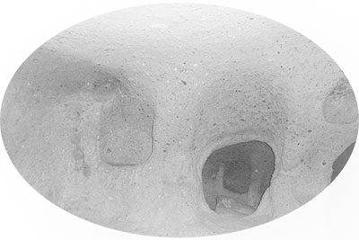
The underground city of Kaymakli is excavated within the soft volcanic tuff of southern Cappadocia. Its architecture depends entirely on the transformation of bedrock rather than on freestanding masonry construction. The visible settlement at ground level conceals an extensive excavated network below, where rooms, corridors, shafts, and storage spaces were carved directly into the geological mass. The material quality of the tuff determined both the feasibility and the limits of expansion: it could be cut with relative ease while retaining sufficient cohesion when dry.
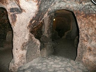
Kaymakli is organized through several superimposed levels linked by descending passages and vertical shafts. Only part of the total system is open to visitors, but the accessible sectors reveal a complex arrangement that grew through incremental enlargement rather than a single preconceived master plan. The plan is therefore irregular, with branches, constrictions, widened chambers, and abrupt directional changes. This apparent complexity reflects practical adaptation to rock conditions, structural safety, and changing functions.
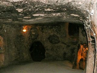
The circulation pattern avoids long straight axes. Instead, movement is guided through short segments, turns, and controlled thresholds. Spatial experience is based on alternating compression and expansion: narrow passages open suddenly into larger chambers, then contract again into steep connectors. This rhythm is one of the defining architectural characteristics of Kaymakli.
Excavation Methods and Structural Control
Kaymakli was created by subtractive construction. Builders removed rock while preserving enough material to act as walls, ceilings, pillars, and load-bearing masses. Structural stability depended on empirical knowledge of the tuff: how far a chamber could be widened, where support masses needed to remain, and which zones were suitable for deeper excavation.
Ceilings vary according to span and use. Small passages often have rounded or barrel-like profiles formed by practical cutting methods. In wider rooms, ceilings may be flatter or slightly domed depending on the thickness of rock above. Heights are inconsistent, indicating that dimensions were adapted to purpose rather than standardized. Some corridors require a bent posture, while storage chambers and gathering spaces provide more generous clearance.
Floors, ramps, and steps are carved from the same rock body. Their surfaces can be worn, irregular, or steep, showing functional use over long periods rather than formal finish. Stair-like descents are often narrow, reducing the number of people who could move simultaneously. This had both practical and defensive value.
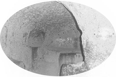
Because the city was excavated rather than assembled, joints, seams, and separate structural members are largely absent. Architectural expression comes from carved mass, void, and texture rather than from added ornament. Tool marks and smoothed surfaces in some sectors reveal successive working phases and later refinements.
Internal Distribution and Functional Spaces
Kaymakli’s accessible levels show a clear hierarchy of use. Upper zones nearest the surface contain spaces generally interpreted as stables, service rooms, and storage chambers. Their location would have eased the movement of animals, provisions, and goods into the underground system. Lower sectors offered increased security, more stable temperatures, and greater separation from entrances.
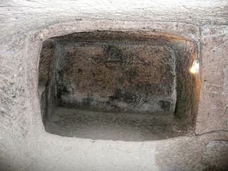
Storage rooms are among the most legible spaces. Many are regular in shape and include niches, benches, recesses, or cut platforms suitable for jars and containers. The constant subterranean climate would have favored preservation of grain, produce, and other supplies. Some chambers contain circular depressions or installations associated with food processing.
Domestic or temporary living areas are larger and more varied in plan. These rooms sometimes include raised ledges, wall niches, or broader floor areas suitable for occupation. Their arrangement does not reproduce above-ground houses in formal terms. Instead, it condenses essential functions into compact excavated volumes.
The city also includes working spaces connected to production and daily maintenance. Pressing areas, storage cells, kitchens, and utility rooms have been identified in different parts of the complex. Their presence indicates that Kaymakli could support sustained occupation during periods of refuge rather than only brief emergency shelter.
Connections between rooms are carefully staged. Side chambers branch from main routes, while dead ends and narrow connectors help segment circulation. This compartmentalization meant that one part of the network could be isolated without rendering the whole unusable.
Defensive Devices, Ventilation, and Technical Systems
One of the most distinctive architectural elements of Kaymakli is the circular stone door. These large disk-shaped slabs were positioned at strategic corridor entrances and could be rolled into place to block passage. Their dimensions, thickness, and weight made them effective barriers within already constricted routes. Small central openings in some examples may have allowed observation, communication, or limited airflow.
The defensive system did not rely on monumental walls but on geometry. Narrow passages, sharp turns, descending slopes, and compartmentalized levels slowed movement and favored inhabitants familiar with the layout. The underground plan itself functioned as a protective mechanism.
Ventilation was essential to habitability. Vertical shafts cut through multiple levels introduced air and sometimes connected with the surface. These shafts also served as communication lines and, in certain cases, may have assisted access to water sources. Their placement demonstrates technical understanding of airflow within a deep enclosed system.
Lighting originally depended on portable lamps rather than fixed architectural openings. As a result, chambers were designed without the need for windows or large exterior apertures. This reinforced concealment and structural continuity while increasing dependence on organized internal movement.
Water management was equally important. Some wells or shafts were likely integrated into the underground network, allowing occupation without immediate surface exposure. In a defensive context, secure access to water would have been critical.
Modifications, Present Readability, and Conservation
Kaymakli is a cumulative architecture shaped by repeated adaptation. Certain rooms were enlarged, others subdivided, and some corridors re-cut or abandoned. Variations in finish, section width, and spatial coherence suggest multiple excavation campaigns over long periods. The site should therefore be read as an evolving system rather than a static design.
Modern access has required selective intervention. Paths have been stabilized, lighting introduced, unsafe passages closed, and visitor circulation directed through representative zones. These additions are generally restrained so that the carved spaces remain visually dominant. Large portions of the total network remain inaccessible because of fragility, complexity, or conservation priorities.
Preservation challenges are primarily structural and environmental. Tuff can deteriorate through moisture fluctuation, vibration, and constant abrasion from visitors. Floors become polished, edges wear down, and local microclimates may change with heavy traffic. Conservation therefore depends on monitoring humidity, limiting overcrowding, reinforcing vulnerable sectors, and controlling routes through the monument.
The architectural significance of Kaymakli lies in the successful conversion of a geological formation into a fully integrated subterranean habitat. Storage, circulation, defense, ventilation, and temporary residence were all accommodated within a continuous carved structure whose coherence emerges from function rather than visual monumentality.