
 Français (France)
  Nederlands (nl-NL)
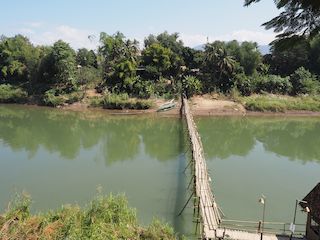
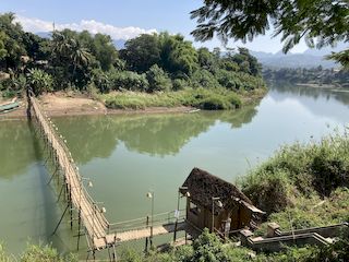
 The bamboo bridge over the Mekong in Luang Prabang, Laos, is a seasonal pedestrian structure connecting parts of the city with areas located on the opposite bank of the river during the dry season. Built from locally available materials, the bridge provides a temporary crossing used by residents and visitors. The structure usually disappears or is dismantled when water levels rise during the rainy season and is reconstructed once conditions permit. Today the bamboo bridge is recognized as a distinctive feature of the river landscape of Luang Prabang and reflects local adaptations to the seasonal fluctuations of the Mekong.

Luang Prabang • Bamboo bridge over the Nam Khan
Luang Prabang • Bamboo bridge over the Nam Khan
Luang Prabang • Bamboo bridge over the Nam Khan
Monument profile
Bamboo bridge over the Nam Khan
Monument category: Bridge
Monument family: Civil engineering structures (bridges, wells, etc.) and factories
Monument genre: Economic
Geographic location: Luang Prabang • Laos
Construction period: 16th century AD
• Links to •
• List of videos about Luang Prabang on this site •
Luang Prabang, Royal Palace • Laos
Luang Prabang, the markets • Laos
Luang Prabang, Wat Sensoukharam temple • Laos
Luang Prabang, Sunset on Mount Phou Si • Laos
Luang Prabang, Wat Xieng Thong temple • Laos
Luang Prabang, paper making workshop • Laos
Laos • Fabric Arts
Luang Prabang, a City in the Countryside • Laos
Luang Prabang, some temples • Laos
History of the Bamboo Bridge over the Mekong in Luang Prabang
Origin and Establishment of the Seasonal Crossing
The bamboo bridge constructed each year across the Mekong River in Luang Prabang developed as a practical response to the seasonal variations of the river and to the need for a direct pedestrian connection between the historic town and the opposite riverbank. During the dry season, when the water level of the Mekong decreases significantly, sandbanks and shallow sections of the riverbed become accessible, allowing the installation of temporary structures supported by bamboo piles.
Local entrepreneurs and small groups of workers typically organize the construction of the bridge. The initiative is generally private rather than governmental, and the project is implemented at the beginning of the dry season once river conditions allow stable anchoring of vertical supports. The bridge provides a direct route between the urban peninsula of Luang Prabang and areas across the river that include agricultural land, temporary riverside markets, and recreational zones.
The placement of the crossing is influenced by the configuration of the riverbanks and by the presence of shallow sections of the riverbed suitable for installing rows of bamboo supports. The resulting structure functions as a seasonal infrastructure that complements traditional boat crossings used throughout the year.
Construction Practices and Operation
The construction of the bamboo bridge requires coordinated manual labor and familiarity with local building techniques based on bamboo assembly. Workers drive bamboo poles into the riverbed to form rows of vertical supports. These poles are positioned at regular intervals along the planned route of the bridge and provide the primary structural stability of the crossing.
Horizontal bamboo elements are then attached to these supports using tightly bound ligatures made from rope or synthetic cords. This framework forms the structural skeleton of the bridge. A deck composed of bamboo slats or split bamboo sections is installed on top of the framework, creating a continuous walking surface for pedestrians.
Once completed, the bridge is opened for daily use. In many years a modest toll is collected from those crossing the bridge, which helps finance construction costs and maintenance throughout the dry season. The bridge facilitates daily activities by allowing residents to reach cultivated land, river beaches, or neighboring settlements more easily than by boat.
The structure remains in use throughout the months when the Mekong maintains a relatively low level. Periodic repairs are carried out during this time to replace damaged bamboo sections or reinforce structural elements weakened by constant use.
Evolution of Use and Interaction with Tourism
The function of the bamboo bridge changed significantly as Luang Prabang developed into an international tourist destination in the late twentieth century. Visitors increasingly used the crossing not only as a means of transportation but also as a vantage point from which to observe the river landscape and the surrounding mountains.
The bridge gradually became part of the experience of exploring the Mekong riverfront during the dry season. Tourists frequently cross the structure to reach temporary riverside cafés, sandbanks, or viewpoints located across the river from the historic town. This additional use strengthened the economic importance of rebuilding the bridge each year.
Despite the growing role of tourism, the bridge continues to maintain its practical function as a local crossing. Residents of Luang Prabang still use the structure for everyday movement between the town and areas situated across the river.
The temporary nature of the bridge remains unchanged. When the rainy season begins and the Mekong rises rapidly, the structure becomes vulnerable to strong currents and floating debris. The bridge is therefore dismantled or abandoned before the highest water levels occur, preventing the destruction of the entire structure.
Global Historical Context
The modern reconstruction of the bamboo bridge in Luang Prabang coincides with a period of increasing international attention to Southeast Asian historic cities. During the 1990s several urban centers in the region gained recognition for their cultural and architectural significance. In 1995 the historic town of Luang Prabang was inscribed on the UNESCO World Heritage List for the exceptional preservation of its urban landscape and religious architecture. The growing international visibility of the city contributed to the broader recognition of local riverfront practices and seasonal structures associated with the Mekong.
Present Role and Preservation
Today the bamboo bridge remains a seasonal infrastructure reconstructed each year during the dry season. Its continued existence depends on favorable hydrological conditions, the availability of bamboo materials, and the economic viability of rebuilding the crossing.
The structure is used simultaneously by local residents and visitors, serving as both a practical route across the Mekong and a recognizable feature of the river environment surrounding the historic city. The annual reconstruction of the bridge preserves local knowledge related to bamboo construction techniques and maintains a traditional approach to adapting infrastructure to the seasonal behavior of the Mekong River.
Although the bridge itself is not individually inscribed as a World Heritage monument, it stands within the broader landscape of Luang Prabang, whose historic center has been recognized by UNESCO since 1995. The presence of the bamboo bridge contributes to the dynamic relationship between the town and the river that has long shaped the spatial organization of the city.
Architecture of the Bamboo Bridge over the Mekong in Luang Prabang
Site Placement and Overall Structural Layout
The bamboo bridge constructed seasonally across the Mekong River in Luang Prabang is positioned between the riverbank of the historic peninsula and exposed sandbanks or shallow areas on the opposite side of the river. Its location is determined by the geometry of the river channel during the dry season, when the water level drops sufficiently to reveal stable sections of the riverbed capable of supporting vertical supports.
The bridge extends in a generally linear direction across the river, though minor deviations may occur where the line of supports must avoid deeper channels or stronger currents. The alignment is carefully chosen to connect two accessible points on the riverbanks while minimizing the structural stress caused by the movement of water.
The crossing usually measures several hundred meters in length, depending on the seasonal width of the exposed river channel. The walkway is narrow, typically designed to accommodate pedestrian circulation and occasional bicycles. This limited width reduces structural load and allows the use of slender bamboo elements without compromising the stability of the bridge.
Access points on both banks are designed as transitional zones where the ground level meets the elevated deck of the bridge. These areas often incorporate reinforced bamboo frameworks forming short ramps or raised platforms that distribute the concentrated loads created by groups of pedestrians entering or leaving the bridge.
Structural System and Construction Techniques
The structural framework of the bamboo bridge is composed of vertical piles driven into the sediment of the Mekong riverbed. These piles are formed from thick bamboo poles selected for their structural rigidity and length. They are installed manually by driving them into the sandy or silty substrate until sufficient resistance is achieved to stabilize the structure.
Rows of these vertical piles form the primary supports of the bridge. The spacing between the supports is determined by the expected load on the deck and by the strength of the bamboo elements available. Each row of piles typically supports a segment of the bridge deck, creating a series of short spans that distribute weight along the structure.
Horizontal bamboo beams are attached to the tops of the vertical supports to create a longitudinal framework. These beams are fastened using tightly bound ligatures made from rope or synthetic cord, which hold the bamboo elements together without the need for metal fasteners. The flexibility of these connections allows the structure to absorb minor movements caused by water flow and pedestrian traffic.
On top of this supporting framework lies the walking surface. The deck is composed of bamboo slats or split bamboo sections arranged perpendicular to the direction of the bridge. These elements create a continuous walkway while allowing slight gaps between pieces, which reduce wind resistance and allow water to pass through if the river level rises temporarily.
Materials and Structural Behavior
The entire structure relies almost exclusively on bamboo, a material readily available in the region and well suited to temporary river structures. The bamboo poles used for structural supports possess a high strength-to-weight ratio, enabling them to sustain vertical loads while remaining easy to transport and assemble on site.
The cylindrical geometry of bamboo provides resistance to compression forces when used as vertical piles. At the same time, the natural elasticity of the material enables it to bend slightly without fracturing under dynamic loads such as pedestrian movement or river currents. This elasticity is particularly valuable in a structure exposed to fluctuating environmental conditions.
Horizontal bamboo members contribute to load distribution along the length of the bridge. Because bamboo is lightweight, the entire structure maintains a relatively low mass, reducing the risk of collapse if certain elements are weakened or temporarily displaced by environmental forces.
The visual appearance of the bridge is defined by the natural color and texture of untreated bamboo. The poles and slats gradually change in tone as they are exposed to sunlight and humidity, producing a surface that evolves throughout the months of use. This material continuity gives the structure a uniform appearance across its entire length.
Spatial Organization and Functional Elements
The bridge is organized as a sequence of modular spans defined by the spacing of the vertical supports. Each span corresponds to the distance between two sets of pile rows, creating a repetitive structural rhythm along the length of the crossing. This modular arrangement allows builders to adjust the total length of the bridge depending on the seasonal configuration of the river.
In certain segments the deck may be slightly elevated relative to neighboring sections. These variations in height help maintain a safe clearance above shallow water channels that remain active during the dry season. They are achieved by installing longer vertical supports and repositioning the horizontal beams that carry the deck.
Passing points are occasionally incorporated along the bridge where the walkway widens slightly. These areas allow pedestrians traveling in opposite directions to pass without forcing one group to step aside onto narrower parts of the structure.
Simple guardrails may be installed in selected areas where the river depth below the bridge remains significant. These guardrails consist of vertical bamboo stakes connected by horizontal rails, forming a minimal protective barrier along the edges of the walkway.
Seasonal Adaptation and Structural Renewal
The architecture of the bamboo bridge is fundamentally linked to the seasonal hydrology of the Mekong River. The structure is designed to function only during the dry season, when water levels are sufficiently low to permit stable installation of bamboo piles in the riverbed.
As the rainy season approaches, the rising water level and stronger currents pose increasing risks to the stability of the bridge. Floating debris carried by the river can strike the supports, while higher flow velocities can undermine the foundations of the piles. For this reason, the bridge is typically dismantled before peak flood levels occur.
Many bamboo elements can be recovered and reused during the following construction cycle. Workers remove the deck components and structural beams before extracting or abandoning the vertical piles embedded in the sediment. The reconstruction of the bridge during the next dry season follows a similar structural layout, though the exact alignment may vary depending on the river’s configuration that year.
This cycle of assembly, use, dismantling, and reconstruction defines the architectural character of the bamboo bridge. Rather than representing a permanent structure, it functions as a recurring seasonal infrastructure that adapts each year to the shifting physical conditions of the Mekong River near Luang Prabang.