
 Français (France)
  Nederlands (nl-NL)
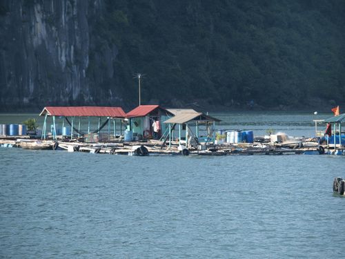
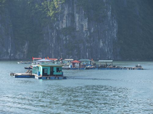
 The floating villages of Ha Long Bay in Vietnam represent a distinctive form of settlement built directly on the water. Characterized by floating houses, small boats, and community spaces designed for aquatic conditions, these villages reflect a lifestyle closely linked to fishing and water-based trade. They illustrate an adaptation to the maritime environment and provide a cultural dimension to the bay, which is internationally renowned for its striking seascapes and recognized as a UNESCO World Heritage Site.
Halong Bay • Floating Villages
Halong Bay • Floating Villages
Halong Bay • Floating Villages
Natural site profile
Floating Villages
Natural site category: Floating villages
Natural site family: Seas, lakes and rivers
Natural site genre: Aquatic
Geographic location: Halong Bay • Vietnam
• Links to •
• List of videos about Halong Bay on this site •
Halong Bay • Vietnam
Floating Villages of Ha Long Bay: Preservation Drivers, Transformations, and Contemporary Challenges
Drivers of preservation and valorization
The preservation of the floating villages in Ha Long Bay has been shaped by intersecting political, economic, and cultural priorities. Politically, Vietnam has sought to safeguard a nationally emblematic seascape while aligning local governance with international conservation standards. Economically, the bay’s tourism potential—built on striking karst scenery and a distinctive water-based way of life—encouraged policies that balance visitor revenue with long-term environmental quality. Culturally, the villages embody a maritime livelihood adapted to tidal rhythms, small-scale fisheries, and inter-island trade; their visibility reinforces regional identity and offers a living testimony to human adaptation within a sensitive coastal ecosystem.
When the process began
Institutionalized preservation took shape in the 1990s, when formal protection frameworks were strengthened and the bay’s international recognition accelerated conservation planning. From that period onward, provincial and national authorities introduced zoning, navigation controls, and limits on extractive activities, while piloting waste-management and education measures within the villages.
Historic milestones and regional effects
Key milestones include the establishment of stricter marine protected zones, the consolidation of tourism management (licensing, route planning, overnight permits), and phased relocation or partial resettlement of households from the most sensitive areas to shore-based settlements. These steps sought to reduce direct pressures on coral, seagrass, and mangrove habitats; improve safety, schooling, and healthcare access for residents; and enhance water quality in sheltered lagoons. Regionally, such measures supported a shift from largely unregulated harvesting toward diversified livelihoods—boat services, artisanal aquaculture in designated areas, hospitality, and cultural interpretation—helping the province reposition its economy around higher-value, environmentally aware tourism.
Global context and comparative perspective
These developments unfolded as coastal nations worldwide grappled with sustainable development after the early-1990s environmental summits. Ha Long’s approach parallels management dilemmas seen in other inhabited waterscapes: the Uros communities on Lake Titicaca, stilt settlements on Lake Nokoué in West Africa, or lagoon villages in parts of Southeast Asia. In each case, authorities confront similar trade-offs—protecting fragile aquatic ecosystems; recognizing heritage values of water-based cultures; and ensuring that residents benefit from tourism without being displaced or reduced to purely touristic displays. Compared with some peers, Ha Long Bay has moved relatively quickly to formalize carrying-capacity rules for cruise routes and to integrate livelihood transitions (for example, retraining programs and shore facilities) into conservation agendas. Yet, as elsewhere, enforcement consistency and equitable benefit distribution remain recurring challenges.
Transformations over time
Over centuries, the villages have evolved from loosely clustered fishing hamlets to more structured communities with floating homes, fish cages, and communal platforms. In recent decades, three transformations stand out:
- Spatial reconfiguration: Certain clusters were consolidated or relocated to reduce ecological stress near sensitive reefs and caves. The resulting lower density on the water has eased localized pollution but altered social networks and daily mobility patterns.
- Economic diversification: Traditional capture fisheries were complemented—and, in some zones, partially replaced—by regulated aquaculture and tourism services. This reduced pressure on wild stocks but introduced new concerns about feed inputs, waste, and the visual impact of infrastructure.
- Governance formalization: Local customary norms have been progressively integrated with formal rules on navigation, licensing, and waste handling. While this improved safety and environmental oversight, it also demanded new administrative capacities and posed questions about cultural continuity.
These shifts mirror broader environmental, political, and cultural changes: rising sea temperatures and extreme weather events; stricter national coastal policies; and worldwide demand for experiential tourism that foregrounds local cultures.
Ecological and symbolic significance
Ecologically, the villages interface with mangroves, seagrass meadows, and coral communities typical of a tropical karst bay. Lower-energy coves support nursery habitats for fish and invertebrates; limestone islets host specialized flora and roosts for seabirds; and tidal exchanges sustain a mosaic of micro-habitats. Human presence can be a stressor, but village-level knowledge—timing of fishing, storm avoidance, small-boat navigation—has historically moderated impacts through low-tech, low-energy practices. Symbolically, the villages give a human scale to a grand seascape, turning geological drama into a lived environment. This coupling of natural form and cultural adaptation has been central to the site’s international reputation and educational value.
Current condition and management challenges
Overall condition is the result of ongoing trade-offs. Water quality and habitat integrity have benefited from zoning, improved waste protocols, and caps on vessel density along popular routes. Some remaining floating hamlets serve as cultural anchors and interpretation sites, helping visitors understand maritime lifeways beyond scenic appreciation. At the same time, several challenges persist:
- Tourism pressure and carrying capacity: Peak-season congestion strains waste systems, increases anchor damage risks, and amplifies noise and wake effects on sensitive shores. Enforcing route dispersion, mooring buoys, and strict vessel standards is essential.
- Pollution and resource inputs: Even regulated aquaculture can introduce nutrients and plastics; household waste management on water remains logistically complex. Continuous monitoring and incentives for cleaner materials and closed-loop systems are needed.
- Climate change: Sea-level rise, storm intensity, and ocean warming threaten corals, intertidal vegetation, and infrastructure. Adaptation plans—elevated or modular platforms, early-warning systems, and refuge protocols—are increasingly important.
- Social equity and cultural continuity: Relocation policies and market shifts can marginalize residents if not paired with secure tenure options, training, and revenue-sharing mechanisms. Preserving intangible knowledge—boat craft, tidal reading, net types—requires documentation and community-led curation, not only display for visitors.
- Governance coherence: Multiple agencies oversee navigation, fisheries, conservation, and tourism. Harmonized data, joint inspections, and transparent reporting improve compliance and trust among operators and residents alike.
Outlook
The floating villages of Ha Long Bay endure as a rare synthesis of dramatic karst geomorphology and a maritime culture adapted to it. Their preservation hinges on practical measures—capacity limits, clean-water infrastructure, resilient moorings—as much as on cultural policies that keep resident communities central to decision-making. If managed with rigor and empathy, the villages can remain both a living heritage and a benchmark for integrated coastal stewardship, demonstrating how ecological integrity, cultural vitality, and regional prosperity can reinforce rather than undermine one another.
Floating Villages of Ha Long Bay: Geological Innovation, Ecological Wealth, and Global Recognition
Geological foundations and the making of a drowned karst seascape
Ha Long Bay’s floating villages occupy one of the world’s most emblematic karst environments. The bay extends over roughly 1,500 square kilometres and contains nearly 2,000 limestone islands and islets. Its carbonate bedrock was laid down in warm, shallow seas, then uplifted, jointed and slowly dissolved along fractures by rainfall and groundwater. During the Quaternary, repeated sea-level oscillations flooded valleys and isolated residual towers, producing a “drowned karst” panorama of vertical cliffs, natural arches, caves, dolines and enclosed basins. The landscape is not static: tidal range, storm waves and seasonal runoff continue to widen joints, undercut ledges and reshape talus slopes, making the bay a live demonstration of tropical marine karst evolution.
Topography as an engine of ecological diversity
The bay’s three-dimensional relief generates a dense array of microhabitats. Sheer limestone walls provide ledges and crevices used by seabirds; protected coves and lagoon-like embayments function as nurseries for juvenile fish and crustaceans; shallow shelves favour seagrass, while clearer, well-flushed channels promote coral growth. Inside semi-submerged grottoes, reduced light and wave energy sustain specialised communities of algae and invertebrates. On the islands, thin calcareous soils host stress-tolerant plants adapted to salt spray and intermittent drought. The fine-grained spatial variation in exposure, depth, salinity and light turns the seascape into a mosaic of niches, where small changes in topography translate into distinct ecological assemblages.
Biological richness and functional linkages
Ha Long Bay supports notable biodiversity. Scientific inventories record more than five hundred fish species and nearly two hundred mollusks, alongside numerous crustaceans and echinoderms. Mangrove stands fringe parts of the shoreline, buffering erosion, trapping sediments and exporting leaves and detritus that fuel coastal food webs. Seagrass meadows oxygenate water and stabilise the seabed; coral reefs add structural complexity that increases habitat heterogeneity and supports reef-associated fishes. Migratory birds and pelagic species periodically traverse the bay, linking it to regional flyways and marine corridors. The coexistence of endemic taxa with transient populations highlights both the site’s uniqueness and its integration into wider ecological networks, where productivity depends on the flow of nutrients and organisms between habitats.
Human adaptation in a dynamic environment
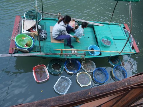
The floating villages add a cultural layer to this natural stage. For generations, residents built wooden houses on buoyant platforms moored in calm lagoons or at the base of limestone towers. Livelihoods revolved around near-shore fishing, small-scale aquaculture and boat-borne trade, supported by repair crafts carried out on communal platforms. Everyday decisions—routes, gear choice and even school timetables—were synchronised with tides, monsoon winds and seasonal cycles. This aquatic way of life minimised pressure on scarce flat land while keeping families close to fishing grounds. It also fostered precise environmental knowledge: reading sky and swell, navigating in narrow channels, and rotating effort across seasons to reduce localised stress on stocks.
Local processes and global pressures
While the bay’s character stems from local geology and oceanography, it is increasingly shaped by global forces. Rising temperatures and altered storm tracks influence coral health, mangrove stability and plankton dynamics; sea-level rise threatens low-lying platforms and intertidal habitats. International tourism amplifies both opportunity and risk: revenues can support conservation and community services, yet congestion and waste may exceed carrying capacity unless routes, moorings and vessel standards are tightly managed. The floating villages thus stand at the meeting point of local natural processes and planetary trends, a duality that explains both their vulnerability and their symbolic appeal.
Notable features, statistics, and anecdotes
Historically, about 1,600 residents lived across several floating settlements, with Cua Van often cited as the largest, at times around 700 inhabitants. Daily life unfolded on water: children rowed to floating schools; fish cages hung beneath homes; markets and net repairs took place on shared platforms; and small boats served as “streets” linking households. In recent decades, some families moved to shore to gain better access to education, healthcare and sanitation, while a number of floating hamlets continue as living heritage and interpretation sites. The bay now welcomes millions of visitors annually, drawn by the combination of geological drama and a water-based culture that gives the seascape a distinct human dimension.
Comparisons and points of contrast
Water-based communities occur elsewhere—the reed islands of the Uros on Lake Titicaca, the stilt settlements on Lake Nokoué in Benin and lacustrine villages on Cambodia’s Tonlé Sap. Each demonstrates ingenuity in adapting to aquatic settings; yet Ha Long Bay stands apart for the scale and sharp relief of its limestone towers and for the tight coupling of geology and ecology in a coastal sea. Few places combine pinnacles, tidal lagoons, caves, mangroves, seagrass and floating neighbourhoods with comparable coherence. The international parallels also reveal shared challenges: safeguarding biodiversity, maintaining water quality, ensuring resident benefits from tourism and avoiding the reduction of communities to static “displays”.
World recognition and conservation outcomes
The bay’s global profile reflects both natural splendour and scientific interest. Its inscription on the World Heritage List in 1994 for outstanding scenic value, followed by an extension in 2000 acknowledging geological significance, raised expectations for careful stewardship. A further expansion in 2023 to include the Cat Ba Archipelago broadened the management frame and promoted coordinated planning across adjacent islands and channels. These milestones backed tighter controls on waste and vessel density, the installation of mooring buoys to limit anchor damage, monitoring of coral and seagrass, and education programmes for operators and visitors. International recognition also clarified that the floating villages form part of a living landscape, where cultural practices and ecosystem processes are managed together.
Current condition and forward risks
Management has yielded gains in core zones: cleaner water along popular routes, clearer licensing for cruise operations and homestays, and better separation between sensitive reefs and anchoring areas. Still, vulnerabilities persist. Even regulated aquaculture can introduce nutrients and plastics; wakes from poorly handled boats erode soft shores; engine noise and bright lights disturb wildlife. Climate hazards—stronger storms, heat stress on corals, ocean acidification and gradual sea-level rise—compound these pressures. Socially, relocation and market shifts risk eroding intangible knowledge unless communities remain central to decision-making, with secure tenure options, training and fair participation in tourism revenues.
Why the site matters today
The floating villages of Ha Long Bay crystallise a rare synthesis: geological innovation carved in limestone; ecological wealth sustained by mangrove, seagrass and coral; and human know-how honed to the rhythms of a demanding environment. The same qualities that earned international attention now require disciplined care. If management continues to connect science, community experience and visitor practices—capacity limits, clean-water infrastructure, resilient moorings, transparent reporting—the bay can remain a benchmark for integrated coastal conservation. In doing so, it will demonstrate that natural grandeur and living heritage can reinforce one another, sustaining biodiversity, cultural vitality and regional prosperity in the face of changing seas.