Français (France)
  Nederlands (nl-NL)
 Devrent Valley is one of the best-known landscapes of Cappadocia in central Turkey. The site is especially appreciated for the variety of its rock forms and for the distinctive appearance of landforms shaped over time. Unlike other inhabited areas of the region, Devrent is mainly known for its scenic character and for the clear visibility of natural processes on the ground. The valley provides a representative view of major Cappadocian landscapes and attracts visitors, photographers, and geology enthusiasts. It contributes significantly to the international image of modern Cappadocia.
Cappadocia •
Cappadocia •
Cappadocia •
Natural site profile
Natural site category: Fairy chimneys
Natural site family: Natural volcanic sculptures
Natural site genre: Terrestrial
Geographic location: Cappadocia • Turkey
This natural site in Cappadocia is inscribed on the UNESCO World Heritage List since 1985 and is part of the serial property "Göreme National Park and the Rock Sites of Cappadocia".See the UNESCO natural sites featured on this site
• Links to •
• List of videos about Cappadocia on this site •
Cappadoce • Göreme, valleys and cave villages Turkey
Devrent Valley: recognition and preservation of a sculpted landscape in Cappadocia
A natural landscape that became emblematic
Devrent Valley is one of the most recognizable landscapes of Cappadocia in central Anatolia. Unlike other parts of the region known for cave settlements, rock-cut churches, or long-inhabited villages, this site is distinguished primarily by the visual power of its natural landforms. Rolling ridges, isolated cones, and rock silhouettes shaped by erosion have made it a representative image of Cappadocia on the international stage.
For many centuries, the valley formed part of the ordinary rural environment. It was crossed, observed, and occasionally used within a territory structured by agriculture, livestock raising, and movement between settlements. Its importance was therefore linked less to formal heritage ideas than to its place within the daily landscape of local communities.
From local perception to outside interest
A major change came in the modern era, when travellers, researchers, and artists began paying closer attention to the unusual landscapes of Anatolia. From the nineteenth century, and especially during the twentieth, Cappadocia gradually attracted international interest for its geological diversity and the close relationship between spectacular scenery and long human occupation.
Within this broader context, Devrent Valley gained particular visibility. Its clearly legible relief and the presence of rocks that appear to resemble animals, human figures, or familiar objects created immediate appeal. This easily recognizable character helped spread the image of the valley through photography, travel literature, and later mass tourism.
Public authorities increasingly understood the value of such landscapes. Preserving them could strengthen the heritage profile of the region, encourage cultural tourism, and support local economic development. Devrent thus became part of a wider movement recognizing outstanding natural scenery as a resource worth protecting.
Twentieth-century heritage development
During the twentieth century, the protection of major natural and cultural sites became an international priority. Many countries established parks, protected zones, and conservation policies. In Turkey, Cappadocia benefited from this wider trend. Attention was directed not only toward monuments and archaeological remains, but also toward exceptional geological landscapes.
Devrent Valley benefited directly from this shift. Its inclusion within the broader Cappadocian heritage area increased its reputation. The site became a regular stop on regional itineraries, alongside other famous valleys. Its value lay in its ability to illustrate quickly and clearly the natural processes that shaped the region.
This evolution can be compared with developments in other scenic landscapes worldwide where geology plays a central role, including canyons, volcanic plateaus, desert formations, and erosion-sculpted rock fields. As elsewhere, tourism growth gradually led to stronger conservation concerns.
Economic and social transformations
Growing visitor numbers changed the function of the valley significantly. What had once been a secondary rural space became a recognized destination. This transformation supported the surrounding economy through transport, restaurants, accommodation, crafts, and visitor services.
Socially, the international reputation of Cappadocia strengthened regional awareness of landscape heritage. Landforms once considered ordinary elements of the countryside came to be viewed as symbols of local identity. Devrent Valley plays an important part in that changing perception.
At the same time, the tourism economy created new dependencies linked to seasonal demand and fluctuations in international travel.
Present importance and symbolic image
Today, Devrent Valley represents one of the best-known visual symbols of modern Cappadocia. It illustrates the ability of natural forces to create forms resembling monumental sculpture without direct human intervention. Much of its appeal lies in observation, visual interpretation, and the immediate readability of the terrain.
The site also has educational value. It offers a clear introduction to the combined effects of ancient volcanism, slow erosion, and continental climate on landscape formation.
Conservation challenges
The general state of preservation remains favourable, but the softness of the rock requires constant attention. Tuff formations are vulnerable to natural erosion, repeated trampling, uncontrolled movement across sensitive areas, and excessive infrastructure.
Climate change may create additional pressures through stronger rainfall events, drought periods, or more pronounced freeze-thaw cycles. The long-term future of the valley therefore depends on sustainable management combining landscape protection, controlled visitation, and careful interpretation.
Devrent Valley demonstrates how an area once regarded simply as natural scenery can become recognized heritage with regional identity and international significance.
Devrent Valley: natural forms and sculpted landscapes of Cappadocia
Relief and spatial organization
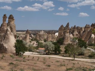
Devrent Valley lies within one of the most characteristic landscape zones of Cappadocia, a region of central Anatolia known for terrain shaped by ancient volcanism. The site appears as a succession of open shallow valleys, gentle slopes, low ridges, and isolated rock groups. Unlike some of the deeper or more enclosed valleys of the region, Devrent presents a relatively open and readable landscape where landforms can be observed immediately across broad space.
The terrain alternates between rolling surfaces, natural corridors, and slightly elevated points that function as viewpoints. This topography allows wide visual understanding of the site and makes the main rock formations easy to identify.
A volcanic origin transformed by erosion
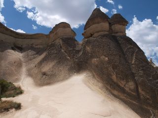
Like the wider Cappadocian region, the valley is based on ancient volcanic deposits created by major eruptions millions of years ago. Ash, pumice, and pyroclastic material accumulated in thick layers before consolidating into volcanic tuff. This relatively soft rock was then slowly reshaped by natural forces.
Rainfall, runoff, wind, temperature contrast, and freeze-thaw action gradually carved the original plateau. More fragile zones eroded faster, while other masses remained in relief. This mechanism explains the wide variety of forms visible today.
Dominant colours range from pale beige to light pink, sometimes mixed with ochre or grey according to mineral composition and changing light conditions.
Fairy chimneys and natural sculpture
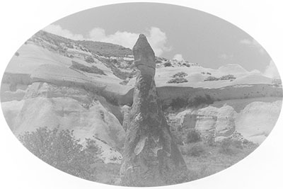
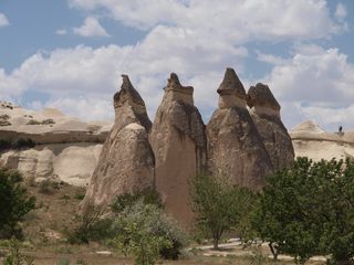
Devrent Valley is especially known for its evocative rock forms. Many fairy chimneys can be seen across the area. These are columns of tuff isolated by erosion, sometimes capped by a harder stone that slows weathering. Their height and shape vary greatly from one sector to another.
The valley is particularly famous for landforms whose outlines resemble animals, human figures, or familiar objects. This quality of visual suggestion distinguishes Devrent from other Cappadocian valleys more strongly associated with cave dwellings or historical remains.
Among the best-known examples are shapes often compared to a camel, a seal, or other figures depending on angle, distance, and lighting. Such interpretations are subjective, but they form part of the valley’s identity.
Rock surfaces, soils, and active landscape processes
Soils are generally dry, stony, and shallow on the slopes. In flatter areas, finer sediments may accumulate and support more vegetation. Gullies and small channels show the continuing action of runoff, especially after short but intense rainfall.
Rock surfaces display fissures, cavities, rounded edges, and minor ledges that reveal ongoing weathering. The landscape is therefore still active from a geomorphological perspective: although changes are slow, natural forms continue to evolve.
Vegetation and living environments
The valley belongs to a semi-arid inland Anatolian environment. Natural vegetation remains modest and includes seasonal grasses, hardy shrubs, and drought-tolerant plants adapted to poor soils. In spring, some sectors become greener before returning to a more mineral appearance in summer.
Rock cavities and open ground may shelter small birds, insects, and reptiles adapted to dry terrain. Open plateau conditions also favour common species typical of central Anatolia.
Biological interest here lies less in spectacular biodiversity than in the adaptation of life to a dry mineral environment.
Light, climate, and visual experience
The continental climate strongly influences the appearance of the valley. Dry summers provide excellent clarity for viewing landforms. In winter, snow or frost can highlight volumes and contours. Transitional seasons create contrasts between pale rock, darker soil, and temporary vegetation.
Low-angle light in the morning and late afternoon particularly enhances the natural sculptures. Shadows deepen hollows and emphasize outlines, increasing the impression that some rocks resemble living figures.
What distinguishes Devrent Valley
The uniqueness of Devrent Valley lies in the immediate readability of its natural forms. While many parts of Cappadocia combine landscape with cave architecture and settlement history, this valley places the creative force of erosion at the centre of attention.
It is a site where direct observation alone can explain the meeting of ancient volcanism, geological time, and human imagination. This combination of scientific interest and visual interpretation gives Devrent a distinctive place among the most recognized landscapes of Cappadocia.