
 Français (France)
  Nederlands (nl-NL)
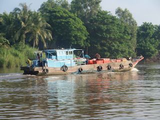
 The Mekong River, stretching about 4,350 kilometers, flows through China, Laos, Thailand, Cambodia, and Vietnam before reaching the South China Sea. It serves as a lifeline for Southeast Asia, supporting fisheries, agriculture, and transport for millions of people. Seasonal floods enrich the soil and sustain wetlands, particularly in Vietnam’s Mekong Delta. Both a source of prosperity and environmental concern, the river embodies the delicate balance between human activity and nature in the region.

Cambodge, Vietnam • The Mekong river: Mekong in Cambodia

Cambodge, Vietnam • The Mekong river: Mekong delta in Vietnam
Natural site profile
The Mekong river
Natural site category: River
Natural site family: Seas, lakes and rivers
Natural site genre: Aquatic
Geographic location: Cambodge, Vietnam • Laos
• Links to •
• List of videos about Mekong near Muang Champassak, Mekong near Luang Prabang, Mekong from Nakasong to Li Phi Somphamit on this site •
The Mekong: A Serene River? • Laos
The Mekong River: Balancing Nature, Development, and Regional Identity
A Lifeline Across Borders
The Mekong River, stretching over 4,300 kilometers, is one of the world’s most significant waterways, flowing through six countries — China, Myanmar, Laos, Thailand, Cambodia, and Vietnam. Its basin supports more than 60 million people who depend on it for fishing, farming, and transport. The river’s course from the Tibetan Plateau to the South China Sea links diverse landscapes and cultures, making it a vital ecological and cultural artery of Southeast Asia.
In Luang Prabang and Muang Champassak, the Mekong has long shaped local life. It served as both a natural boundary and a trade route connecting upland communities to lowland markets. Around Nakasong and Somphamit, the river’s countless channels and waterfalls — including the mighty Khone Phapheng Falls, the largest in Southeast Asia — illustrate the raw geological power of this system. These landscapes are not only spectacular but have historically dictated navigation, settlement, and regional identity.
Origins of Preservation Efforts
Efforts to study and manage the Mekong began under French colonial administration in the late 19th century. Between 1890 and 1930, hydrographic surveys sought to map the river’s navigable routes and exploit its economic potential. However, true environmental management emerged only in the mid-20th century. In 1957, the Mekong Committee, supported by the United Nations, became one of the first international river management initiatives. Its mission reflected a postwar vision of cooperation and modernization through water resources — irrigation, hydropower, and flood control — framed by the political tensions of the Cold War.
For newly independent nations such as Laos, Cambodia, and Vietnam, the river symbolized both sovereignty and opportunity. Each country viewed the Mekong as a cornerstone of national development. For landlocked Laos, it represented access to trade and energy. For Cambodia and Vietnam, it guaranteed food security and agricultural wealth. Over time, conservation concerns merged with political and economic goals, giving rise to a complex balance between resource exploitation and environmental preservation.
Economic Drivers and Development Policies
By the late 20th century, the Mekong had become central to the economic integration of mainland Southeast Asia. The fertile floodplains around Phnom Penh, the Tonlé Sap Lake, and the Mekong Delta formed the backbone of regional agriculture. The delta alone produces more than 20% of the world’s rice exports and sustains millions of livelihoods through aquaculture and farming.
Hydropower development soon followed. Starting in the 1990s, Laos adopted a national strategy to become the “battery of Southeast Asia,” constructing a series of large-scale hydroelectric dams, including Xayaburi and Don Sahong. These projects aimed to generate export revenue but also altered the river’s natural flow, disrupting sediment transport and fish migration.
This transformation mirrors global patterns: economic modernization often outpaces ecological foresight. Like the Nile in Africa or the Amazon in South America, the Mekong has become both a tool for development and a focus of environmental debate. The challenge lies in reconciling the river’s economic potential with its ecological fragility.
Cultural and Symbolic Dimensions
Culturally, the Mekong is deeply embedded in the spiritual and social fabric of Southeast Asia. In Buddhist tradition, the river embodies purity, renewal, and continuity. Rituals such as the Boun Souang Heua (boat races) in Laos and the Bon Om Touk festival in Cambodia celebrate the annual reversal of the river’s flow and the end of the rainy season. These events strengthen community ties and express reverence for water as a sacred element.
At Luang Prabang, a UNESCO World Heritage city, the river forms part of a living cultural landscape. The coexistence of monastic life, local markets, and river transport reflects a balance between tradition and modernity. Similarly, at Muang Champassak, near the ancient Wat Phou temple complex, the Mekong acts as both a geographic and spiritual axis, reinforcing the cultural unity of the region.
Environmental Transformations and Global Context
The Mekong’s ecological importance extends beyond national borders. Its interaction with Cambodia’s Tonlé Sap Lake is one of the most remarkable hydrological phenomena on Earth. Each year, during the monsoon, the river reverses direction and floods the lake, expanding its surface area sixfold — from 2,500 to more than 15,000 square kilometers. This cyclical process sustains the world’s most productive inland fishery, providing a crucial protein source for millions of people.
However, the river’s natural rhythm is increasingly disturbed. Dam construction, deforestation, and climate change have altered flood patterns, threatening ecosystems and traditional livelihoods. The Mekong Delta, once a symbol of fertility, now faces rapid coastal erosion, salinization, and subsidence. Scientists estimate that parts of the delta could sink below sea level by 2100 if current trends continue.
These transformations reflect a global issue: how to maintain river systems as engines of biodiversity in the face of human-driven change. Comparisons with the Danube River Basin in Europe highlight the value of cooperative frameworks like the Mekong River Commission (MRC), established in 1995, which promotes sustainable and equitable use of water resources among Laos, Thailand, Cambodia, and Vietnam.
Scientific Value and International Recognition
The Mekong basin is a natural laboratory for studying the interplay between geology, hydrology, and biology in tropical environments. The river’s sediment load, estimated at over 160 million tons per year, shapes deltas and floodplains that serve as habitats for thousands of species. Over 1,200 fish species have been identified, some — like the Mekong giant catfish — ranking among the largest freshwater fish on Earth.
While the Mekong itself is not listed as a UNESCO World Heritage Site, several of its associated ecosystems are internationally recognized. The Tonlé Sap Biosphere Reserve, designated by UNESCO in 1997, and the Ramsar-listed wetlands of the Vietnamese delta highlight global concern for the river’s ecological role. These designations have increased funding for research, environmental education, and habitat restoration. They also underscore the Mekong’s status as a transboundary ecological treasure, comparable to the Okavango or the Pantanal.
Political Cooperation and Regional Challenges
Managing the Mekong’s future requires navigating complex political terrain. The Mekong River Commission remains central to regional coordination, though its authority is limited by the absence of China and Myanmar, which control the river’s headwaters. China’s cascade of upstream dams on the Lancang River (the Chinese name for the upper Mekong) has been linked to declining water levels downstream, sparking diplomatic tension.
Recent initiatives, such as the Mekong-Lancang Cooperation Mechanism (2016), seek to align Chinese projects with regional needs, but asymmetries persist. Similar to the management of the Nile or the Indus, the Mekong’s governance reflects broader debates on shared sovereignty and sustainable development. Balancing hydropower, agriculture, and conservation remains the defining test of regional cooperation.
Present State and Future Outlook
Today, the Mekong continues to sustain life and culture across Southeast Asia but faces mounting ecological stress. Reduced sediment flow, falling fish stocks, and shifting monsoon patterns signal a river under pressure. In response, new adaptive management strategies emphasize community participation, reforestation, and ecological monitoring. In the Champassak region, small-scale ecotourism and conservation programs promote awareness while providing alternative income to local populations.
The river’s symbolic value endures even amid transformation. For millions, the Mekong remains a source of identity, spirituality, and hope — a reminder that prosperity and preservation need not be opposing goals. Its preservation now depends on sustained regional collaboration and the integration of science, culture, and policy.
A Living Heritage for the Future
The Mekong exemplifies both the promise and peril of human interaction with nature. It embodies centuries of adaptation, cooperation, and resilience, yet it also warns of the consequences of overexploitation. In linking ancient traditions to modern challenges, the river continues to shape not only the geography but also the collective destiny of Southeast Asia.
If the region succeeds in protecting its flow and ecological balance, the Mekong could stand as a model of sustainable river governance for the 21st century — a living testament to the coexistence of nature, culture, and human progress.
The Mekong River: A Dynamic System of Earth, Water, and Life
Geological Foundations and Shaping Forces
The Mekong River, extending over 4,350 kilometers, is one of the most dynamic fluvial systems on Earth. Rising from the Tibetan Plateau at an elevation of over 5,000 meters, it descends through steep gorges and sedimentary plains before reaching the South China Sea. This immense gradient, combined with tectonic movements along the Southeast Asian plate boundaries, has created a river marked by extreme geomorphological diversity.
In the Muang Champassak region of southern Laos, the Mekong fans out into hundreds of channels and islands known as Si Phan Don, or “Four Thousand Islands.” These formations result from millennia of erosion acting on volcanic and sedimentary layers of the Bolaven Plateau. The Khone Phapheng Falls, stretching nearly ten kilometers wide, stand as the largest waterfall complex in Southeast Asia and symbolize the river’s raw geological power. They form a natural barrier to navigation, dividing the upper and lower Mekong and profoundly influencing the economic and cultural history of the region.
Topographic Contrasts and Geological Innovation
The Mekong’s journey from Luang Prabang to the delta illustrates a rare variety of geomorphological environments. In northern Laos, it carves deep gorges through limestone mountains, forming steep valleys prone to landslides and fluvial terraces that record thousands of years of sediment deposition. Farther south, near Nakasong and Somphamit, the river widens dramatically, forming braided channels and seasonal wetlands that shift with the monsoon.
These contrasts demonstrate the interaction between tectonics, monsoon dynamics, and sediment transport. The annual flood cycle replenishes fertile soils and maintains the ecological productivity of the floodplains. On average, the Mekong carries 160 million tons of sediment per year, making it one of the world’s most sediment-rich rivers. This process of erosion, transport, and deposition sustains the vast agricultural systems of Cambodia and Vietnam while continuously reshaping the river’s morphology.
Biodiversity and Ecological Complexity
The Mekong basin ranks among the planet’s richest biodiversity hotspots. It supports over 1,200 fish species, including the Mekong giant catfish, which can exceed 250 kilograms, and the giant freshwater stingray, measuring up to four meters in length. These species are remnants of ancient evolutionary lineages, adapted to the river’s extreme seasonal variations.
The riparian forests and wetland ecosystems along the Mekong sustain more than 20,000 plant species and countless birds, amphibians, and invertebrates. Around Luang Prabang, gallery forests stabilize the riverbanks and serve as habitats for migratory species. Further downstream, in Nakasong and Somphamit, the interlaced channels and rocky outcrops form a mosaic of microhabitats supporting endemic aquatic flora. The Mekong’s biodiversity is not only extraordinary in scale but also in resilience, demonstrating ecological processes of adaptation and regeneration rarely observed at such magnitude.
The Tonlé Sap System: A Hydrological Marvel
One of the Mekong’s most remarkable natural features is its interaction with the Tonlé Sap Lake in Cambodia. Each year during the monsoon, the river reverses its flow, pushing water upstream into the lake, which expands from 2,500 square kilometers in the dry season to more than 15,000 square kilometers at its peak. This reversal transforms the surrounding floodplains into a vast aquatic landscape teeming with life.
The Tonlé Sap supports the world’s largest inland fishery, producing more than 2.3 million tons of fish annually and feeding millions across Southeast Asia. The lake’s seasonal breathing — expansion and contraction — is a natural mechanism for nutrient cycling and sediment redistribution. It exemplifies the Mekong’s capacity for dynamic equilibrium, maintaining ecological stability through rhythmic transformation. Few hydrological systems worldwide display such complexity, making Tonlé Sap an invaluable natural laboratory for studying climate and ecosystem interactions.
The Delta: A Living Laboratory of Sedimentation
At its mouth, the Mekong forms one of the world’s most extensive deltas, covering over 39,000 square kilometers across southern Vietnam. This fertile region, often called the “rice bowl of Asia,” sustains nearly 18 million people and produces more than half of Vietnam’s rice exports. The delta’s evolution is a direct result of sediment deposition from upstream erosion. Over millennia, these alluvial deposits have advanced the coastline by hundreds of kilometers.
However, human interventions are now reversing this process. Dams, sand mining, and reduced sediment inflow have triggered coastal erosion and subsidence. In some areas, the delta is retreating at a rate of 30 meters per year, while saltwater intrusion from rising sea levels threatens freshwater agriculture. These transformations exemplify how global environmental pressures intersect with regional human activity, turning a once-expanding landscape into one of Asia’s most fragile environments.
Local and Global Environmental Interactions
The Mekong’s natural rhythms — its floods, reversals, and sediment cycles — have long regulated both ecosystems and economies. Yet over the past half-century, these patterns have been disrupted by large-scale hydropower projects. The upper Mekong, known in China as the Lancang River, is now controlled by a series of dams that regulate water flow for energy production but reduce downstream sediment and nutrient delivery.
This transformation mirrors global trends along major river systems like the Amazon, Nile, or Yangtze, where industrial development challenges ecological resilience. The Mekong’s situation is particularly delicate: it crosses political boundaries, linking nations with unequal economic power and environmental capacity. Managing the river thus requires transboundary cooperation and a shared commitment to ecological balance.
Scientific Value and International Recognition
Although the Mekong itself is not inscribed on the UNESCO World Heritage List, several connected ecosystems are internationally recognized for their scientific and ecological value. The Tonlé Sap Biosphere Reserve, designated in 1997, exemplifies integrated management between conservation and community livelihoods. In Vietnam, multiple Ramsar sites within the delta protect crucial wetlands that host migratory birds and serve as natural flood regulators.
These recognitions reflect global acknowledgment of the Mekong’s universal ecological significance. The river serves as a benchmark for understanding tropical hydrology and climate adaptation, attracting researchers worldwide. Its scale and complexity make it a model for studying how natural processes — sedimentation, biodiversity, and hydrodynamics — interact with human systems of agriculture, energy, and settlement.
Cultural Symbolism and Environmental Identity
Beyond its physical and ecological roles, the Mekong holds immense cultural and spiritual meaning. In Buddhist cosmology, it symbolizes renewal and interconnectedness — themes embodied in annual rituals such as the Boat Racing Festival in Laos and the Water Festival (Bon Om Touk) in Cambodia. These traditions mark the changing seasons and reinforce communal respect for water as a living entity.
In Luang Prabang, where monasteries overlook the river, the Mekong defines both the spiritual and physical landscape. At Muang Champassak, it flows past ancient sites like Wat Phou, linking nature and heritage in a continuum of sacred geography. The river’s enduring symbolism fosters a collective identity that transcends borders, uniting diverse cultures under a shared ecological heritage.
Current State and Future Challenges
Today, the Mekong faces mounting pressures from climate change, hydropower development, and population growth. Altered flow patterns threaten fisheries and agriculture, while deforestation and mining accelerate sediment loss. The decline in biodiversity — including the near extinction of flagship species like the giant catfish — underscores the urgency of conservation.
Regional cooperation has made progress through the Mekong River Commission (MRC), established in 1995, which promotes sustainable management among Laos, Thailand, Cambodia, and Vietnam. However, challenges persist due to limited participation by upstream states and differing national priorities. Long-term solutions require integrating scientific data, local knowledge, and community participation, ensuring that development benefits do not compromise ecological integrity.
A River of Global Relevance
The Mekong’s natural features — its geomorphology, hydrology, and biodiversity — make it a living system of continuous evolution. It embodies the delicate balance between Earth’s geological forces and human adaptation, offering insight into how rivers shape civilizations and sustain life. Its ecosystems reveal how local processes, from sediment deposition to seasonal flooding, are deeply tied to global phenomena such as monsoon shifts and climate variability.
As Southeast Asia continues to urbanize and industrialize, the Mekong stands as a mirror of global ecological transformation — both a warning and a model. Preserving its flow and vitality means preserving not only a river but the intricate web of natural and cultural life it sustains. For the world, the Mekong remains a symbol of resilience, continuity, and the timeless dialogue between water and humanity.