

 Français (France)
  Nederlands (nl-NL)
 Of Hindu tradition, the Nayak of Shorapur dynasty ruled for approximately 222 years, ± between 1636 and 1858 over all or part of South India, during the Colonial Period.
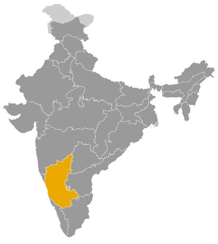
This map illustrates the maximum territory that the Nayak of Shorapur Dynasty had reached at its height, covering the current regions of Karnataka in India. Its main purpose is to provide a visual aid to understand the geographical extent of this dynasty. However, it's important to note that the contemporary borders of these regions may not necessarily coincide with the historical territories.
The Shorapur Nayak Dynasty and Its Role in the Political and Cultural History of the Deccan
A regional principality in northern Karnataka
The Shorapur Nayak dynasty, also associated with Surapura, was a regional ruling house of northern Karnataka. Its history belongs to the political world of the Deccan, where small principalities, military households, sultanates, Maratha powers, Hyderabad and later the British competed for influence. The dynasty was connected with the Bedar or Beda Nayakas, warrior groups who established authority in a frontier zone between Karnataka and the broader Deccan.
Shorapur did not become a large kingdom comparable to Mysore, Madurai or Keladi. Its importance lay rather in its ability to maintain a local principality in a region of shifting suzerainties. From the seventeenth century to the nineteenth century, the Nayaks of Shorapur preserved a distinct political identity while adapting to the changing balance between Bijapur, the Mughals, the Nizam of Hyderabad, the Marathas and the British.
Political authority between local autonomy and external control
The dynasty is commonly traced to Gaddi Pidda Nayaka, who established Nayak authority in the Shorapur region during the seventeenth century. The rulers bore titles such as Nayaka or Nayak, and later several were also referred to as Raja. Their power was based on control of villages, forts, armed retainers, agrarian revenues and local networks of loyalty.
The political status of Shorapur was rarely absolute independence in the imperial sense. Like many small Deccan states, it functioned through negotiated autonomy. The rulers could govern locally, command troops and maintain a court, but they often had to recognise more powerful overlords. After the decline of the Bijapur Sultanate and the Mughal expansion into the Deccan, Shorapur became part of a wider political field in which survival depended on tribute, diplomacy and military usefulness.
In the eighteenth century, the Nizam of Hyderabad and the Marathas became the major powers affecting the principality. Shorapur’s rulers had to balance these pressures while preserving their hereditary authority. This made the dynasty an example of how small states survived in the Deccan through adaptation rather than conquest.
Military role in a contested frontier zone
The military role of the Shorapur Nayaks was central to their political identity. Their principality lay in a dry inland region where control of fortified places, routes and local manpower mattered greatly. The Bedar Nayakas were associated with martial traditions, and their authority depended on their capacity to defend territory, mobilise armed groups and respond to pressure from larger states.
This military character remained visible until the final phase of the dynasty. Venkatappa Nayaka IV, the last effective ruler, was placed under British supervision as a child but later became associated with the uprising of 1857. His opposition to British authority led to his capture and death in 1858. After this, Shorapur was annexed, ending the political autonomy of the dynasty. This episode gives the Nayaks of Shorapur a place in the wider history of resistance to colonial expansion.
Cultural patronage in Surapura
The cultural role of the Shorapur Nayaks was more local than imperial, but it remains significant. The court of Surapura is associated with traditions of painting, religious patronage and regional artistic production. Surpur or Surapura painting developed in a courtly environment shaped by Deccan, Karnataka and local influences. It reflects the ability of a modest principality to sustain artistic life and visual identity.
The rulers also supported temples, ritual institutions and local religious establishments. Such patronage strengthened their legitimacy among local communities and connected the court with village society, religious specialists and regional elites. In the Deccan, political authority was often expressed through visible support for shrines, festivals, buildings and sacred networks. Shorapur followed this broader pattern, even though its resources were more limited than those of larger kingdoms.
The cultural significance of the dynasty therefore lies not in monumental architecture on a large scale, but in the preservation of a regional court culture. Surapura became a centre where local identity, warrior authority and artistic patronage were closely linked.
Economic foundations in agrarian revenue and local control
The economy of the Shorapur principality was based mainly on agrarian revenue. The rulers depended on villages, cultivated land, local taxes, grazing zones, markets and control of inland communications. Unlike Keladi, Shorapur did not benefit from direct access to maritime trade, and unlike Madurai, it did not control a major urban temple economy. Its resources were more modest and more closely tied to rural production.
This economic structure shaped the political limits of the dynasty. The rulers needed enough revenue to maintain troops, support their court, patronise religious institutions and pay tribute when required. Obligations to Hyderabad, pressure from Maratha authorities and later British intervention reduced the financial freedom of the principality. Its economy was therefore viable at a local level but vulnerable to external demands.
At the same time, the control of roads, local markets and defensive positions gave Shorapur practical importance. The principality formed part of the inland networks that connected northern Karnataka with the Deccan. Its economic role was regional and territorial rather than commercial on a large scale.
A small dynasty with broader historical meaning
The Shorapur Nayak dynasty occupies an important place in Indian history because it illustrates the role of small regional powers in the Deccan. It shows that Indian political history was not shaped only by empires and large kingdoms. Smaller principalities also defended territories, negotiated with stronger states, maintained courts, supported religious institutions and preserved local identities.
Its history links several major phases of South Indian and Deccan politics: the decline of Bijapur, Mughal expansion, the rise of Hyderabad, Maratha influence and British colonial consolidation. The fall of Shorapur after the events of 1857 marked the end of one of these local sovereignties. The dynasty’s legacy lies in its military resilience, its regional cultural patronage and its long effort to survive between more powerful neighbours.
The Geographic Reach of the Shorapur Nayak Dynasty in Northern Karnataka and the Deccan
A compact principality in the northern Karnataka plateau
The Shorapur Nayak dynasty, also known through the name Surapura, controlled a regional principality in the northern part of present day Karnataka. Its territory was centred on Shorapur, in the area now associated with Yadgir district, within a dry inland landscape of plateaus, rocky elevations, cultivated villages and fortified settlements. Unlike the larger Nayak kingdoms of Madurai or Keladi, Shorapur did not rule an extensive realm. Its importance came from its position in a frontier zone between Karnataka and the wider Deccan.
The dynasty is usually associated with the Bedar or Beda Nayakas, warrior chiefs who established authority over a limited but strategically placed territory. Their domain lay near routes connecting northern Karnataka with the Deccan interior. This location made Shorapur a small but relevant political actor in a region where larger powers frequently competed for tribute, military support and territorial influence.
Surapura as the territorial and political centre
The core of Shorapur power was the town and surrounding region of Surapura or Shorapur. From this centre, the Nayaks controlled villages, agricultural lands, local markets, defensive points and military retainers. Their authority depended on the ability to secure rural revenue and maintain armed followers rather than on large scale conquest.
The local geography shaped the nature of their rule. The region was not dominated by a major riverine delta or rich coastal trade, but by inland agriculture, dry cultivation, pastoral resources and communications across the Deccan plateau. The rulers therefore needed to protect settlements, manage local chiefs and preserve access to routes and revenue sources. Their territorial power was practical, military and fiscal.
Boundaries shaped by influence rather than fixed frontiers
The geographic extension of Shorapur cannot be understood as a state with sharply defined modern borders. Like many Deccan principalities, it functioned through a combination of direct control, tribute relations, village rights, military obligations and negotiated authority. The Nayaks had a stronger hold over the core around Shorapur, while their influence in surrounding areas varied according to military strength and political circumstances.
This flexibility was typical of smaller powers in the Deccan. A village, fort or revenue district could shift allegiance depending on the pressure exerted by stronger neighbours. Shorapur’s territory therefore expanded or contracted not through the creation of a large empire, but through local negotiation, warfare, tribute arrangements and the ability of its rulers to maintain armed authority.
Relations with Bijapur and the Mughal Deccan
During the seventeenth century, Shorapur lay within the broader sphere affected by the Bijapur Sultanate. Bijapur was one of the major powers of the Deccan, and smaller chiefs in the region had to adjust to its influence. The Nayaks of Shorapur preserved local power, but their autonomy existed within a political environment shaped by larger sultanate authority.
After the decline of Bijapur and the Mughal expansion into the Deccan, the balance changed again. Shorapur was not strong enough to resist imperial transformations directly, but it could survive by adapting to new suzerainties. This pattern shows the importance of geography: the principality was small enough to be overlooked at times, but strategically placed enough to matter in local military and fiscal arrangements.
A sensitive position between Hyderabad and the Marathas
In the eighteenth century, the geographic position of Shorapur became especially significant because of the rivalry between the Nizam of Hyderabad and the Marathas. The principality lay in a zone where both powers sought influence. Hyderabad claimed authority over many Deccan territories, while the Marathas expanded through tribute demands, raids and political pressure.
For the Nayaks of Shorapur, this meant that territorial control could not be separated from diplomacy. They had to preserve their local domain while avoiding complete absorption by stronger states. At different moments, Shorapur functioned as a tributary or semi autonomous principality. Its rulers governed locally, but their freedom was limited by obligations to more powerful neighbours.
This position also influenced relations with other regional chiefs. Shorapur had to maintain alliances, manage rivalries and prevent local fragmentation. Its territory was a buffer and a prize: small in size, but useful in the contest between Deccan powers.
Local relations within northern Karnataka
The Shorapur Nayaks also interacted with neighbouring chiefs and landed powers of northern Karnataka. These relationships were shaped by control of forts, grazing lands, agricultural villages, water resources and routes. In this environment, dynastic relations were not based only on formal treaties. They also involved kinship ties, local rivalries, military service and competition for revenue.
Because Shorapur’s territory was limited, its rulers depended on maintaining authority over nearby communities and subordinate chiefs. A loss of local loyalty could weaken the state more quickly than in a larger kingdom. This gave the principality a political structure that was both resilient and fragile: resilient because it was rooted in local networks, fragile because those networks could be disrupted by stronger outside powers.
British intervention and the end of territorial autonomy
By the nineteenth century, British influence transformed the political geography of Shorapur. The principality was connected to the wider Hyderabad sphere, where British Residents and political agents increasingly intervened in succession disputes, administration and security. The accession of Venkatappa Nayaka IV as a child placed Shorapur under direct political supervision, reducing the effective autonomy of the dynasty.
The final crisis came during the uprising of 1857. Venkatappa Nayaka IV became associated with resistance to British authority, and his capture and death in 1858 ended the independent status of Shorapur. The annexation of the state marked the disappearance of the principality as a territorial power. Its lands were absorbed into a new colonial administrative order.
A small territory with strategic historical significance
The geographic extension of the Shorapur Nayak dynasty was modest compared with the great kingdoms of South India. Its power centred on Surapura in northern Karnataka and extended over a compact inland zone of villages, forts, routes and revenue rights. Yet its location between the Deccan, Karnataka, Hyderabad, Maratha influence and British expansion gave it historical importance.
The dynasty’s relations with neighbouring powers were determined by this geography. Shorapur survived by balancing local military authority with external dependence. Its history shows how a small Deccan principality could maintain identity and autonomy for generations, while remaining vulnerable to the ambitions of larger states. The territorial history of Shorapur therefore reflects the complex political landscape of northern Karnataka, where even limited regional powers played a meaningful role in the wider history of India.
The rulers of Shorapur, or Surapura, are generally described as Nayaka or Nayak, and several also bore the title Raja. The dynasty is connected with the Bedar or Beda Nayakas and with the so-called Gosala line; the succession remains imperfectly documented, especially for the intermediate reigns. The dates below are therefore indicative; from the eighteenth century onward, Shorapur often functioned as a tributary or semi-autonomous state between the Nizam of Hyderabad, the Marathas and later the British.
- Gaddi Pidda Nayaka I (c. 1636–1666) • Generally recognised as the founder of the Shorapur principality. He established the authority of the Bedar Nayakas in the Shorapur doab region.
- Pama Nayaka I (c. 1666–1687) • Successor of Pidda Nayaka I and Nayak chief of Shorapur. He is associated with the conflicts of the late Bijapur Sultanate and the first Mughal pressures.
- Pidda Nayaka II (c. 1687–1727) • Ruler of Shorapur after a period disturbed by Mughal campaigns. He is connected with the restoration of local power and the development of Surapura as a political centre.
- Pitambara Bahiri Pidda Nayaka (late 17th century–early 18th century, uncertain dating) • Raja or Nayak chief associated with religious constructions at Surapura. His exact place in the succession appears to overlap with or continue that of Pidda Nayaka II in some local traditions.
- Balasoma Nayaka (18th century) • Ruler mentioned in the traditions of Shorapur. His reign belongs to a phase in which the principality had to deal with Deccan powers and the Marathas.
- Hire Pama Nayaka (18th century) • Nayak chief of Shorapur cited in dynastic lists. The details of his reign are poorly secured.
- Devendra Venkatappa Nayaka (late 18th century or early 19th century) • Raja of Shorapur remembered in the dynastic and artistic memory of Surapura. His reign belongs to the period of increasing dependence on Hyderabad and colonial powers.
- Krishnappa Nayaka (until 1841) • Raja of Shorapur and father of Venkatappa Nayaka IV. His death triggered a succession placed under British political supervision.
- Venkatappa Nayaka IV (1841–1858, regency until 1853) • Last effective ruler of Shorapur. Crowned as a child under the guardianship of Philip Meadows Taylor, he joined the 1857 rebellion and died in captivity in 1858, after which the state was annexed.
 Links to the main sections of the site