

 Français (France)
  Nederlands (nl-NL)
 Of Hindu tradition, the Nayak of Chitradurga dynasty ruled for approximately 231 years, ± between 1568 and 1799 over all or part of South India, during the Medieval Period and the Colonial Period.
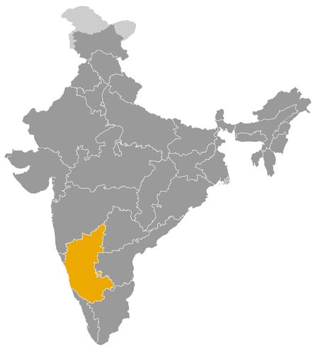
This map illustrates the maximum territory that the Nayak of Chitradurga Dynasty had reached at its height, covering the current regions of Karnataka in India. Its main purpose is to provide a visual aid to understand the geographical extent of this dynasty. However, it's important to note that the contemporary borders of these regions may not necessarily coincide with the historical territories.
The Nayak dynasty of Chitradurga in the history of Karnataka and southern India
A regional power shaped by the Vijayanagara political order
The Nayak dynasty of Chitradurga occupied a significant place in the history of Karnataka between the late sixteenth and late eighteenth centuries. Like other Nayak lineages of southern India, it emerged from the political and military system of the Vijayanagara Empire. In this context, a nayaka was a military chief, governor or territorial officer who administered land, collected revenue and supplied troops to the imperial authority.
After the decline of Vijayanagara, several Nayak chiefs transformed their delegated authority into hereditary regional power. The Nayaks of Chitradurga belonged to this process. Their authority developed around the fortified town of Chitradurga, in central Karnataka, a plateau region located between former Vijayanagara territories, Mysore, Maratha spheres of influence and the wider political world of the Deccan. Their history illustrates the transformation of a military frontier command into a fortified regional principality.
A fortified principality in central Karnataka
The political role of the Chitradurga Nayaks was closely linked to geography. Their territory was centred on a rocky hill fortress that dominated the surrounding landscape. Chitradurga Fort became the political seat, military refuge and symbolic core of the dynasty. Its walls, gateways, bastions, water systems and defensive passages reflected a form of rule adapted to a rugged environment.
The Nayaks of Chitradurga did not control a vast empire. Their power was more limited than that of Mysore, the Marathas or the larger Nayak states of Madurai and Keladi. Nevertheless, their position gave them strategic importance. They controlled routes across central Karnataka and defended an area that connected the southern Deccan, Mysore and the older Vijayanagara zone.
Their authority depended on military organisation, fortified sites, agrarian income and the cooperation of local chiefs. The dynasty had to maintain a balance between central control and regional elites. This made Chitradurga both resilient and vulnerable. The fortress could withstand pressure, but the state remained exposed to larger powers with greater military and financial resources.
Relations with Mysore, the Marathas and neighbouring powers
The Chitradurga Nayaks operated in a complex political environment. They had to negotiate with Mysore to the south, Maratha forces to the north and northwest, and various Deccan powers whose influence reached into Karnataka. Their position required flexibility. At different times they could form alliances, pay tribute, resist military pressure or take advantage of conflicts among neighbouring states.
During the eighteenth century, Mysore became the most serious threat. Under Haidar Ali, Mysore expanded aggressively into the fortified principalities of Karnataka. Chitradurga’s strategic location made it a target for incorporation into a larger and more centralised state. The defeat of Madakari Nayaka V in 1779 ended the political autonomy of the dynasty and brought Chitradurga under Mysore control.
This outcome shows that the Nayaks of Chitradurga were not isolated local chiefs. They were active participants in the wider restructuring of southern India after the decline of Vijayanagara. Their history belongs to a period in which regional powers competed for territory, revenue, military corridors and fortified centres.
Cultural impact through fortifications, temples and local memory
The cultural contribution of the Chitradurga Nayaks differs from that of the Nayaks of Madurai or Thanjavur. They are less associated with great temple cities and more with a fortified landscape. Chitradurga Fort is their most visible legacy. It combines military architecture, sacred spaces, water structures and adaptations to the natural terrain.
Within and around the fortress, temples and shrines formed part of the political and religious landscape. The Nayaks supported Hindu institutions and used religious patronage to strengthen their legitimacy. As in other Nayak states, temples were not only places of worship. They also helped organise territory, display authority and link the rulers to established regional traditions.
The dynasty also became part of local historical memory. Stories associated with the defence of Chitradurga, the last Nayak ruler and resistance to Mysore contributed to the symbolic status of the fortress. This memory gave the site a regional identity connected with courage, loyalty and the defence of autonomy.
Economic foundations based on land, water and local exchange
The economy of the Chitradurga Nayaks was based mainly on agriculture, local taxation, markets and control of inland routes. The region did not possess the maritime connections of coastal powers or the agricultural wealth of the Kaveri delta. Its resources came instead from villages, grazing lands, dry farming zones, fortified settlements and controlled movement across the plateau.
Water management was essential. In a landscape where rainfall could be uncertain, tanks, reservoirs and cisterns were critical for cultivation and defence. The water systems of the fortress were part of both military planning and everyday survival. They allowed the fort to endure sieges and supported the population living within its defensive perimeter.
The rulers had to balance military spending with the maintenance of local infrastructure and religious patronage. Their income supported garrisons, fortifications, temples and courtly activity. The economy of Chitradurga was therefore closely tied to territorial management rather than long distance maritime commerce.
A dynasty representative of regional state formation in southern India
The historical importance of the Chitradurga Nayaks lies in their role as a regional power formed from the remains of the Vijayanagara order. They did not create a large kingdom, but they organised and defended a strategic area of central Karnataka for nearly two centuries.
Their political role, fortified architecture, Hindu patronage, local economy and relations with Mysore and the Marathas make them representative of a wider process in southern Indian history. They show how military governors could become hereditary rulers, how forts could anchor regional authority and how smaller principalities could influence the balance of power between larger states.
The fall of Chitradurga in 1779 did not erase the dynasty’s significance. Its legacy remains visible in the fort, in the historical landscape of central Karnataka and in the memory of a regional polity that stood between the imperial world of Vijayanagara and the expanding states of the eighteenth century.
The geographical extent of the Nayak dynasty of Chitradurga in central Karnataka
A regional principality rooted in the Karnataka plateau
The Nayak dynasty of Chitradurga controlled a regional principality in central Karnataka from the late sixteenth century until its conquest by Mysore in 1779. Its territory was not a large empire with fixed and continuous borders. It was a fortified inland state whose influence depended on hill forts, local chiefs, agricultural villages, markets, water resources and routes crossing the plateau.
The centre of this principality was Chitradurga, a rocky hill region in present day Karnataka. Its location gave the dynasty a strategic role that was greater than the size of its territory might suggest. Chitradurga stood between the old Vijayanagara sphere, the Deccan, Mysore and the zones later affected by Maratha expansion. This position made the Nayaks of Chitradurga important intermediaries in the political geography of southern India.
Chitradurga Fort as the territorial and military core
The fortified town of Chitradurga was the political heart of the dynasty. The fort, built across granite hills and strengthened over successive reigns, served as the seat of authority, military refuge and symbol of Nayak power. Its walls, gateways, bastions, reservoirs and defensive passages were adapted to the rocky landscape.
The geography of the fort shaped the dynasty’s territorial strategy. Chitradurga was not merely a residence. It controlled movement across a wider area of central Karnataka. The surrounding territory included villages, dry farming zones, grazing lands, water tanks, small market centres and secondary fortified points. These resources were essential for supporting soldiers, maintaining the court and sustaining the population during periods of conflict.
The power of the Chitradurga Nayaks therefore depended less on broad territorial expansion than on the careful control of a defensible landscape. Their authority was strongest near Chitradurga and more variable in outlying regions, where local chiefs, military retainers and negotiated loyalties played an important role.
Areas of influence in central and eastern Karnataka
The extent of the Chitradurga principality changed over time. Under rulers such as Kasturi Rangappa Nayaka I, Bharamappa Nayaka and Madakari Nayaka V, the state exercised influence over several parts of central and eastern Karnataka. Areas associated with its authority included the region around Chitradurga, Hiriyur, Jagalur, Davanagere and routes leading toward Sira, Tumakuru, Ballari and the interior plateau.
These zones should not be understood as modern administrative boundaries. Like many premodern South Indian states, Chitradurga combined direct control, tributary relations, military occupation and local agreements. Some villages and forts were held more firmly than others. Borders could shift after war, tribute arrangements, marriage alliances, internal rebellion or intervention by neighbouring powers.
This flexible geography was typical of Nayak rule. The dynasty governed a territory that was both compact and contested. It was strong enough to remain independent for a long period, but not strong enough to dominate the wider Karnataka region.
Links with Vijayanagara and other Nayak lineages
The origins of the Chitradurga Nayaks were linked to the Vijayanagara political order. Early Nayak chiefs often emerged as military governors or feudatory leaders serving a larger imperial framework. As Vijayanagara declined, these local commanders increasingly acted as independent rulers.
This development placed Chitradurga within the broader world of the Nayak lineages of southern India. It shared an institutional background with Keladi, Madurai, Thanjavur, Gingee and other Nayak states. However, its geographical position gave it a distinct profile. Keladi was oriented toward western Karnataka and the routes to the coast, while Madurai and Thanjavur were linked to Tamil temple cities and fertile plains. Chitradurga was primarily a plateau fortress state.
Its relations with other Nayak houses were shaped by distance and regional circumstances. Chitradurga did not belong to the Tamil Nayak world, but to the Kannada speaking interior. Its closest political concerns lay with Mysore, Maratha influence and the Deccan rather than with the courts of Madurai or Thanjavur.
Pressure from Mysore, the Marathas and Deccan powers
The geographical position of Chitradurga directly influenced its relations with neighbouring dynasties. To the south, Mysore became increasingly powerful. To the north and northwest, Maratha forces intervened in Karnataka politics during the eighteenth century. The wider Deccan also remained an important field of military and diplomatic pressure.
The Nayaks of Chitradurga responded through alliances, tribute arrangements, defensive warfare and opportunistic diplomacy. Their fortress gave them considerable resistance capacity, but their state remained exposed to larger powers with greater resources. Control of Chitradurga mattered because it offered command over routes and strengthened any ruler seeking to dominate central Karnataka.
The decisive change came under Haidar Ali of Mysore. His expansion aimed to absorb the fortified principalities of the region and bring them under a more centralised military state. In 1779, Madakari Nayaka V was defeated, and Chitradurga lost its autonomy. This conquest marked the end of the dynasty as an independent territorial power.
A limited but strategically important geographical legacy
The Chitradurga Nayaks did not leave behind an empire, but their territorial role was significant. They controlled a key area of central Karnataka where fortification, topography, water management and military organisation shaped political authority.
Their geographical extent explains their historical function. They stood between older Vijayanagara traditions and the rising powers of Mysore and the Marathas. They defended a compact but valuable plateau region and influenced the balance of power in the Karnataka interior. Their legacy remains visible in Chitradurga Fort and in the historical memory of a regional state whose strength came from the strategic use of place rather than from vast territorial expansion.
The chiefs of Chitradurga are generally described as Nayakas or Paleygars. The earliest rulers were governors or feudatory chiefs linked to Vijayanagara before the rise of a more autonomous regional power. The early dates and some transitions remain approximate.
- Timmanna Nayaka of Matti (c. 1560/1588) • A local chief and governor under Vijayanagara, he is regarded as the founder of the Chitradurga Nayak line.
- Obanna Nayaka, or Madakari Nayaka I (1588/1602) • He succeeded Timmanna Nayaka and gave the lineage a more stable authority around Chitradurga.
- Kasturi Rangappa Nayaka I (1602/1652) • He consolidated Chitradurga’s power and extended its authority over neighbouring territories in central Karnataka.
- Madakari Nayaka II (1652/1674) • He continued military expansion and strengthened Chitradurga’s position against regional powers.
- Obanna Nayaka II (1674/1675) • His reign was very brief and marked by internal instability.
- Shoora Kantha Nayaka (1675/1676) • He ruled for a short period during tensions between chiefs and court factions.
- Chikkanna Nayaka (1676/1686) • He restored a degree of political continuity after several short and troubled reigns.
- Madakari Nayaka III (1686/1688) • His authority was challenged by military chiefs, weakening the stability of the state.
- Donne Rangappa Nayaka (1688/1689) • He ruled briefly before the rise of Bharamappa Nayaka from a related branch.
- Bharamappa Nayaka (1689/1721) • Often regarded as one of the greatest rulers of Chitradurga, he developed fortifications, temples and irrigation works.
- Madakari Nayaka IV (1721/1748) • He maintained regional alliances, especially with the Marathas, but faced rival Nayak chiefs.
- Kasturi Rangappa Nayaka II (1748/1754) • Supported by Maratha forces, he tried to restore several lost territories around Chitradurga.
- Madakari Nayaka V (1758/1779) • The last effective ruler of Chitradurga, he was defeated by Haidar Ali of Mysore and died in captivity.
 Links to the main sections of the site