
 Français (France)
  Nederlands (nl-NL)
 Of Hindu tradition, the Chahamana of Abhaneri dynasty ruled for approximately 300 years, ± between 700 and 1000 over all or part of North India, during the Classical Period and the Medieval Period.
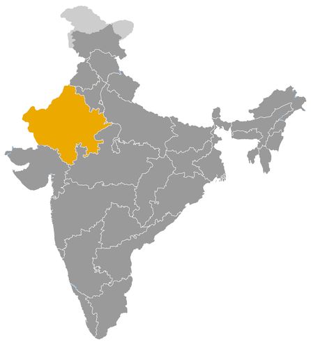
This map illustrates the maximum territory that the Chahamana of Abhaneri Dynasty had reached at its height, covering the current regions of Rajasthan in . Its main purpose is to provide a visual aid to understand the geographical extent of this dynasty. However, it's important to note that the contemporary borders of these regions may not necessarily coincide with the historical territories.
The Chahamana of Abhaneri: A Foundational Regional Dynasty in Early Medieval India
Early Formation and Emergence of Power
The Chahamana of Abhaneri represent one of the earliest identifiable branches of the wider Chauhan (Chahamana) lineage, which later became a major Rajput force in northern India. Active between the eighth and tenth centuries, this regional dynasty developed in the eastern part of present-day Rajasthan, particularly around Abhaneri, Dausa and Bandikui.
At a time when much of northern India was characterised by a mosaic of local chiefdoms, the rulers of Abhaneri began to consolidate a structured authority rooted in agricultural management, ritual patronage and the construction of monumental hydraulic works. Archaeological remains indicate that the region possessed established administrative customs and a stable social hierarchy long before the rise of the larger Chahamana centres of Ajmer and Delhi.
The emergence of Abhaneri as a regional nucleus reflects the broader political transformation of early medieval India, in which small territorial units gradually evolved into more formal political entities defined by economic control and ideological legitimacy.
Territorial Structure and Regional Influence
The kingdom of Abhaneri did not expand into a vast territorial state, but it exercised firm control over a clearly defined area in eastern Rajasthan. Its core territory included Abhaneri itself, Dausa, Bandikui and a constellation of surrounding villages that depended on the dynasty for protection, agricultural organisation and religious sponsorship.
This region formed a coherent administrative unit centred on fertile plains and interconnected trade routes. Though limited in size, the territory was strategically placed along corridors linking the Rajasthan plateau to the Ganges basin. This position enhanced the dynasty’s access to trade, facilitated contact with more powerful neighbours and reinforced the stability of its local economy.
Peripheral zones, such as parts of present-day Alwar district, show signs of occasional influence, though they were never fully integrated into the Chahamana of Abhaneri’s administrative domain. Their proximity illustrates the dynasty’s limited but meaningful regional presence within a competitive political landscape.
Relations with Neighbouring Dynasties
The geopolitical context of early medieval Rajasthan placed the Chahamana of Abhaneri in a sphere of interaction with several larger and more established dynasties.
To the north and northeast, they came into regular contact with the Gurjara-Pratihara, one of the dominant powers of early medieval India. Although the Pratihara exercised wider imperial authority, the rulers of Abhaneri maintained a degree of autonomy through local alliances, tributary arrangements or shared economic interests.
To the west, the emerging Chahamana centre of Shakambhari (Ajmer) increasingly asserted its influence. Over the course of the ninth and tenth centuries, the Shakambhari branch expanded its authority and gradually absorbed several smaller Chahamana lineages, including Abhaneri. This process was not necessarily the result of direct conflict; rather, it reflects the consolidation of regional power through kinship ties, internal hierarchy and the natural tendency of smaller principalities to align with stronger Rajput houses for protection and legitimacy.
Further south and west, interactions with other regional powers such as the Paramara were indirect but shaped economic and military strategies. In this environment, the Chahamana of Abhaneri operated as a stabilising force within a transitional phase of Rajasthan’s political structure.
Cultural Contributions and Architectural Legacy
The cultural imprint of the Chahamana of Abhaneri is particularly visible in their architectural and religious patronage. The construction of Chand Baori, one of the deepest and most technically accomplished stepwells of India, stands as the most striking example of their legacy. Its monumental design demonstrates a sophisticated understanding of water management, engineering and ritual symbolism.
The Harshat Mata temple, dedicated to a local goddess associated with joy, prosperity and the agrarian cycle, provides further evidence of the dynasty’s role in shaping regional religious identity. The sculptural motifs, iconography and layout of the temple reflect a fusion of local artistic traditions and styles circulating across northern India at the time.
Through these monuments, the Chahamana of Abhaneri helped define an architectural vocabulary that influenced later Rajput and Hindu constructions. Their cultural role extended beyond architecture, shaping landscape organisation, ritual practices and the political symbolism associated with kingship and community welfare.
Economic Foundations and Trade Networks
The economic strength of the Abhaneri dynasty relied on its adept management of water resources, agricultural lands and trade routes. Stepwells and reservoirs supported stable agricultural production in a semi-arid region, allowing the dynasty to maintain food security and ensure predictable revenue flows.
Trade routes passing through the region connected Delhi and the Ganges plain with western Rajasthan, facilitating exchanges of grain, textiles, stone and metal goods. Markets that developed around these routes strengthened the local economy and contributed to the rise of administrative centres that later played a role in the Chauhan expansion under Shakambhari.
The combination of agricultural stability and commercial activity enabled the Chahamana of Abhaneri to sustain a functional local state and support cultural projects that enhanced their prestige.
Decline, Integration and Historical Significance
By the late tenth century, the political ascendancy of the Shakambhari branch overshadowed the Abhaneri lineage. The gradual integration of Abhaneri into the expanding kingdom of Ajmer reflects both internal realignments and broader shifts in regional power.
While the dynasty disappeared as an independent entity, its contributions persisted. The hydraulic systems, religious complexes and territorial organisation it developed continued to shape the region under later Chauhan rulers, and the memory of these early foundations played a role in the construction of Rajput identity during subsequent centuries.
The Chahamana of Abhaneri thus occupy a key position in the evolution of early medieval Indian politics. Their legacy lies not in territorial conquest but in their role as one of the initial centres that nurtured the administrative, cultural and economic models later adopted by larger Rajput kingdoms across northern India.
The Geographic Expansion of the Chahamana of Abhaneri and Their Regional Role in Early Medieval India
Emergence of a Regional Power in Eastern Rajasthan
The Chahamana of Abhaneri constitute one of the earliest branches of the broader Chauhan (Chahamana) lineage, active between the eighth and tenth centuries. Their territorial development unfolded within the eastern part of present-day Rajasthan, centred around Abhaneri, Dausa and Bandikui. Unlike later Chauhan lineages that built large kingdoms, the Abhaneri branch remained a regional power, but one whose territorial coherence and administrative practices played a formative role in the early political landscape of Rajasthan.
This emerging principality controlled villages, agricultural lands and religious sites, creating a stable socio-political environment in which infrastructure development, especially hydraulic architecture, served as a key element of governance.
Core Territorial Extent and Administrative Structure
The geographic expansion of the Abhaneri branch remained limited to the confines of the Rajasthan region, with no evidence of control extending into neighbouring modern states. Their core territory corresponded to the area around Abhaneri itself, including Dausa and Bandikui, which formed the nucleus of their political authority.
This zone represented a compact but well-organised administrative unit, supported by irrigation systems and agricultural production that allowed the dynasty to maintain autonomy despite the presence of larger regional powers. The network of villages around Abhaneri depended on the dynasty for protection, allocation of land rights and oversight of religious institutions.
Peripheral influence extended toward the present-day districts of Jaipur and Alwar. Localities such as Bassi, Lalsot, Rajgarh and Thanagazi were not central administrative hubs but were within the sphere of interaction created by trade routes and agricultural networks. Their inclusion illustrates the modest yet structured territorial presence of the dynasty.
Strategic Location and Control of Trade Routes
The position of Abhaneri along regional trade routes played a significant role in shaping its territorial influence. Situated on routes connecting the Ganges basin with western Rajasthan, the region benefited from commercial exchanges involving grain, textiles, craft products and building materials.
This commercial activity supported the dynasty’s economy and contributed to the emergence of marketplaces that strengthened local authority. The capacity of the rulers to secure travel routes, maintain water reservoirs and mediate transactions enhanced their standing among regional communities.
The control of water resources through monumental stepwells, including the renowned Chand Baori, further reinforced their territorial cohesion. Such structures ensured stable agricultural production and attracted populations to the region, consolidating the dynasty’s administrative reach. The combination of trade and hydraulic management formed the backbone of the Chahamana of Abhaneri’s territorial identity.
Interaction with Neighbouring Dynasties
The territorial extension of the Abhaneri branch inevitably shaped its relations with neighbouring powers. To the north and northeast, they coexisted with the Gurjara-Pratihara, one of the dominant imperial forces of early medieval India. Although the Pratihara exercised wider authority, the Abhaneri rulers likely engaged in tributary or cooperative relations to maintain autonomy while benefiting from shared commercial networks.
To the west, the emerging Chahamana power of Shakambhari (Ajmer) represented both a rival and a potential ally. As the Shakambhari branch expanded during the ninth and tenth centuries, it absorbed several smaller Chahamana lineages through kinship ties, hierarchical integration and political consolidation. The Abhaneri branch likely underwent this process, becoming progressively incorporated into a larger Chauhan polity.
Other neighbouring dynasties, such as the Paramara of Malwa, exerted indirect influence on the region. Although no direct territorial overlap is recorded, the broader geopolitical environment framed the strategies of the Abhaneri rulers, who adapted their territorial administration to a landscape in which alliances and regional balances were essential for survival.
Political Significance of a Limited but Structured Territory
The geographic extension of the Chahamana of Abhaneri may have been modest compared to later Chauhan expansions, yet it had considerable historical significance. Their consolidation of a stable territorial nucleus in eastern Rajasthan provided a foundation for the political rise of the Chauhan lineage as a whole.
Their administrative practices, centred on land control, resource management and local alliances, laid the groundwork for the formation of the more powerful Shakambhari state. Abhaneri can therefore be viewed as one of the formative laboratories of Rajput polity, where early models of governance and ritual legitimacy were tested and refined.
Economic and Cultural Dimensions of Territorial Influence
The dynasty’s territorial expansion fostered economic development through agriculture and trade, while also enabling cultural and architectural innovation. The construction of stepwells and temples strengthened social cohesion and reinforced the legitimacy of the ruling family.
The Harshat Mata temple, associated with a local deity linked to prosperity and agrarian cycles, illustrates the religious dimension of territorial integration. Its architectural features reveal a dynamic cultural landscape shaped by interactions with neighbouring regions and artistic traditions.
These monuments, coupled with the organisation of agricultural lands and rural settlements, contributed to the emergence of a distinctive cultural identity that persisted long after the political decline of the Abhaneri branch.
Decline, Integration and Long-Term Legacy
By the tenth century, the expansion of the Shakambhari Chauhans overshadowed the Abhaneri lineage, leading to its gradual integration into the expanding polity centred on Ajmer. This transition reflects the broader consolidation of Rajput power structures in the region.
Although the dynasty ceased to exist as an independent entity, its territorial organisation, cultural contributions and hydraulic expertise remained integral to the regions it once governed. The legacy of the Chahamana of Abhaneri endures in the monumental architecture they commissioned and in the administrative traditions later adopted by more powerful Chauhan dynasties.
In this sense, their limited but structured territorial expansion played a foundational role in the historical development of Rajasthan and in the evolution of the wider Chauhan political order.
List of rulers
- Roi Chandra (VIIIᵉ siècle) • Stabilise les premières chefferies locales autour d’Abhaneri et initie une gestion structurée des ressources agricoles
- Dirigeants locaux anonymes (fin VIIIᵉ – début IXᵉ siècle) • Consolidation territoriale entre Dausa et Bandikui, développement des premiers réservoirs et sanctuaires ruraux
- Roi Partapa (IXᵉ siècle)* • Associé par certaines traditions locales à des travaux hydrauliques et à la structuration de villages fortifiés (attestation discutée)
- Élite locale non identifiée (IXᵉ–Xe siècle) • Construction ou extension du Chand Baori et du sanctuaire d’Harshat Mata ; intégration progressive dans la sphère politique de Shakambhari
- Derniers chefs régionaux avant l’intégration (Xe siècle) • Perte d’autonomie au profit des Chahamana de Shakambhari, absorption administrative dans la montée en puissance d’Ajmer