

 Français (France)
  Nederlands (nl-NL)
 Of Hindu tradition, the Nayak of Keladi dynasty ruled for approximately 264 years, ± between 1499 and 1763 over all or part of South India, during the Medieval Period and the Colonial Period.
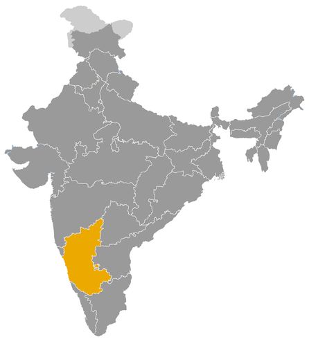
This map illustrates the maximum territory that the Nayak of Keladi Dynasty had reached at its height, covering the current regions of Karnataka in India. Its main purpose is to provide a visual aid to understand the geographical extent of this dynasty. However, it's important to note that the contemporary borders of these regions may not necessarily coincide with the historical territories.
The Keladi Nayak Dynasty and Its Role in the Political, Cultural and Economic History of South India
A regional power shaped by the decline of Vijayanagara
The Keladi Nayak dynasty was one of the most important regional powers of premodern Karnataka. Its authority developed in the Malnad region of western Karnataka from the late fifteenth century and continued until 1763, when the kingdom was conquered by Hyder Ali of Mysore. The dynasty is also associated with the names Ikkeri and Bednur, or Bidanur, after its successive capitals.
Like several other Nayak houses, the Keladi rulers first emerged within the political and military framework of the Vijayanagara Empire. They were initially local chiefs or military governors responsible for defending a strategic frontier, collecting revenue and maintaining order in a difficult terrain of forests, hills, river valleys and routes leading toward the western coast. As Vijayanagara weakened, especially after the sixteenth century, the Keladi Nayaks transformed their delegated authority into an autonomous kingdom.
A strategic kingdom between the interior and the western coast
The political importance of Keladi was closely linked to geography. The kingdom occupied a zone between the inland plateau of Karnataka, the Western Ghats and the Kanara coast. This gave the rulers control over mountain passes, agrarian valleys, forest resources and access routes to ports on the Arabian Sea.
This position made Keladi more than a small hill kingdom. It became a key intermediary between the interior of South India and maritime trade. Under rulers such as Hiriya Venkatappa Nayaka and Shivappa Nayaka, the kingdom expanded and consolidated its authority over parts of western Karnataka and the coastal belt. Shivappa Nayaka was especially important for strengthening administration, extending control over the coast and reorganising revenue collection.
The kingdom’s location also shaped its diplomacy. Keladi had to manage relations with the Wodeyars of Mysore, the chiefs of Chitradurga, the Marathas, the Portuguese and other trading groups operating along the western coast. Its survival depended on military strength, flexible alliances and the ability to control routes of economic value.
Political resistance in a fragmented South Indian landscape
After the decline of Vijayanagara, South India did not immediately pass under a single successor power. Instead, it was divided among regional kingdoms, Nayak states, sultanates, military houses and later expanding powers such as Mysore and the Marathas. In this context, Keladi became one of the most durable regional kingdoms of western South India.
The dynasty’s political role was particularly visible during the reign of Keladi Chennamma in the late seventeenth century. She resisted Mughal pressure and gave refuge to Rajaram, son of Shivaji, when he was pursued by the forces of Aurangzeb. This episode connected Keladi directly with the wider conflict between the Mughal Empire and the Marathas. It also shows that the kingdom’s importance exceeded its territorial size.
Keladi remained autonomous into the eighteenth century, but it eventually faced stronger centralising powers. Its conquest by Hyder Ali in 1763 marked the end of its independent rule and the incorporation of Bednur into the expanding state of Mysore.
Religious patronage and regional architectural identity
The cultural impact of the Keladi Nayaks was significant in western Karnataka. Their rulers supported Hindu religious institutions, temples and learned traditions. Their patronage reflected continuity with the Vijayanagara world, but it also developed a regional character adapted to the geography and society of the Malnad.
Temples associated with Keladi and Ikkeri show a mixture of Vijayanagara influence and local Karnataka forms. They include sculpted pillars, mandapas, stone sanctuaries and architectural details shaped by regional traditions. The rulers used such buildings not only as religious donations but also as visible expressions of authority, legitimacy and protection.
Ikkeri, one of the dynasty’s capitals, became an important centre of political and religious architecture. The monuments of this period demonstrate that Keladi was not merely a military state. It was also a patron of sacred art, temple construction and courtly culture. The dynasty’s cultural role lay in adapting imperial models to a western Karnataka context, where hill landscapes, forested zones and coastal connections shaped political life.
Economic strength from agriculture, forests and maritime routes
The economic foundations of the Keladi kingdom rested on land revenue, forest resources and access to trade routes. The Malnad region provided agricultural income from valleys and cultivated settlements, while forests supplied valuable products. Revenue from villages, taxes and controlled routes financed the army, administration, temples and fortifications.
The kingdom’s access to the Kanara coast gave it a broader economic role. Coastal trade connected the region with merchants from western India, the Arabian Sea world and European trading powers. Pepper, rice, timber, textiles and other goods moved through routes linking the interior to the ports. Control of these routes gave the Keladi rulers leverage over both inland producers and maritime traders.
The Portuguese presence on the western coast made diplomacy and commercial negotiation especially important. The Keladi Nayaks were not a maritime empire, but they controlled the hinterland that made coastal trade possible. This gave them economic importance beyond their immediate agrarian base.
A major regional dynasty of premodern Karnataka
The Keladi Nayak dynasty was not a pan Indian empire, but it was one of the most important regional powers in South Indian history after Vijayanagara. Its rulers transformed a provincial military position into a durable kingdom that controlled strategic routes, supported religious institutions, shaped regional architecture and participated in coastal commerce.
Its historical role lies in its capacity to link several worlds: the Vijayanagara imperial legacy, the hill country of the Malnad, the Kanara coast, the politics of Mysore, Maratha resistance and maritime trade. The dynasty’s legacy remains visible in the monuments of Keladi, Ikkeri and Bednur, and in the political memory of western Karnataka as a kingdom that combined military resilience, cultural patronage and economic adaptability.
The Geographic Expansion of the Keladi Nayak Dynasty between the Malnad, Kanara Coast and Southern Deccan
A regional kingdom rooted in western Karnataka
The Keladi Nayak dynasty developed in western Karnataka, in a region where hills, forests, river valleys and mountain routes shaped political power. Its original centre was Keladi, in the Malnad zone, before the capital shifted to Ikkeri and later to Bednur, also known as Bidanur. This movement of capitals reflects the gradual transformation of a local chiefship into a wider regional kingdom.
The dynasty first emerged within the political order of the Vijayanagara Empire. The early Keladi chiefs acted as military and administrative agents responsible for defending the western margins of imperial authority. Their original domain was not a fixed kingdom with modern borders, but a zone of command based on forts, villages, revenue rights and military obligations. As Vijayanagara weakened, especially from the sixteenth century onward, the Keladi Nayaks converted this delegated authority into an increasingly independent territorial state.
The Malnad as the defensive core of Keladi power
The heartland of the kingdom lay in the Malnad, the hilly and forested belt of the Western Ghats. This landscape gave the Keladi rulers important defensive advantages. The rugged terrain, narrow passes, dense vegetation and fortified settlements made invasion difficult and helped the dynasty survive in a period of intense regional competition.
Keladi and Ikkeri were central to this early territorial base. They controlled agricultural valleys, temple centres, forest routes and access points between the plateau and the coast. The Malnad was not as open or agriculturally rich as some plains regions, but it offered strategic depth. The rulers could defend their core territory while projecting power toward both the interior and the western seaboard.
The shift toward Ikkeri and Bednur as signs of territorial growth
The transfer of political importance from Keladi to Ikkeri and then to Bednur indicates the expanding scale of the kingdom. Ikkeri became a major centre of administration, architecture and religious patronage. Bednur later served as a more substantial capital, suited to a kingdom that had become more complex and more involved in regional politics.
These capitals were not merely symbolic. They helped the dynasty organise a territory that included hill country, agrarian settlements, fortified points and roads leading toward the coast. The geographic expansion of Keladi therefore involved both military control and administrative consolidation. The kingdom had to manage different ecological zones, from inland uplands to wetter forested regions and coastal approaches.
Expansion toward the Kanara Coast and maritime networks
One of the most important aspects of Keladi expansion was its movement toward the Kanara Coast. By controlling routes through the Western Ghats, the Nayaks gained access to ports and coastal markets on the Arabian Sea. This coastal orientation distinguished Keladi from many inland powers of Karnataka.
Under Shivappa Nayaka in the seventeenth century, the kingdom reached one of its strongest phases. His campaigns and administrative reforms strengthened Keladi’s authority over coastal and inland territories. Control of the coastal hinterland allowed the kingdom to benefit from trade in pepper, rice, timber, textiles, horses and other commodities. The western coast also connected Keladi to merchants from western India, the Arabian Sea world and European commercial powers.
This access to maritime trade had political consequences. The Portuguese and other trading groups on the coast had to negotiate with inland authorities who controlled supplies, routes and local security. The Keladi Nayaks were not a naval empire, but their influence over the coastal hinterland made them important actors in the economy of the western seaboard.
Relations with Mysore and the interior powers of Karnataka
Keladi’s geographic position shaped its relationship with Mysore. The Wodeyar state grew on the inland plateau, while Keladi controlled the Malnad and the routes toward the western coast. Their spheres were distinct but adjacent, which made both cooperation and conflict possible. Rivalry centred on frontier zones, forts, revenue lands and control of strategic passes.
As Mysore expanded, especially under Hyder Ali, the balance shifted against Keladi. The conquest of Bednur in 1763 ended the independent rule of the Keladi Nayaks. This event shows how a regional kingdom protected by difficult terrain could nevertheless be absorbed by a more centralised and militarily dynamic state.
Keladi also interacted with other interior powers such as the Nayaks of Chitradurga. These relationships were shaped by the fragmented political environment left after Vijayanagara, in which fortified regional states competed for land, tribute, military advantage and legitimacy.
The Maratha connection and the wider Deccan context
Keladi’s geographic position between the southern Deccan, the western coast and the hill country also brought it into contact with Maratha power. The kingdom became historically significant during the reign of Keladi Chennamma, who gave refuge to Rajaram, son of Shivaji, while he was pursued by Mughal forces. This episode placed Keladi within the wider struggle between the Marathas and the Mughal Empire.
The kingdom’s terrain and location made it useful as a refuge and strategic intermediary. It was not at the centre of Maratha power, but it occupied a zone through which political resistance, military movement and diplomacy could pass. This gave Keladi a role in Indian history that extended beyond its regional borders.
A compact kingdom with influence beyond its size
The geographic extension of the Keladi Nayak dynasty was not comparable to that of the great empires of India, but its territory was strategically important. The dynasty controlled a core in the Malnad, developed capitals at Keladi, Ikkeri and Bednur, extended influence toward the Kanara Coast and managed routes between the interior plateau and the Arabian Sea.
This geography determined the kingdom’s relations with neighbouring powers. Keladi stood between Vijayanagara’s legacy, Mysore’s expansion, Chitradurga’s fortified interior, Maratha movements and coastal trade networks. Its history shows how a regional dynasty, by controlling mountains, passes, forests and maritime approaches, could exercise political and economic influence far greater than its territorial size alone would suggest.
The rulers of Keladi are generally known by the title Nayaka or Nayak; the kingdom is also known as Ikkeri and later Bednur or Bidanur after its successive capitals. The presence of ruling queens, as well as variations between Nayaka, Rani and local royal forms, justifies a general formulation. The dates are indicative and may vary slightly between chronologies.
- Chaudappa Nayaka (c. 1499–1530) • Traditional founder of the Keladi line. He established local authority in the Malnad under Vijayanagara suzerainty.
- Sadashiva Nayaka (c. 1530–1566) • Important Nayak chief of the Vijayanagara Empire. He strengthened Keladi and received honours for his military service.
- Sankanna Nayaka (c. 1566–1570) • Successor of Sadashiva Nayaka. His reign was brief and continued the regional authority of Keladi.
- Chikka Sankanna Nayaka (c. 1570–1580) • Ruler of Keladi during a transitional period after the weakening of Vijayanagara. The details of his reign remain limited.
- Rama Raja Nayaka (c. 1580–1586) • Nayak ruler mentioned in the Keladi succession. His reign preceded the more durable rise of Venkatappa Nayaka.
- Hiriya Venkatappa Nayaka (c. 1586–1629) • Major ruler of Keladi. He consolidated the kingdom’s authority and strengthened its autonomy in western Karnataka.
- Virabhadra Nayaka (c. 1629–1645) • Successor of Venkatappa Nayaka. His reign maintained Keladi’s regional power before the expansion of Shivappa Nayaka.
- Shivappa Nayaka (c. 1645–1660) • One of the most famous rulers of Keladi. He expanded the kingdom, reorganised revenue and strengthened control over the Karnataka coast.
- Chikka Venkatappa Nayaka (c. 1660–1662) • Ruler with a brief reign after Shivappa Nayaka. His authority was soon followed by a new succession.
- Bhadrappa Nayaka (c. 1662–1664) • Ruler of Keladi for a short period. His reign is poorly documented.
- Somashekara Nayaka I (c. 1664–1672) • Ruler of Keladi whose reign preceded that of Queen Chennamma. His death opened a political phase dominated by the regency and effective rule of his wife.
- Keladi Chennamma (c. 1672–1697) • Queen regnant of Keladi. She defended the kingdom against Mughal pressure and granted refuge to Rajaram, son of Shivaji.
- Basavappa Nayaka I (c. 1697–1714) • Adopted successor of Chennamma. He continued the consolidation of the kingdom and supported a learned court.
- Somashekara Nayaka II (c. 1714–1739) • Ruler who faced rivalry with Chitradurga, the Marathas and other regional powers. His reign marks a period of increasing pressure on Keladi.
- Kiriya Basavappa Nayaka (c. 1739–1754) • Ruler of Keladi during the eighteenth century. He sought to preserve the kingdom’s autonomy in an unstable regional context.
- Chennabasappa Nayaka (c. 1754–1757) • Ruler with a brief reign. His authority preceded the kingdom’s final phase under Virammaji.
- Virammaji (c. 1757–1763) • Queen regnant and last effective ruler of Keladi. The kingdom was conquered by Hyder Ali of Mysore in 1763.
 Links to the main sections of the site