
 Français (France)
  Nederlands (nl-NL)
 Of Hindu tradition, (with additional Jain influence), the Chudasama dynasty ruled for approximately 598 years, ± between 875 and 1473 over all or part of West India, during the Classical Period and the Medieval Period.
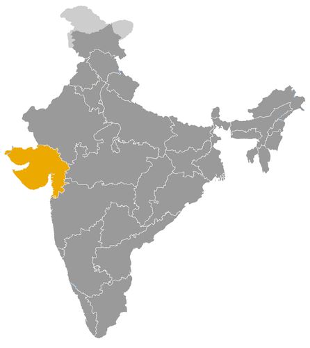
This map illustrates the maximum territory that the Chudasama Dynasty had reached at its height, covering the current regions of Gujarat in India. Its main purpose is to provide a visual aid to understand the geographical extent of this dynasty. However, it's important to note that the contemporary borders of these regions may not necessarily coincide with the historical territories.
The Chudasama Dynasty: A Lasting Regional Power in Kathiawar
Origins and Foundation
The Chudasama dynasty emerged in the Saurashtra peninsula, also known as Kathiawar, in present-day Gujarat. According to tradition, the dynasty was founded around 875 CE by Ra Chuda, whose name gave rise to the dynastic title. The Chudasamas established their capital at Junagadh, a fortified city that became the political and military center of their rule. For nearly six centuries, the dynasty endured despite external threats, particularly from the rising Muslim sultanates. Their reign came to an end in 1473 when Sultan Mahmud Begada of Gujarat captured Junagadh, marking the dynasty’s political decline.
Political and Military Context
Kathiawar’s geographical position was of great strategic importance. Located on India’s western coast, the region provided access to both inland routes and maritime trade networks across the Arabian Sea. This made it a desirable prize for competing powers but also gave the Chudasamas certain advantages in maintaining their autonomy.
Militarily, the Chudasamas were constantly challenged. They faced repeated incursions from the Delhi Sultanate and later from the Gujarat Sultanate. Their dominion was essentially regional, never expanding beyond Kathiawar, but their ability to resist external domination allowed them to preserve a distinct political identity. Their long-standing defense of Junagadh symbolized continuity in an area otherwise subject to shifting political boundaries.
Administration and Economy
The Chudasama economy rested on agriculture, cattle rearing, and above all, maritime commerce. Ports along the Kathiawar coast, particularly Diu, served as vital hubs for trade with the Arabian Peninsula and East Africa. By taxing this trade, the Chudasamas secured revenue and reinforced their regional significance.
Their administration lacked the extensive bureaucracy of larger empires but operated through local alliances and a flexible system of vassalage. This allowed them to adapt to changing circumstances while maintaining stability within their borders. Such a pragmatic approach to governance proved effective in prolonging their rule despite recurrent threats from more powerful neighbors.
Religious and Cultural Life
The Chudasamas were primarily Hindu, yet they also extended support to Jain institutions. This dual patronage reflects the pluralistic spiritual climate of Gujarat during the medieval period. Temples and religious monuments were constructed or maintained under their reign, although many have been altered or lost over time.
Junagadh became a cultural center under the Chudasamas, fostering religious traditions and local artistic expressions. Regional chronicles and oral traditions portray the dynasty as patrons of faith and defenders of cultural continuity in an era of political fragmentation. Their religious policies illustrate a model of governance that sought legitimacy through cultural and spiritual patronage.
External Relations and Conflicts
The dynasty’s external relations were defined by its interactions with neighboring Muslim powers. The Chudasamas often had to acknowledge the supremacy of the Delhi or Gujarat sultans, sometimes paying tribute or accepting nominal subordination. Yet they managed to retain significant autonomy and reassert control whenever the opportunity arose.
This balance between resistance and accommodation highlights the resilience of the dynasty. Unlike other small kingdoms that were quickly absorbed into expanding sultanates, the Chudasamas endured for centuries by relying on their fortified capital and their ability to negotiate shifting alliances. Their persistence delayed the full integration of Kathiawar into the wider Islamic political sphere until the late 15th century.
Decline and Fall
The dynasty’s decline culminated in the conquest of Junagadh by Mahmud Begada in 1473. This marked the definitive absorption of Kathiawar into the Gujarat Sultanate. The fall of Junagadh ended nearly six hundred years of Chudasama authority. While politically marginalized after this defeat, the dynasty’s memory persisted in local tradition as a symbol of resistance and continuity.
Their downfall was not the result of sudden weakness but rather the overwhelming military strength and ambition of the Gujarat Sultanate, which sought control over the lucrative trade routes of the region. The transition marked a new phase in Kathiawar’s history, one that would later attract European colonial powers such as the Portuguese.
Historical Legacy
The legacy of the Chudasamas lies less in territorial expansion than in the endurance of a regional polity under difficult circumstances. Their ability to maintain authority in Kathiawar for centuries illustrates the diversity of India’s medieval political landscape, where regional dynasties often coexisted with larger imperial structures.
Culturally, their patronage of Hindu and Jain traditions contributed to the distinctive identity of Saurashtra. Economically, their control of ports such as Diu set the stage for the region’s later importance in the Portuguese colonial network. The Chudasamas thus represent a crucial link in the historical chain that connected pre-Islamic, Islamic, and colonial phases of Gujarat’s history.
Conclusion
The Chudasama dynasty occupies a significant place in Indian history as a durable regional power in Kathiawar. Politically, they embodied resilience in the face of stronger adversaries; economically, they thrived by capitalizing on maritime trade; culturally, they reinforced the pluralistic traditions of western India. Though ultimately absorbed by the Gujarat Sultanate, their six centuries of rule highlight the importance of regional states in shaping India’s complex medieval history.
The Geographical Extension of the Chudasama Dynasty in Medieval India
Origins and Early Establishment
The Chudasama dynasty, founded around 875 CE by Ra Chuda, emerged as a regional power in the Saurashtra peninsula, also known as Kathiawar, in present-day Gujarat. This area, surrounded on three sides by the Arabian Sea and rich in natural ports, offered both opportunities and challenges. The dynasty established its capital at Junagadh, a fortified stronghold at the foot of the Girnar hills. From this strategic base, the Chudasamas gradually extended their authority over surrounding territories, balancing between inland settlements and coastal trade centers.
The Core Territory of Saurashtra
Saurashtra formed the geographical nucleus of the dynasty’s rule. The landscape of this region—comprising fertile plains, semi-arid zones, and a long coastline—allowed for a diverse economy of agriculture, pastoralism, and commerce. Junagadh, as the political capital, symbolized the dynasty’s authority and provided a defensible location against external incursions.
The Chudasamas maintained strong control over central Saurashtra, though their influence often fluctuated on the peripheries. Rival Rajput clans and, later, expanding Muslim sultanates contested their authority. Nevertheless, the Chudasamas succeeded in maintaining Saurashtra as a coherent political unit for nearly six centuries, which was in itself remarkable given the constant regional turbulence.
Control of Coastal Ports and Diu
Among the territories under Chudasama control, coastal towns were of particular significance. Chief among them was Diu, located on a small island just off the Kathiawar coast. Diu served as a vital maritime hub, connecting India with the Arabian Peninsula and East Africa. By asserting authority over Diu, the Chudasamas were able to tax maritime trade and secure a share of the wealth generated by long-distance commerce.
Other smaller ports along the Kathiawar coast were also integrated into their sphere of influence, ensuring that the dynasty was not solely dependent on agrarian resources. The possession of Diu and similar ports enhanced their economic position but also attracted external powers eager to dominate these lucrative routes. The importance of these maritime centers meant that the Chudasamas were inevitably drawn into broader geopolitical conflicts.
Relations with Neighboring Dynasties
The territorial base of the Chudasamas influenced their relationships with surrounding powers in significant ways.
• Rajput clans: As fellow Hindu rulers, neighboring Rajput groups were sometimes allies and sometimes rivals. Competition for fertile lands and strategic routes often led to shifting alliances and conflicts.
• The Delhi Sultanate: From the 13th century onward, the expansion of the Delhi Sultanate brought pressure to Kathiawar. While the Chudasamas retained local autonomy, they occasionally had to acknowledge the suzerainty of Delhi.
• The Gujarat Sultanate: The most direct threat came from the Gujarat Sultanate, established in the late 14th century. Its rulers sought to consolidate control over Saurashtra’s ports, particularly Diu, as part of their strategy to dominate regional trade. This placed the Chudasamas in a precarious position, forcing them into cycles of military resistance and diplomatic compromise.
Patterns of Expansion and Retraction
The geographical extension of the Chudasamas was not static but characterized by alternating phases of expansion and contraction. At times, their influence stretched across most of the Kathiawar peninsula, including both Junagadh and the key coastal centers. At other times, their authority was reduced to a narrower core around Junagadh, especially during periods of strong external pressure.
This dynamic reflects the fragile balance of power in western India during the medieval era. The Chudasamas’ ability to recover lost ground and maintain their dynasty for centuries demonstrates both their resilience and the strategic value of their territories.
The Role of Geography in Their Decline
Ultimately, the very importance of their territories contributed to the dynasty’s downfall. In 1473, Sultan Mahmud Begada of Gujarat launched a decisive campaign to conquer Junagadh and annex Saurashtra. The fall of the Chudasamas marked the integration of their lands into the Gujarat Sultanate, which sought full control of the coast and its ports.
The capture of Diu and other maritime centers was particularly significant, as it allowed the Gujarat Sultanate to dominate regional trade routes. This conquest also paved the way for later European interventions, especially by the Portuguese, who recognized Diu’s strategic value in controlling commerce in the Arabian Sea.
Historical Significance of Their Territory
Although the Chudasamas never built a vast empire, their geographical domain shaped the political and economic landscape of Gujarat for centuries. By holding Saurashtra and its ports, they influenced the balance of power between Hindu and Muslim dynasties in western India. Their rule demonstrates how control over relatively compact but strategically vital territories could sustain a dynasty across multiple centuries.
Their territorial legacy also underscores the continuity of Saurashtra as a contested but central region in Indian history. The Chudasamas’ presence linked earlier Hindu traditions with later Muslim and colonial phases, making their lands a key arena for the intersection of political, economic, and cultural currents.
Conclusion
The geographical extension of the Chudasama dynasty, centered on Saurashtra and the port of Diu, was the foundation of their long survival and their eventual vulnerability. Their ability to control both inland and coastal areas gave them economic strength and political relevance, while also exposing them to the ambitions of stronger neighbors. Their relations with Rajput clans, the Delhi Sultanate, and especially the Gujarat Sultanate were defined by this territorial base. Although they ultimately succumbed to Mahmud Begada’s conquest in 1473, the Chudasamas played a decisive role in shaping the regional dynamics of medieval western India and left an enduring imprint on its history.
List of rulers
- Ra Chuda (c. 875) • Founder of the dynasty, established Junagadh as the regional capital
- Ra Dyas (10th century) • Consolidated Chudasama authority in Saurashtra and strengthened local alliances
- Ra Navaghana (late 11th century) • Defended Junagadh against external incursions and stabilized regional rule
- Ra Khengar I (12th century) • Extended influence to the coast and encouraged temple construction
- Ra Mandalika I (14th century) • Resisted pressure from the Delhi Sultanate, preserved relative autonomy
- Ra Khengar II (14th century) • Temporarily lost territory to Muslim sultanates but retained Junagadh
- Ra Mandalika II (early 15th century) • Reinforced fortifications and safeguarded coastal trade
- Ra Mahipala (15th century) • Promoted agriculture and the arts, ensured local prosperity despite external threats
- Ra Mandalika III (d. 1473) • Last independent ruler, defeated by Mahmud Begada of the Gujarat Sultanate