
 Français (France)
  Nederlands (nl-NL)
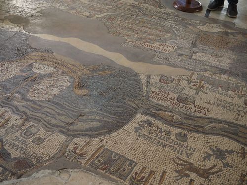
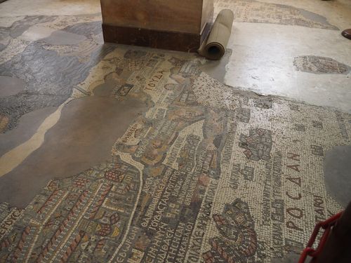
 The Madaba Map, also known as the Map of Palestine, is located in the city of Madaba, in Jordan. This large ancient mosaic is preserved inside a Byzantine church and presents a schematic depiction of the Near East as understood at the time of its creation. Cities, roads, rivers, and notable locations are shown in a structured and symbolic manner. The map is regarded as one of the most significant surviving examples of early cartography, offering valuable insight into geographic knowledge during Late Antiquity. Despite being only partially preserved, it remains an essential reference for historians and scholars.
Madaba • Map of Palestine
Madaba • Map of Palestine
Madaba • Map of Palestine
Monument profile
Map of Palestine
Monument category: Ancient mosaics
Monument family: Archaeological
Monument genre: Archaeological site
Cultural heritage: Byzantine
Geographic location: Madaba • Jordan
Construction period: 6th century AD
• Links to •
• List of videos about Madaba on this site •
Madaba, map of Holy Land • Jordan
History of the Madaba Map (Map of Palestine) in Madaba, Jordan
Political, religious, and social context of its creation
The Madaba Map, also known as the Map of Palestine, was created during the second half of the sixth century, at a time when Madaba formed part of the Byzantine province of Arabia. This period corresponded to a phase of renewed imperial confidence following administrative reforms and military consolidation along the eastern frontiers of the Byzantine Empire. Christianity had become firmly established as the state religion, and ecclesiastical institutions played a decisive role in both urban development and social organization.
The production of the map must be understood within this framework of imperial and ecclesiastical ambition. Church authorities, operating under imperial patronage, sought to reinforce doctrinal unity and religious education through monumental visual programs. The representation of Palestine and the Holy Land in mosaic form served both devotional and ideological purposes, affirming the centrality of biblical geography within Christian consciousness. By embedding a cartographic image into the floor of a church, the ecclesiastical elite transformed geographical knowledge into a tangible expression of sacred order.
The map also reflects broader social dynamics. Pilgrimage to Palestine and the Holy Land had increased significantly by the sixth century, yet many believers were unable to travel. The mosaic offered a symbolic substitute, allowing worshippers to engage visually with sacred places. This function strengthened communal identity while reinforcing the authority of the Church as custodian of sacred knowledge.
Authority, patronage, and ideological intentions
Although no dedicatory inscription identifies a specific patron, the scale and complexity of the Madaba Map indicate institutional sponsorship rather than private initiative. The project likely involved collaboration between local bishops, skilled artisans, and possibly imperial administrators. Its ambition lay not only in artistic execution but in intellectual scope: the map presents a structured vision of Palestine and the eastern Mediterranean world ordered according to Christian priorities.
The emphasis on Jerusalem, depicted with exceptional detail, reflects both theological centrality and political symbolism. At a time when the Byzantine Empire faced external threats and internal theological disputes, asserting control over the sacred geography of Palestine carried ideological weight. The map projected an image of stability and continuity, embedding the Holy Land within a coherent Christian worldview governed by ecclesiastical authority.
Major historical events affecting the site
The centuries following the creation of the Madaba Map were marked by profound upheavals. The Byzantine–Sasanian wars of the early seventh century destabilized large parts of Palestine and the broader Near East, leading to destruction and demographic change. Shortly thereafter, the Islamic conquests transformed the political and administrative landscape of the region.
These events had direct consequences for the church that housed the mosaic. Structural damage, shifts in religious usage, and changes in urban priorities contributed to the gradual decline of the building. Earthquakes, a recurring phenomenon in the region, further compromised the integrity of the site. Over time, portions of the mosaic were destroyed, reused as building material, or buried beneath later constructions.
Despite these disruptions, the map was never entirely erased. Its survival, albeit fragmentary, suggests periods of abandonment rather than deliberate destruction. This accidental preservation would later prove crucial for its rediscovery.
Global context in Late Antiquity
The Madaba Map belongs to a wider phenomenon of monumental Christian art that characterized Late Antiquity. Across the Byzantine world, large-scale mosaics adorned churches in cities such as Constantinople, Ravenna, and Thessaloniki. These programs emphasized visual instruction, symbolic hierarchy, and theological clarity.
What distinguishes the Madaba Map is its explicit cartographic function. While symbolic representations of cities and landscapes were common in Byzantine art, a comprehensive geographic depiction of Palestine integrated into an architectural setting remains rare. The map reflects the synthesis of classical geographic traditions with Christian interpretive frameworks, demonstrating how inherited knowledge was adapted to serve new ideological goals.
In this sense, the Madaba Map represents a convergence of artistic, intellectual, and religious currents shaping the late antique Mediterranean world.
Transformation, decline, and rediscovery
Following centuries of neglect, Madaba experienced a revival during the Ottoman period, particularly in the nineteenth century, when Christian communities resettled the area. During the construction of a new church on ancient foundations, the mosaic was rediscovered in 1896. This event coincided with growing European interest in biblical archaeology and the historical geography of Palestine and the Holy Land.
The discovery attracted scholars who recognized the map’s exceptional value. Early documentation, though imperfect, preserved crucial information about sections later lost. Subsequent restorations aimed to stabilize the surviving fragments, though methods reflected the conservation standards of their time and sometimes altered original features.
Urban development in Madaba continued to reshape the surroundings, integrating the site into a modern townscape while altering its historical context.
Modern role and cultural significance
Today, the Madaba Map, or Map of Palestine, holds a central place in the cultural identity of the city and the broader national heritage of Jordan. It is regarded as a key testimony to the region’s Christian past and to historical conceptions of Palestine in Late Antiquity. The map serves educational, scholarly, and touristic functions, attracting visitors from diverse backgrounds.
Although no longer embedded within an active liturgical context, the mosaic retains symbolic importance. It embodies continuity across religious and political transformations and contributes to narratives emphasizing Jordan’s historical pluralism and cultural depth.
Conservation status and contemporary challenges
The preservation of the Madaba Map presents ongoing challenges. Environmental factors such as humidity, temperature fluctuations, and seismic risk affect the stability of the materials. Tourism, while economically beneficial, introduces additional pressures related to foot traffic and microclimatic changes.
Conservation efforts focus on preventive measures, structural stabilization, and controlled access. Although the map does not possess individual World Heritage status, its international scholarly recognition imposes high standards of care. Long-term preservation depends on balancing public access with rigorous conservation strategies.
Architecture of the Madaba Map (Map of Palestine) in Madaba, Jordan
Architectural concept and integration within the church
The Map of Palestine in Madaba is not an independent architectural structure but an integral component of a Byzantine ecclesiastical building. Conceived as a monumental mosaic floor, it was designed to function within the spatial logic of a church interior. Its architectural role was therefore inseparable from circulation, orientation, and liturgical use. The map was embedded in the pavement of the nave, aligned with the longitudinal axis of the building, ensuring that its principal elements were legible from key viewpoints, particularly from the entrance and along the central processional route.
This integration required precise planning. The mosaic had to accommodate structural constraints such as column bases, wall alignments, and thresholds, while remaining visually coherent. Its placement demonstrates a deliberate architectural strategy in which decoration, movement, and symbolic meaning were unified within a single spatial composition.
Construction techniques and technological expertise
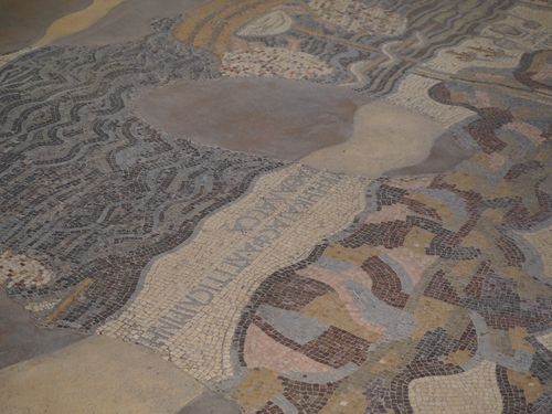
The execution of the Map of Palestine reflects advanced technological knowledge characteristic of sixth-century Byzantine mosaic production. The floor was constructed using a multilayered system designed to ensure durability under constant foot traffic. A compacted foundation layer was overlaid with coarse mortar, followed by a finer bedding layer into which the tesserae were set. This stratified construction distributed weight evenly and minimized structural stress.
The precision of tessera placement reveals a high level of craftsmanship. Artisans employed standardized cutting techniques to produce tesserae of consistent size while allowing for subtle variations to accommodate curves, inscriptions, and complex figurative elements. The stability of surviving sections indicates careful control of mortar composition and setting times, ensuring long-term adhesion.
Materials and their architectural implications
The materials used in the mosaic were selected for both structural performance and visual effect. Limestone and other locally available stones formed the majority of the tesserae, providing durability and resistance to wear. Glass tesserae, used sparingly, introduced color accents and enhanced legibility in key areas. Occasional use of imported stone suggests targeted procurement to achieve specific chromatic results.
The mortar, based on lime rather than gypsum, offered flexibility and resilience, essential in a region subject to temperature variation and seismic activity. This material choice reflects an understanding of environmental conditions and contributes to the longevity of the pavement. The interaction between stone, glass, and mortar created a surface that was both robust and visually articulate.
Spatial organization and compositional hierarchy
Architecturally, the Map of Palestine is organized according to a clear internal hierarchy. The composition is structured around a dominant central axis, with Jerusalem occupying a disproportionately large area. This spatial emphasis corresponds to the symbolic hierarchy embedded in the architecture of the church itself, where focal points guide movement and attention.
Secondary cities, roads, and geographic features are arranged around this core, following an ordered layout that balances density and readability. The scale of individual elements was carefully calibrated to maintain clarity when viewed from standing height. This concern for legibility demonstrates that architectural considerations guided artistic decisions throughout the design process.
Artistic influences and architectural traditions
The architectural language of the Madaba mosaic draws upon both Roman and Byzantine traditions. The use of mosaic floors has clear antecedents in Roman civic and domestic architecture, where pavements often carried figurative or geometric decoration. However, the schematic representation of buildings and landscapes reflects a distinctly Byzantine aesthetic, favoring symbolic clarity over naturalistic perspective.
The depiction of architectural forms within the mosaic—city walls, gates, and colonnaded streets—mirrors contemporary architectural realities while adhering to standardized visual conventions. These conventions allowed complex spatial information to be conveyed efficiently within the constraints of a floor surface.
Relationship between light, architecture, and perception
Although the mosaic itself does not emit light, its perception was closely tied to the architectural lighting of the church. Natural light entering through windows and clerestories would have interacted with the mosaic’s surface, enhancing contrast and highlighting key features. Variations in light intensity throughout the day altered visual emphasis, reinforcing the dynamic relationship between architecture and decoration.
This interplay suggests that the architects and mosaicists anticipated how light would shape perception. The careful placement of lighter tesserae in prominent areas supports this interpretation, indicating an integrated approach to architectural design.
Structural transformations and architectural alterations
Over time, the architectural context of the Map of Palestine underwent significant change. Earthquakes, structural collapse, and rebuilding episodes altered the original layout of the church. Portions of the mosaic were cut, covered, or destroyed as new walls and pavements were introduced. These interventions disrupted the original architectural coherence but also contributed to the preservation of certain sections by burying them beneath later layers.
Modern restorations have focused on stabilizing the surviving fabric without reconstructing missing elements. This approach prioritizes structural integrity and authenticity over visual completeness, preserving the architectural evidence of successive transformations.
Dimensions, scale, and notable architectural data
Originally, the Map of Palestine covered an estimated surface exceeding twenty square meters, making it one of the largest known cartographic mosaics of Late Antiquity. The tesserae are relatively small, allowing for fine detail and precise lettering. This scale required extensive planning and coordination, suggesting the involvement of a specialized workshop capable of executing large architectural commissions.
One notable feature is the consistency of workmanship across the preserved areas, indicating centralized supervision rather than piecemeal execution. This uniformity supports the interpretation of the mosaic as a single, cohesive architectural project.
Architectural significance and conservation challenges
From an architectural perspective, the Map of Palestine represents an exceptional synthesis of spatial design, material technology, and symbolic representation. Its integration into a functional church interior distinguishes it from purely decorative mosaics and underscores its role as a structural and conceptual element of the building.
Conservation challenges are closely linked to its architectural nature. As a floor mosaic, it remains vulnerable to mechanical stress, moisture infiltration, and environmental fluctuations. Urban density around the site complicates climate control and visitor management. Ongoing preservation efforts aim to balance accessibility with protection, ensuring that the architectural integrity of the mosaic is maintained.