
 Français (France)
  Nederlands (nl-NL)
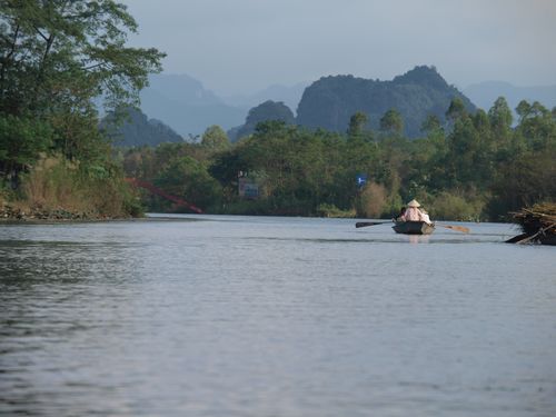
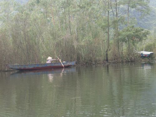
 The Yen River is a watercourse located in the Huang Tich Mountains region of Vietnam. It flows through a landscape of limestone hills, forested areas and agricultural land, forming a natural corridor that supports local communities. The river contributes to irrigation, small-scale fishing and traditional boat transport. It is also linked to cultural and tourism activities, particularly during specific seasons when visitor numbers increase. Through its environmental setting and practical functions, the Yen River constitutes an important component of the region’s natural heritage and local socio-economic life.
Huang Tich mountains • Yen river
Huang Tich mountains • Yen river
Huang Tich mountains • Yen river
Natural site profile
Yen river
Natural site category: River
Natural site family: Seas, lakes and rivers
Natural site genre: Aquatic
Geographic location: Huang Tich mountains • Vietnam
• Links to •
• List of videos about Huang Tich mountains on this site •
The Perfume Pagoda and the Yen River • Vietnam
The Yen River and the Huang Tich Mountains: Political, Cultural and Environmental Dynamics of Preservation
The Yen River, located in the Huang Tich mountain region of Vietnam, represents more than a natural watercourse shaped by geological and hydrological processes. Its preservation and valorization have evolved through successive political regimes, economic transformations, and cultural reinterpretations. The site’s importance has been shaped by shifting priorities: subsistence agriculture, state planning, postwar reconstruction, tourism development, and environmental awareness. These phases reflect both national history and broader global trends in conservation policy.
Early Management and Cultural Foundations
The earliest forms of preservation were not framed as environmental protection in the modern sense. Instead, they were embedded in agrarian management systems and cultural perceptions of landscape. In premodern Vietnam, rivers and mountain environments were essential for rice cultivation, irrigation, and transportation. Local authorities regulated water distribution and land use to maintain agricultural stability and social order.
Cultural beliefs also played a stabilizing role. Mountain and river landscapes were often associated with spiritual or symbolic meaning, which encouraged a degree of restraint in resource exploitation. While economic necessity dictated use, customary practices limited excessive alteration of the environment. This form of practical conservation emerged well before formal state policies and likely began centuries ago as part of organized agrarian society in northern Vietnam.
Globally, comparable dynamics can be observed in other traditional societies. In parts of East Asia, for example, mountain–river systems were integrated into philosophical and spiritual worldviews that indirectly supported sustainable land management. Similar patterns existed in pre-industrial Europe, where communal regulation of forests and rivers ensured long-term resource availability.
Colonial Reorganization and Shifting Priorities
The French colonial period (late nineteenth century to 1954) introduced new administrative and economic frameworks. Colonial authorities emphasized infrastructure development, agricultural intensification, and integration into global trade networks. Although large-scale industrialization did not transform every rural river basin, the reorganization of land tenure and administrative oversight altered traditional management structures.
In this context, the Yen River region experienced indirect impacts. Transportation networks improved regional connectivity, while new economic models encouraged increased agricultural productivity. However, limited industrial penetration in mountainous areas meant that certain landscapes retained a relatively intact ecological character.
This period coincided with global expansion of colonial extraction economies. Across Southeast Asia, Africa, and Latin America, similar transformations occurred, often prioritizing production over conservation. The relative preservation of some riverine landscapes was therefore less the result of deliberate protection and more a consequence of geographic constraints and limited industrial exploitation.
War, Reconstruction, and Central Planning
The mid-twentieth century conflicts in Vietnam profoundly reshaped the national landscape. Although the Huang Tich region was not necessarily among the most heavily affected battle zones, the country as a whole experienced environmental disruption, population displacement, and economic dislocation.
Following reunification in 1975, state-led reconstruction and central planning focused on agricultural recovery and food security. Rivers such as the Yen were managed within broader irrigation and rural development programs. Preservation during this phase was pragmatic: safeguarding water resources was essential for economic stabilization.
Internationally, this period overlapped with the rise of environmental consciousness. The 1972 United Nations Conference on the Human Environment in Stockholm marked a turning point in global environmental governance. While Vietnam’s immediate priorities were domestic reconstruction, global discourse on conservation gradually influenced national planning approaches in subsequent decades.
Economic Reform and Tourism Valorization
A decisive transformation began with the Đổi Mới reforms initiated in 1986. Market-oriented reforms opened Vietnam to foreign investment, tourism, and global integration. Natural landscapes acquired renewed value, not only as agricultural resources but also as cultural and economic assets.
The Yen River and the surrounding Huang Tich Mountains became increasingly integrated into regional tourism networks. Seasonal visitor flows stimulated infrastructure development and service-sector growth. Preservation motivations expanded to include economic incentives linked to tourism revenue, regional branding, and cultural identity.
This evolution parallels developments in other parts of the world. In China, karst landscapes were reinterpreted as heritage destinations and incorporated into structured conservation frameworks. In Europe, river valleys were transformed into protected landscapes balancing ecological preservation with controlled tourism. The Vietnamese approach reflects a hybrid model: state oversight combined with local economic participation.
Environmental and Social Transformations
Over centuries, the site has undergone significant environmental transformations. Agricultural expansion altered floodplains, while modifications to upstream hydrology influenced sediment deposition and seasonal water flow. In more recent decades, infrastructure improvements and increased accessibility have intensified human presence along the river corridor.
Climate variability has also played a role. The monsoon system governs hydrological cycles, and longer-term climatic fluctuations have influenced erosion patterns and biodiversity distribution. Contemporary climate change introduces new uncertainties, including altered rainfall intensity and temperature shifts that affect aquatic ecosystems.
Socially, the transition from subsistence-based agriculture to a mixed economy involving tourism and services has reshaped local livelihoods. Traditional communal management systems have partially given way to regulatory frameworks administered by local and national authorities. This shift mirrors global transitions from customary governance to formalized environmental regulation.
Comparison with Similar Sites Worldwide
The preservation trajectory of the Yen River region shares characteristics with other river–mountain systems. In Europe, protected river landscapes often evolved from agrarian utility to heritage-based conservation models supported by legal zoning and ecological monitoring. In parts of Southeast Asia, similar landscapes have been incorporated into national park systems or recognized through international heritage listings.
Unlike certain globally recognized sites, the Yen River region may not hold independent UNESCO World Heritage status. However, Vietnam’s broader experience with internationally recognized natural landscapes has influenced national conservation standards. International recognition elsewhere has demonstrated that heritage listing can enhance funding, research, and regulatory clarity, but it can also increase tourism pressure.
The Yen River’s management reflects lessons observed globally: successful conservation depends on balancing ecological protection with economic viability, community engagement, and adaptive governance.
Symbolic and Ecological Significance
Over time, the symbolic meaning of the Yen River has expanded. Initially valued for its agricultural utility, it has become a regional emblem associated with natural beauty and cultural continuity. This symbolic dimension reinforces public support for preservation measures.
Ecologically, the river functions as a biological corridor linking forested uplands and cultivated plains. Seasonal flooding supports soil fertility, while aquatic habitats sustain fish and bird populations. The interplay between natural processes and moderated human activity has historically maintained ecological resilience.
The transformation from purely utilitarian resource to symbolically valued landscape reflects broader global shifts in environmental perception. Landscapes once regarded primarily as productive assets are increasingly understood as integral to cultural identity and ecological sustainability.
Current Preservation Status and Modern Challenges
Today, the Yen River region remains relatively intact but faces mounting pressures. Tourism growth increases waste generation and demands infrastructure expansion. Urbanization in surrounding areas may introduce water quality risks, while climate change intensifies hydrological variability.
Preservation strategies emphasize integrated management: water quality monitoring, visitor regulation, environmental education, and coordination among administrative levels. The principal challenge lies in maintaining ecological integrity while supporting economic aspirations.
Globally, similar riverine landscapes confront comparable dilemmas. The experience of European river restoration projects and Asian eco-tourism management initiatives underscores the importance of long-term planning and community participation. Effective conservation requires adaptive frameworks capable of responding to environmental change and socio-economic evolution.
Conclusion
The history of preservation and valorization of the Yen River and the Huang Tich Mountains illustrates the intersection of environmental processes and human decision-making. Motivations have shifted from agricultural necessity to economic development and cultural recognition. Major historical phases—colonial restructuring, wartime reconstruction, economic reform—have each left their imprint on the landscape.
Situated within broader global trends in environmental governance and sustainable tourism, the site demonstrates how local ecosystems become embedded in international discourse. Its current state reflects both continuity and change: a river system shaped by ancient geology and modern policy alike. The future integrity of the site will depend on sustained commitment to balancing ecological preservation with responsible regional development.
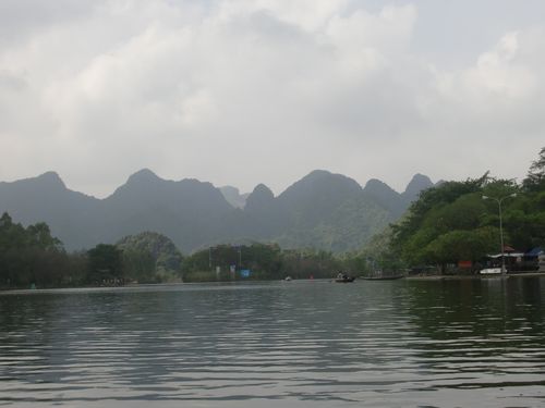
Geological Foundations and Karst Development
The mountains surrounding the Yen River are primarily composed of limestone formations deposited during the Paleozoic era, when much of what is now Southeast Asia lay beneath shallow tropical seas. Over geological time, marine organisms accumulated calcium carbonate sediments that gradually lithified into thick limestone strata. Subsequent tectonic movements associated with the convergence of regional plates uplifted these deposits, forming the elevated relief visible today.
One of the most significant processes shaping the Huang Tich landscape has been karstification. Rainwater, slightly acidified by dissolved carbon dioxide, reacts chemically with limestone, dissolving it along fractures and bedding planes. Over millions of years, this process created steep-sided hills, sinkholes, underground channels, and occasional caves. The Yen River plays an active role in this evolution. Its flow contributes to both chemical dissolution and mechanical erosion, enlarging valleys and redistributing sediments downstream.
Karst landscapes of this type are globally recognized for their scientific importance because they preserve evidence of long-term climatic variation. Fluctuations in rainfall during past glacial and interglacial periods influenced rates of dissolution and sedimentation. In this sense, the Huang Tich karst system can be understood as a natural archive of environmental change.
Topography and Hydrological Dynamics
The topography of the Yen River basin combines elevated limestone ridges with low-lying floodplains formed by alluvial deposition. This contrast creates a visually striking landscape in which narrow valleys open into broader agricultural zones. The river’s seasonal flow regime is shaped by the Southeast Asian monsoon, with pronounced differences between wet and dry periods.
During the rainy season, increased discharge leads to periodic flooding, depositing nutrient-rich sediments along the banks. This natural fertilization has historically supported agricultural productivity. In the dry season, lower water levels reveal sandbars and shallow stretches that modify habitat conditions for aquatic species.
Such hydrological variability is not merely local in origin. It reflects broader climatic systems operating across the Asian continent. Variations in monsoon intensity, influenced in part by large-scale ocean–atmosphere interactions, connect the Yen River’s behavior to global climatic processes. This interplay illustrates how a regional landscape embodies both localized environmental conditions and planetary climate patterns.
Biodiversity and Ecological Interactions
The ecological diversity of the Yen River and the Huang Tich Mountains results from the combination of limestone geology, tropical climate, and hydrological variation. Karst soils are often thin and alkaline, favoring plant species adapted to nutrient-poor conditions. Forested slopes may support mixed subtropical vegetation, including hardwood trees, shrubs, and climbing plants. In riparian zones, higher soil moisture encourages denser vegetation and greater species richness.
Aquatic habitats sustain fish species typical of tropical freshwater systems, along with amphibians and invertebrates sensitive to water quality. The river corridor also provides habitat for birdlife that depends on seasonal wetlands. The juxtaposition of upland forest and riverine environments increases ecological heterogeneity within a relatively confined area.
Although detailed biodiversity statistics specific to the Yen River basin are limited in public sources, northern Vietnamese karst regions are known to host numerous endemic plant and invertebrate species. Karst ecosystems worldwide are recognized as biodiversity hotspots due to their fragmented habitats and microclimatic variability. The Huang Tich system likely contributes to this broader pattern, even if on a regional rather than global scale.
Natural Features and Landscape Character
The defining natural feature of the site is the interaction between limestone relief and reflective river surface. Sheer rock faces rise above the water, while gentle bends in the river create shifting visual perspectives. In certain sections, the river narrows between rocky slopes, emphasizing vertical contrasts; elsewhere, it widens into calmer stretches bordered by cultivated land.
Such visual harmony has encouraged local narratives linking landscape and identity. Anecdotal accounts describe seasonal increases in visitors during festival periods, when boat traffic along the river intensifies. These patterns underscore the landscape’s aesthetic appeal as well as its ecological function.
Karst formations, including possible small caves or exposed rock pinnacles, illustrate ongoing geological processes. While not necessarily monumental in scale compared to internationally famous karst sites, they exemplify the same mechanisms of dissolution and erosion found in more widely recognized landscapes.
Local Specificity and Global Context
The Yen River site reflects a blend of local environmental conditions and global environmental drivers. Locally, limestone composition, monsoon rainfall, and traditional land use have shaped ecological dynamics. Globally, tectonic plate interactions formed the initial geological framework, and long-term climate oscillations influenced erosion rates.
Contemporary global climate change introduces additional variables. Altered precipitation patterns may affect flood frequency and sediment transport, while rising temperatures influence species distribution. Thus, the landscape stands at the intersection of deep geological time and present-day environmental transformation.
Similar karst–river systems in southern China, Laos, and parts of Europe illustrate comparable processes. In many of these regions, international recognition through conservation programs has highlighted scientific value. Even where UNESCO World Heritage status does not apply directly, regional conservation strategies often draw upon global models of protected landscape management.
Recognition and Conservation Frameworks
The Yen River and Huang Tich Mountains are situated within a national context that includes several internationally recognized natural sites. Vietnam’s participation in global environmental agreements and heritage frameworks has influenced conservation planning across the country. Although the Yen River itself may not hold independent UNESCO designation, broader awareness of karst conservation has encouraged protective measures.
In regions where UNESCO status has been granted, such recognition often leads to increased funding, scientific research, and stricter environmental regulation. It can also stimulate tourism growth, creating both opportunities and pressures. The Vietnamese experience demonstrates that even without formal listing, alignment with international conservation standards can enhance environmental stewardship.
Contemporary Environmental Challenges
Modern pressures include expanding tourism infrastructure, water quality concerns, and land-use changes in surrounding areas. Agricultural runoff and waste management are potential threats to aquatic ecosystems. Climate variability further complicates hydrological predictability.
Despite these challenges, the Yen River basin retains many of its defining natural characteristics. The geological framework remains intact, and ecological functions continue to operate within seasonal cycles. Preservation efforts increasingly emphasize sustainable tourism, environmental monitoring, and public education.
Conclusion
The Yen River and the Huang Tich Mountains exemplify how geological antiquity, ecological diversity, and hydrological dynamism converge within a single landscape. Limestone formations shaped by ancient seas, sculpted by tropical rainfall, and sustained by monsoon cycles illustrate processes fundamental to Earth’s environmental history. The site embodies both localized adaptation and global environmental interconnection.
Although not universally renowned, the landscape reflects the same scientific principles and aesthetic qualities that characterize internationally recognized karst regions. Its continued preservation depends on balancing economic development with ecological integrity, ensuring that the interplay of geology, biodiversity, and climate remains visible for future generations.