
 Français (France)
  Nederlands (nl-NL)
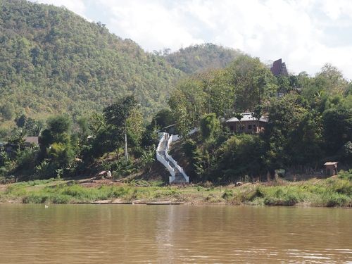
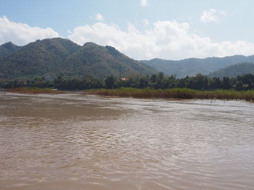
 The Mekong River in the Luang Prabang area is characterized by a wide riverbed, seasonal variations in width, and a mix of shallow zones and active channels. This section of the river is shaped by the tropical monsoon cycle, with high water levels during the wet season and more stable flow during the dry months. The surrounding landscape includes alluvial formations, terraced cultivation zones, and river access points connected to the city of Luang Prabang.
Natural site profile
Mekong near Luang Prabang
Natural site category: River
Natural site family: Seas, lakes and rivers
Natural site genre: Aquatic
Geographic location: Laos • Laos
• Links to •
• List of videos about Mekong near Muang Champassak, Mekong near Luang Prabang, Mekong from Nakasong to Li Phi Somphamit on this site •
The Mekong: A Serene River? • Laos
Human Settlement and Social Functions of the Mekong near Luang Prabang
Early habitation and local organization
The Mekong River near Luang Prabang has supported human settlement for centuries. Archaeological and oral sources indicate continuous habitation along the riverbanks since at least the Iron Age. By the 13th century, organized agricultural communities were established, using the river as both a resource and a transportation route. The consolidation of the Lan Xang kingdom in the 14th century further anchored Luang Prabang’s role as a royal center, where the river became essential for provisioning and trade until the capital was moved to Vientiane in 1560.
Settlements formed along elevated areas to avoid seasonal flooding, creating clusters of villages closely linked to religious, craft, and trade functions. These areas gradually merged into a more urbanized configuration in the 19th and 20th centuries.
Cultural and symbolic roles of the river
Beyond its economic utility, the river has played a central role in the spiritual life of the local population. Ceremonies linked to the lunar calendar—such as Pi Mai (Lao New Year)—include river-based rituals and processions. Monasteries along the banks have traditionally used the river for meditation, cleansing rituals, and transport. The river also historically served as a spatial boundary between residential areas, separating noble quarters from artisanal districts.
Floating markets and temporary trade piers were active well into the 20th century, especially at confluences such as that with the Nam Khan River. These structures facilitated seasonal exchanges of agricultural goods and textiles.
Navigation, commerce, and transport evolution
Until the 1950s, the Mekong functioned as a primary commercial artery. Timber, rice, and sugarcane were transported by wooden boats capable of carrying between two and ten tons. Luang Prabang was a regional node linking northern Laos with downstream trade points in Vientiane and Thailand.
The development of road infrastructure, particularly National Route 13, reduced the role of water transport from the 1980s onward. By 2015, it was estimated that less than 5% of local goods were moved by river, with navigation largely limited to tourism and small-scale fishing.
Changing uses in the contemporary era
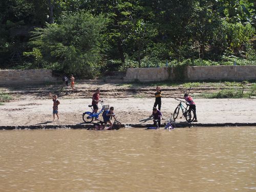
Since Luang Prabang was designated a UNESCO World Heritage Site in 1995, river use has increasingly shifted toward tourism and heritage-related activities. Daily cruises to sites such as the Pak Ou caves have seen visitor numbers exceed 80,000 annually by 2017. Concrete piers and reinforced embankments have replaced many of the informal docks formerly used by residents.
Traditional practices such as riverbank washing, ferry crossings, and communal bathing have largely disappeared from the urban sections of the river, though they continue in rural upstream and downstream locations. The river remains a key spatial and symbolic reference point within the city, shaping both the layout of public spaces and the timing of annual events.
Geographic Features and Fluvial Dynamics of the Mekong near Luang Prabang
Position within the Mekong Basin
The Mekong River near Luang Prabang occupies the transitional zone between the mountainous regions of northern Laos and the flatter plains extending toward Vientiane. Located at an elevation of approximately 290 meters above sea level, this river segment belongs to the middle basin of the Mekong system. Its width varies seasonally, ranging from 450 to 700 meters depending on water levels. Annual rainfall in the region averages 1,450 millimeters, with over 80% concentrated between May and October.
Flow discharge in this area averages 1,200 cubic meters per second during the dry season and exceeds 9,000 cubic meters per second during peak flooding. The river’s hydrology is driven by monsoon cycles, contributing to sediment redistribution and bank erosion.
Riverbed morphology and bank structure
The riverbed in this region exhibits a meandering pattern, punctuated by mid-channel sandbanks, islands, and gravel beds. The substrate consists of coarse alluvium and gravel interspersed with silty deposits. Downcutting is limited due to the shallow gradient of approximately 0.13%, promoting sediment accumulation and lateral channel shifts over time.
The right bank retains a mostly natural profile with vegetative cover, while the left bank—facing the city—has been partially reinforced. Since 2008, erosion control projects have installed gabions and concrete embankments in vulnerable zones near public infrastructure and heritage sites.
Local hydrology and contributing streams
The Nam Khan River is the main tributary joining the Mekong just east of Luang Prabang. It contributes to the seasonal discharge profile, especially during the rainy season, and plays a role in sediment transport. Secondary hydrological features include temporary creeks and seasonal wetlands used for rice farming and water collection by nearby villages.
Hydrological studies conducted between 2010 and 2015 by the French IRD (Institut de Recherche pour le Développement) estimated peak sediment transport in the rainy season at over 3,200 tons per day, reflecting the intensity of upstream erosion.
Erosion processes and physical constraints
Lateral erosion in the area is moderate but visible, particularly during peak flow periods. Annual fluctuations in river level contribute to the reactivation of secondary channels and the formation of new sandbars, which may appear and disappear from year to year.
While the main river course remains relatively stable due to underlying bedrock, localized bank collapses occur during saturation events. The river remains navigable by shallow-draft boats for most of the year, with depths ranging from 0.8 to 1.2 meters in the dry season.