
 Français (France)
  Nederlands (nl-NL)
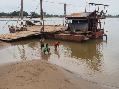
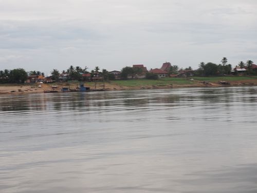
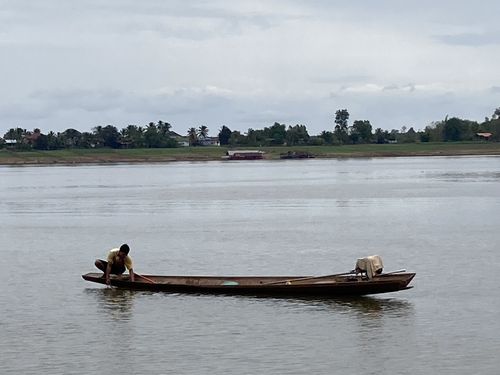
 The crossing of the Mekong at Champasak in southern Laos represents an important passage between the banks of one of Southeast Asia’s major rivers. In this area, the Mekong forms a broad waterway bordered by alluvial plains and rural landscapes that shape the organization of the surrounding territory. Ferry boats and small river vessels connect communities on both sides of the river and facilitate daily travel as well as local exchange. This crossing reflects the central role of the Mekong in regional mobility and economic life while also offering a clear view of the characteristic river landscapes of the lower Mekong basin.
Laos • Crossing the Mekong at Champassak
Laos • Crossing the Mekong at Champassak
Laos • Crossing the Mekong at Champassak
Natural site profile
Crossing the Mekong at Champassak
Natural site category: River
Natural site family: Seas, lakes and rivers
Natural site genre: Aquatic
Geographic location: Laos • Laos
• Links to •
• List of videos about Mekong near Muang Champassak, Mekong near Luang Prabang, Mekong from Nakasong to Li Phi Somphamit on this site •
The Mekong: A Serene River? • Laos
The Mekong Crossing at Champasak: Historical Dynamics, Regional Development, and Contemporary Conservation Challenges
The Mekong crossing near Champasak in southern Laos represents more than a simple point of passage across one of Southeast Asia’s major rivers. Located close to Muang Champasak, this section of the Mekong forms part of a vast river system that has shaped settlement patterns, regional trade networks, and cultural landscapes for centuries. The significance of this crossing emerged from the geographical configuration of the river, the development of communities along its banks, and the historical transformations that affected the Mekong basin as a whole. Over time, political ambitions, economic needs, and cultural practices all contributed to the recognition and gradual appreciation of the river landscape surrounding Champasak.
A strategic location within the Mekong river network
The Mekong has long functioned as one of the principal natural corridors of mainland Southeast Asia. For centuries, communities along its banks relied on the river for transportation, communication, agriculture, and fishing. In regions where the river widens and where the banks allow relatively easy access to the water, natural crossing points emerged.
Champasak developed near one of these strategic locations. The river here forms a broad but navigable channel bordered by fertile floodplains. These conditions made the area suitable for settlement and agriculture while also facilitating movement across the river.
Such crossings became essential for connecting villages, agricultural lands, and trade routes. Before the development of modern infrastructure, ferries and small boats served as the main means of linking the two riverbanks. This role established the crossing as an important node within the regional transport network.
Historical and political importance of the Champasak region
The historical significance of the crossing cannot be separated from the broader history of the Champasak region. For several centuries, Champasak served as an important political and cultural center along the Mekong. Various regional kingdoms and political entities maintained influence in the area due to its strategic position along the river.
The Mekong itself functioned as a natural route that connected different parts of mainland Southeast Asia. Political authorities often relied on river navigation to maintain administrative control and facilitate communication between territories.
The presence of reliable crossing points along the river allowed for the integration of settlements on both banks. In this context, the crossing near Champasak contributed to the cohesion of regional networks linking upland and lowland communities.
Colonial ambitions and changing perceptions of the river
During the nineteenth century, the Mekong basin attracted the attention of European colonial powers seeking to expand trade networks in Asia. French colonial authorities in Indochina explored the possibility of transforming the Mekong into a commercial route connecting Southeast Asia with southern China.
Although the river ultimately proved unsuitable for large-scale navigation because of rapids and waterfalls further downstream, colonial exploration brought increased geographic knowledge of the Mekong basin. Surveys and expeditions documented the landscapes and settlements along the river, including areas such as Champasak.
This period marked an important shift in the way the Mekong was perceived internationally. The river began to be understood not only as a regional transport corridor but also as a geographic and scientific subject of study.
Economic development and the persistence of river crossings
Throughout the twentieth century, the Mekong crossing at Champasak remained vital for local economic life. Farmers, fishermen, traders, and travelers relied on ferries to transport goods and people across the river.
Agricultural production in the surrounding floodplains benefited from the fertile soils created by centuries of sediment deposition. The river itself continued to support fishing activities that formed an important part of local livelihoods.
Even as roads gradually improved in the region, the crossing retained its practical significance. River transport remained a reliable and efficient means of movement in areas where bridges were scarce or absent.
This persistence reflects a broader pattern observed in many riverine regions of the world, where traditional crossing points continue to function alongside modern infrastructure.
Comparisons with river crossings in other parts of the world
The development of crossings along the Mekong near Champasak can be compared with similar situations along other major rivers such as the Nile, the Amazon, or the Mississippi. In many regions, ferry crossings historically served as critical connectors between communities on opposite banks.
These sites often evolved into local economic centers where markets, transport services, and settlements developed. In some cases, such crossings later became locations for bridges or other infrastructure once technological and economic conditions allowed.
The Champasak crossing therefore fits into a wider global pattern in which large rivers simultaneously connect and divide territories.
Environmental transformations over time
The landscape surrounding the Mekong near Champasak has undergone gradual transformations driven by natural processes and human activity. Seasonal flooding continues to reshape riverbanks and deposit sediments across the floodplain.
These natural dynamics have long supported agricultural productivity while also influencing settlement patterns. Communities have adapted their activities to the annual rhythms of the river, building infrastructure and cultivating crops in accordance with seasonal water levels.
More recently, broader environmental changes have begun to affect the Mekong basin. Hydropower development upstream has altered water flow patterns in some areas, raising concerns about sediment transport and ecological balance.
Current state of preservation and ecological importance
Today, the Mekong crossing at Champasak remains embedded within a largely rural landscape characterized by agricultural fields, riverbanks, and traditional settlements. The river environment retains significant ecological value due to its role in supporting freshwater biodiversity.
The Mekong basin is widely recognized as one of the richest freshwater ecosystems in the world, with an extraordinary diversity of fish species and aquatic habitats. The continued health of these ecosystems is closely tied to the natural dynamics of the river.
Although the crossing itself is not a designated international heritage site, the broader Mekong basin has become an important focus of environmental research and conservation discussions.
Contemporary challenges and future perspectives
Like many areas along the Mekong, the region near Champasak faces a series of modern challenges. Infrastructure development, increasing tourism, and hydropower projects upstream may alter the hydrological balance of the river.
Changes in sediment transport and water flow can influence riverbank stability, fish migration, and agricultural productivity. Climate change also introduces uncertainties regarding rainfall patterns and seasonal flooding.
Addressing these challenges requires coordinated management among the countries that share the Mekong basin. Sustainable river governance has become a central issue for regional development and environmental protection.
A river crossing shaped by geography and history
The Mekong crossing at Champasak illustrates how geography and human activity interact over long periods of time. What began as a natural point of passage across a wide river gradually developed into an important element of regional mobility and economic life.
Political history, colonial exploration, local trade networks, and environmental processes all contributed to shaping the landscape and its significance. Today, the crossing remains part of a broader river environment whose preservation depends on balancing economic development with ecological sustainability.
The story of this crossing therefore reflects the enduring relationship between human societies and the great rivers that structure their landscapes.
The Mekong at Champasak: River Dynamics, Biodiversity, and the Formation of a Tropical Fluvial Landscape
The section of the Mekong River near Champasak in southern Laos illustrates the complex natural processes that shape large tropical rivers. At this point in the lower Mekong basin, the river expands into a broad channel bordered by floodplains, seasonal sandbanks, and vegetated islands. These features are the result of long-term geological, hydrological, and ecological interactions that continue to transform the landscape today. The crossing area near Muang Champasak therefore represents not only a practical river passage but also an instructive natural environment where the forces of water, sediment, climate, and biodiversity combine to produce one of the characteristic landscapes of mainland Southeast Asia.
Geological processes shaping the river corridor
The present configuration of the Mekong near Champasak is closely related to the geological evolution of the lower Mekong basin. Over millions of years, sediments transported from the Tibetan Plateau and the mountainous regions of China, Laos, and Thailand have gradually accumulated in downstream areas.
These sediments, carried by seasonal floods, have created extensive alluvial plains along the riverbanks. The soils of these plains are composed mainly of silt and fine sand deposited during repeated flooding cycles. Such formations are typical of major tropical rivers and play an essential role in shaping fertile agricultural landscapes.
At the same time, variations in the riverbed structure have led to the formation of shallow channels and small islands. These islands are often formed where sediment accumulates around natural obstacles or in areas where water velocity decreases. Some remain temporary sandbanks that appear only during the dry season, while others become stable landforms covered with vegetation.
This dynamic interaction between erosion and deposition is a defining feature of large river systems and contributes to the constantly evolving morphology of the Mekong.
Hydrology and seasonal water cycles
The hydrological behavior of the Mekong is strongly influenced by the Asian monsoon system. Rainfall across the Mekong basin determines the seasonal rhythm of the river, with water levels rising dramatically during the rainy season and declining during the dry months.
Near Champasak, the difference between low-water and high-water periods can be several meters. During the wet season, the river expands across its floodplain and inundates nearby fields and wetlands. These floods deposit nutrient-rich sediments that replenish the fertility of the surrounding soils.
During the dry season, when water levels recede, sandbanks and shallow islands emerge. These areas provide temporary habitats for birds and aquatic organisms and reveal the underlying structure of the riverbed.
Such seasonal transformations illustrate the adaptability of tropical river ecosystems, where ecological processes are closely linked to periodic flooding.
Biodiversity within the Mekong ecosystem
The Mekong River is widely recognized as one of the most biologically diverse freshwater systems on Earth. Scientists have identified more than one thousand fish species within the Mekong basin, making it one of the richest aquatic ecosystems globally.
The area near Champasak contributes to this diversity through the variety of habitats created by its river channels, islands, and floodplain environments. Slow-moving waters near the riverbanks provide shelter for juvenile fish, while deeper channels serve as migration routes for larger species.
Vegetation along the banks also supports numerous birds, insects, and reptiles. The floodplain forests and wetland zones provide breeding grounds and feeding areas for many species that depend on seasonal water fluctuations.
These ecological conditions demonstrate how large river systems function as interconnected environments where aquatic and terrestrial ecosystems overlap.
Topography and the mosaic of river landscapes
One of the most notable characteristics of the Mekong near Champasak is the diversity of its river landscapes. The river’s wide channel, combined with scattered islands and sandbanks, creates a mosaic of habitats that vary in depth, current strength, and vegetation.
This landscape structure reflects the balance between the river’s powerful flow and the deposition of sediments transported from upstream regions. The resulting pattern of islands and channels is constantly reshaped by seasonal floods.
In many places along the Mekong, similar formations have developed over centuries, forming complex river archipelagos. These landscapes are particularly characteristic of the lower Mekong basin and illustrate the long-term geological evolution of the river.
Interaction between local geography and global environmental systems
The natural processes observed near Champasak are influenced by environmental factors operating far beyond the local landscape. The Mekong basin spans several countries and climatic zones, meaning that rainfall patterns, glacier melt, and regional climate systems all affect the river’s behavior.
The monsoon, which originates over the Indian Ocean and influences weather across Southeast Asia, plays a decisive role in determining water levels and sediment transport. Changes in global climate patterns may therefore alter the hydrological cycles that sustain the Mekong ecosystem.
Because of these connections, the Mekong basin is often studied as an example of how regional landscapes respond to global environmental forces.
Scientific attention and international interest
The Mekong River has attracted significant scientific attention due to its ecological richness and its importance for millions of people living along its banks. Researchers from various disciplines study the river’s hydrology, biodiversity, and sediment transport to better understand the functioning of large tropical river systems.
Although the Mekong crossing near Champasak is not itself listed as a UNESCO World Heritage Site, the broader Mekong basin has gained international recognition for its ecological significance. Conservation organizations and research institutions frequently highlight the river as a priority area for biodiversity protection and sustainable water management.
This growing international interest has contributed to greater awareness of the environmental value of the Mekong and the need to protect its ecosystems.
Environmental challenges and future conservation
Despite its natural richness, the Mekong ecosystem faces increasing environmental pressures. Hydropower development along the river and its tributaries has the potential to alter natural flow patterns and reduce sediment transport.
Such changes could affect the formation of islands and floodplains, as well as the migration routes of fish species that depend on uninterrupted river corridors.
Climate change may also influence rainfall patterns and water availability in the Mekong basin, introducing new uncertainties for both ecosystems and human communities.
Addressing these challenges requires careful management of the river and cooperation between the countries that share its waters.
A dynamic example of a tropical river system
The Mekong near Champasak illustrates the complex interplay of geological, hydrological, and biological processes that define major river systems. Its floodplains, shifting sandbanks, and rich biodiversity demonstrate how natural forces continually reshape the landscape.
As part of the vast Mekong basin, this section of the river offers valuable insight into the functioning of tropical river environments. Preserving such landscapes is essential not only for ecological reasons but also for maintaining the cultural and economic systems that depend on the river’s resources.