
 Français (France)
  Nederlands (nl-NL)
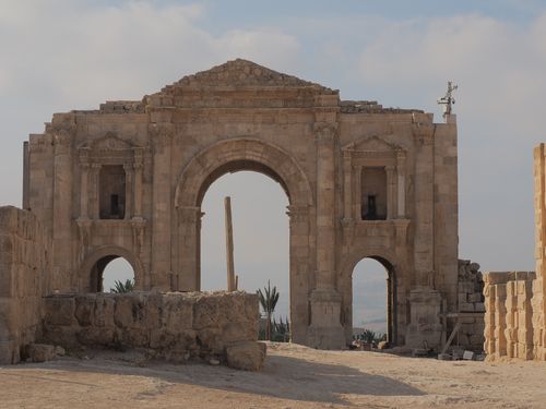
 Hadrian’s Arch in Jerash, Jordan, is a commemorative structure built to celebrate an imperial visit in the second century. Serving as the symbolic southern gateway to the ancient city, it stands today as one of Jerash’s most recognizable landmarks. Its large scale and ceremonial purpose reflect the importance of the settlement within the Roman province of Arabia. The monument is frequently visited by those seeking an overview of the region’s classical heritage and offers a meaningful starting point for understanding the city’s former urban expanse and the role it once played in regional development.

Monument profile
Hadrian's Triumphal Arch
Monument categories: Archaeological, Memorial monument
Monument families: Archaeological • Monument for cultural purposes
Monument genres: Archaeological site, Cultural or scientific
Cultural heritage: Roman antiquity
Geographic location: Jerash • Jordan
Construction period: 2nd century AD
• Links to •
• List of videos about Amman, Jerash, Umm Qais on this site •
Jordan • the Roman Jordan
Jerash, Pompeii of the East • Jordan
History of Hadrian’s Arch in Jerash
Hadrian’s Arch in Jerash stands as one of the most emblematic monuments of Roman Arabia, reflecting both the ambitions of the imperial administration and the evolution of the city of Gerasa at the beginning of the 2nd century CE. Constructed to commemorate Emperor Hadrian’s visit in 129–130 CE, the monument embodies the political aspirations, social dynamics, and urban expansion plans of a flourishing provincial city integrated into the Roman world. Its historical trajectory reveals successive layers of transformation influenced by shifting powers, environmental challenges, and renewed interest in heritage preservation.
Political and Social Context of Construction
The erection of the arch must be understood in the broader framework of Roman provincial governance. During Hadrian’s reign, public architecture was strategically used to reinforce imperial presence and encourage loyalty in frontier regions. Gerasa, as a prosperous city of the Decapolis, benefited greatly from its location on key trade routes connecting Arabia to Syria and the Mediterranean. The emperor’s visit offered an opportunity for local elites to demonstrate their allegiance and to affirm the city’s importance.
The construction of a triumphal arch outside the main urban boundaries was a deliberate political statement. Beyond honoring the emperor, it marked the projected expansion of Gerasa southward, symbolizing a period of urban optimism. The local council and civic benefactors likely funded the monument, both to elevate the city’s status within the Decapolis and to secure imperial favor. Rivalries among cities such as Philadelphia (Amman) and Gadara stimulated competition in urban embellishment, further motivating Gerasa to commission an ambitious structure.
The arch also reflects the socio-economic prosperity of the period. The region benefited from increased agricultural production, regional trade, and imperial investment in infrastructure. The populace of Gerasa—composed of Romans, Hellenized locals, and Arab populations under gradual Roman influence—viewed such monumental projects as signs of progress and stability.
Major Historical Events Affecting the Monument
Over the centuries, Hadrian’s Arch witnessed dramatic changes. Following its construction, the monument stood at the southern edge of Gerasa’s projected new district. However, the expansion plan was never fully realized. Economic shifts in the later Roman period, combined with the gradual decline of the Decapolis network, limited the growth of the city.
The 3rd and 4th centuries brought periods of instability, including regional conflicts and administrative reorganization within the Eastern Roman Empire. Although no major battles centered specifically on the arch, its surroundings suffered from fluctuating urban activity, and some decorative elements were likely damaged by natural wear rather than conflict.
During the Byzantine period, Jerash remained inhabited, but the arch lost its ceremonial role. Earthquakes—particularly those of the mid-8th century—contributed to the partial collapse of architectural elements throughout the city, including parts of the arch’s upper structure. Subsequent abandonment reduced the monument to a ruin, partially buried under centuries of soil and debris.
In the early Islamic period, the region continued to experience seismic events and shifts in settlement patterns. While Jerash never regained its Roman-level prosperity, the arch remained a recognizable landmark and, according to some accounts, a point of reference for travelers moving between the Jordan Valley and Amman.
The rediscovery of Jerash by Western explorers in the 19th century reintroduced Hadrian’s Arch to global attention. Archaeological missions in the 20th century restored stability to the monument and uncovered significant elements previously hidden, contributing to a renewed understanding of its original appearance.
Global Historical Context at the Time of Construction
The early 2nd century CE marked a phase of architectural flourishing across the Roman world. Hadrian, known for his passion for architecture, initiated projects ranging from Hadrian’s Wall in Britain to his villa at Tivoli. Across the empire, triumphal arches celebrated imperial authority, major military victories, or significant visits.
Hadrian’s tour of the eastern provinces coincided with similar urban development campaigns in Asia Minor, the Levant, and North Africa. Provincial cities, seeking imperial patronage, constructed grand monuments and reorganized public spaces following Roman urban models. Gerasa’s arch fits precisely within this wider pattern of provincial monumentalization.
Globally, similar architectural expansions occurred beyond Rome’s borders. In Parthia, urban centers displayed monumental gateways, while in Kush, significant architectural complexes demonstrated parallel expressions of political power. The arch of Hadrian thus belongs to a wider phenomenon of monumental architecture used to signal authority and urban identity in ancient civilizations.
Transformations Through the Centuries
The arch underwent significant transformations in function and appearance. Initially conceived as the ceremonial entrance of a new quarter, it later stood isolated as the expansion was halted. Over time, exposure to weather caused deterioration of the upper cornices, the attics, and decorative reliefs.
Earthquakes were a major factor in structural instability. The collapse of some portions necessitated later interventions, including partial rebuilding by archaeologists in the 20th century. The site also experienced limited reuse: some local inhabitants extracted stone blocks from structures surrounding the arch during the Ottoman period, though the arch itself remained largely intact due to its monumental size.
Modern restoration campaigns cleaned accumulated sediments, stabilized foundations, and reconstructed missing elements where evidence allowed. These initiatives aimed not at recreating the monument entirely, but at ensuring long-term preservation while retaining its historical authenticity.
Present Role and Cultural Importance
Today, Hadrian’s Arch serves as one of the principal visual identifiers of Jerash. It introduces visitors to the archaeological site and symbolizes the city’s Roman heritage. The monument is integrated into tour routes and is frequently used in educational, cultural, and promotional material about Jordan’s archaeological wealth.
Its presence reinforces a local identity connected to the broader history of the Near East. Cultural events and festivals sometimes include performances near the arch, highlighting its contemporary role as a living part of the city’s cultural landscape. The monument also contributes to regional tourism, attracting visitors to Jerash’s extensive ruins and supporting the local economy.
Conservation Status and Modern Preservation Challenges
The conservation of Hadrian’s Arch involves multiple challenges. The monument is exposed to extreme temperature variations, humidity changes, winds carrying abrasive dust, and occasional seismic activity. These conditions erode the limestone and threaten the stability of joints and decorative surfaces.
Urban development in Jerash has also posed concerns, particularly vibrations from nearby roads and traffic. Efforts by Jordanian authorities and international partners have addressed these issues by implementing buffer zones, regulating tourist access, and reinforcing vulnerable sections.
Although Jerash is not yet a UNESCO World Heritage Site, it has been proposed for inclusion, and the arch is frequently cited as a key component supporting its candidacy. Heritage specialists emphasize the importance of continuous monitoring, sustainable tourism practices, and further research to guarantee the monument’s preservation for future generations.
Architecture of Hadrian’s Arch in Jerash
Hadrian’s Arch in Jerash is one of the most striking examples of provincial Roman commemorative architecture in the Near East. Erected at the beginning of the 2nd century CE to honour Emperor Hadrian’s visit, it was conceived not merely as a symbolic gateway, but as a strong visual and urban statement at the southern approach to Gerasa. Its design combines the classic grammar of the Roman triumphal arch with adaptations to local materials, climate and topography, making it a key case study for the architecture of Roman Arabia.
Technological and architectural innovations
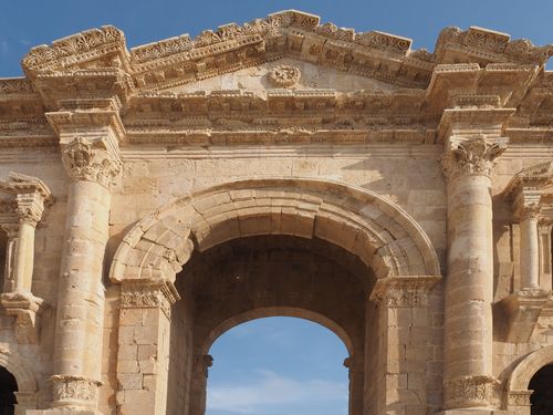
From a structural standpoint, the arch demonstrates the mature state of Roman engineering in the eastern provinces. It follows the principle of a triple-bayed triumphal arch, with a large central passage flanked by two smaller ones, but pushes the scale further than many comparable monuments in secondary cities. The builders used a carefully planned system of voussoirs for each arch, cut in local limestone and assembled with high precision so that the stability of the structure depends primarily on the geometry and weight distribution, rather than on mortar.
One of the notable innovations in the regional context is the way the massing of the piers was exaggerated to cope with local conditions. The piers are unusually thick and heavy compared with some western examples, improving resistance to wind loads and seismic activity along the Jordan Rift. The foundations extend beyond the visible footprint, distributing the load over a larger surface area to reduce settlement in the slightly sloping terrain. These technical choices reveal an awareness of the geological and climatic realities of the area and a capacity to adapt standard Roman forms to a more demanding environment.
The triple passage also reflects a sophisticated approach to circulation and urban planning. The central bay was intended for processions and formal entries, while the side bays accommodated everyday pedestrian and animal traffic. In practice, the arch was meant to function simultaneously as a ceremonial monument and as a controlled point of access on a projected new axis of urban development.
Materials and construction methods
The monument is built almost entirely of local limestone, a material that is abundant around Jerash. This stone is relatively soft when quarried, which allows precise dressing and fine carving, but it hardens on exposure, improving durability. Large ashlar blocks were quarried in nearby hills, transported to the site and dressed to standardised dimensions so they could be assembled in regular courses, a technique that reduced construction time and ensured structural coherence.
The construction uses dry masonry for the main structural elements, with joints so accurately cut that mortar could be largely omitted. This technique, common in the eastern provinces, increases the friction between blocks and allows the structure to accommodate minor ground movement without catastrophic failure. The voussoirs of the arches were laid from robust centring; once the keystones were inserted, the wooden frames could be removed, transferring the load entirely to the stone.
Metal clamps or dowels were probably used in certain places, such as cornices or more fragile decorative elements, although these are mostly lost. The ambiguity of these details is typical of many ancient stone monuments, where the non-stone components have disappeared, leaving only indirect traces in cuttings and sockets.
Influences and artistic language
In stylistic terms, Hadrian’s Arch clearly belongs to the Roman triumphal tradition, but it integrates local influences that distinguish it from Italian prototypes. The overall composition — three bays, engaged columns or pilasters framing the openings, an entablature and an attic zone — recalls canonical arches such as those in Rome or North Africa. However, the proportions in Jerash are more vertical, with a relatively tall central opening and a pronounced emphasis on the mass of the piers.
The decorative vocabulary uses Corinthian pilasters and columns with capitals carved in a manner that blends classical forms with regional preferences. The acanthus leaves are often somewhat thicker and more stylised than their counterparts in the western Mediterranean, and the profiles of mouldings and cornices are deeply cut to enhance shadow contrasts under the strong Levantine light. Geometric friezes and simple vegetal motifs complement the classical elements, reflecting the influence of Hellenistic and Nabataean traditions in the region.
Niches in the facade may have held statues or symbolic objects, contributing to the propagandistic message of the monument: the emperor, imperial virtues or personifications of the city could have been displayed here, visually anchoring the arch in a broader narrative of loyalty and civic pride.
Spatial organisation and structural logic
The spatial organisation of the arch is relatively clear and legible. The central bay, intended for the passage of vehicles and processions, is substantially wider and higher than the lateral openings. This hierarchy visually directs attention to the middle, reinforcing the idea of a main ceremonial route aligned with the planned urban extension. The side bays, narrower and slightly lower, create lateral frames and help stabilise the structure by distributing loads symmetrically.
Vertically, the monument can be read in three main registers: the base, consisting of plinths and lower courses; the main body, articulated by pilasters, imposts and archivolts; and the upper zone, originally crowned by an attic which may have carried an inscription panel and additional decorative elements. Even if parts of the attic are lost, the remaining structure indicates a careful balance between solid wall surfaces and voids created by the arches.
From a structural point of view, the arch behaves like a series of interdependent stone shells. The arches transfer vertical loads to the piers and transform part of them into horizontal thrust, which is resisted by the mass of the adjacent masonry. The thickness of the piers, the bonding of stone courses and the continuity of the entablature all contribute to the coherence of the system.
Dimensions, singular features and anecdotes
Hadrian’s Arch is impressive by provincial standards. Although exact measurements can vary slightly in modern surveys, the monument stands roughly around twenty metres high and exceeds twenty metres in width, with the central passage towering significantly above the lateral ones. The scale appears almost disproportionate when compared to the immediate surroundings, which underlines the intention to create a landmark visible from a distance.
One of the distinctive aspects of this arch is its position outside the main Roman walls, at a point that was intended to become a new monumental entrance to an expanded city. The fact that the extension project was never fully realised leaves the arch somewhat isolated, standing as a monumental prophecy of a future that did not materialise. This contributes to the particular atmosphere of the site, where the monument appears both anchored in an urban vision and detached from the final urban fabric.
International recognition and conservation challenges
Architecturally, Hadrian’s Arch is significant because it encapsulates the translation of imperial forms into a provincial context, using regional stone, craftsmen and conditions. It forms part of a broader ensemble at Jerash where colonnaded streets, theatres and temples combine to create one of the best-preserved examples of Roman urbanism in the Near East.
The main conservation issues are linked to the vulnerability of limestone to weathering, the effects of pollution and traffic in the modern environment, and the risk posed by seismic activity. Conservation efforts have focused on consolidating weakened joints, stabilising foundations and controlling visitor impact. Modern interventions are generally reversible and aim to distinguish clearly between original work and restoration, following contemporary principles of heritage conservation.
Even though Jerash is still on the tentative list for World Heritage inscription, the arch already plays a key role in the site’s international image. Its architecture, at once recognisably Roman and distinctly Levantine, contributes to the monument’s importance as a reference point for understanding how imperial architectural models were adapted, transformed and localised in the eastern provinces of the Roman Empire.