
 Français (France)
  Nederlands (nl-NL)
 Map of places or practices featured in a video published on this site
• Use the markers to explore the content •

Madhya Pradesh, India • Akhileshwar temple, Maheshwar

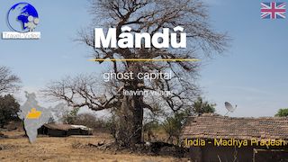
Madhya Pradesh, India • Mausoleum of Hoshang Shah, Mandu

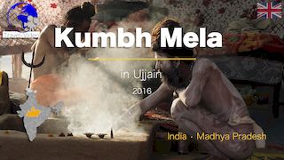
Madhya Pradesh, India • sadhus during the Kumbh Mela in Ujjain
Madhya Pradesh
History
Madhya Pradesh, located in the heart of India, has a millennia-old history marked by successive political, religious, and cultural powers. Since antiquity, the region has served as a strategic crossroads between the north and south of the subcontinent.
Among the most influential dynasties were the Maurya (4th–2nd century BCE), who integrated the region into an empire spanning most of India, followed by the Sunga and Gupta, under whom arts and sciences flourished. The Kushan also exerted influence in certain areas, promoting trade and cultural exchange. From the 9th to the 13th century, the Chandela left a remarkable architectural legacy, notably at Khajuraho.
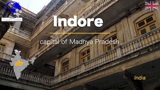
In the medieval period, the Malwa Sultanate, centred in Mandu, emerged as a regional power before falling under Mughal control. By the 18th century, the Marathas had taken the lead, with princely houses such as the Scindias in Gwalior, the Holkars in Indore, and the Bhonsles in Nagpur.
Before Independence
Due to its central position, Madhya Pradesh was a coveted territory for empires seeking to control trade routes linking the great northern plains to southern India. Ujjain, a historic capital, became a thriving religious and commercial hub, known for spreading Hindu culture and for its astronomical observatories. Centuries of alternating stability and conflict reflected the region’s strategic and economic value.
After Independence
In 1947, India’s independence led to the administrative reorganisation of territories inherited from the colonial era. Madhya Pradesh was formed in 1956 through the merger of Madhya Bharat, Vindhya Pradesh, Bhopal State, and the Central Provinces. This created one of the largest Indian states. In 2000, the creation of Chhattisgarh from its southeastern portion reduced its territory but strengthened administrative cohesion in the remaining areas. Since then, the state has pursued development focused on agriculture, emerging industries, and the promotion of its tourism assets.
Geography
Covering about 308,000 km², Madhya Pradesh is the second-largest state in India, accounting for around 9.4% of the country’s total area. It borders Rajasthan to the northwest, Uttar Pradesh to the north, Chhattisgarh to the east, Maharashtra to the south, and Gujarat to the west.
The landscape consists of plateaus and mountain ranges, mainly the Vindhya and Satpura, which frame the Narmada valley, a key geographic and cultural axis. The Tapti River is another important waterway. Dhupgarh, the highest point, rises to 1,350 metres. The diversity of landscapes includes forests, fertile plains, and arid plateaus, supporting both agriculture and biodiversity.
Economy
Madhya Pradesh ranks among India’s top ten states by gross domestic product. Its economy remains strongly agricultural, with the majority of the workforce engaged in farming. Soybeans, of which the state is one of the country’s largest
Videos
• Madhya Pradesh •

producers, along with pulses, wheat, rice, and oilseeds, are key crops.
The industrial sector is expanding, driven by pharmaceuticals, mechanical engineering, food processing, and defence manufacturing. Investments in road and rail infrastructure, as well as in energy and manufacturing, aim to strengthen competitiveness in domestic and global markets. Exports are growing steadily, diversifying beyond traditional agricultural products.
Population
With over 72 million inhabitants, Madhya Pradesh is India’s fifth most populous state. Its population is highly diverse, with significant tribal communities such as the Gond, Bhil, Baiga, and Korku, preserving distinct traditions often linked to nature and agricultural cycles.
Scheduled castes also form a substantial portion of the population. Rural areas dominate, with nearly three-quarters of residents living in the countryside, shaping social organisation and economic priorities, particularly in rural development and basic infrastructure.
Religion
Hinduism is the majority religion, followed by significant Muslim communities and smaller groups of Jains, Christians, Buddhists, and Sikhs. The state is home to major Hindu pilgrimage sites such as Amarkantak, the source of the Narmada River, and Omkareshwar, one of the twelve jyotirlingas of Shaivism. Jainism is represented by historic temples such as those at Sonagiri, while Islam has deep roots in many cities with Mughal and Sultanate heritage. Tribal religious traditions, blending animist beliefs and Hindu influences, remain vibrant in rural areas.
Cultural and Tourist Attractions
Madhya Pradesh has three UNESCO World Heritage Sites: the temples of Khajuraho, masterpieces of Chandela art; the Buddhist monuments at Sanchi, including a great stupa built under Ashoka; and the prehistoric rock shelters of Bhimbetka, decorated with paintings spanning thousands of years.
Other notable destinations include the forts and palaces of Gwalior and Orchha, the sacred city of Ujjain, a major site of the Kumbh Mela, as well as Mandu, Maheshwar, and Pachmarhi, known for their architectural or natural heritage. Bandhavgarh and Kanha National Parks attract wildlife enthusiasts, especially for Bengal tiger sightings. New projects, such as interactive museums in Ujjain, demonstrate the state’s commitment to promoting and modernising the presentation of its historical and cultural heritage.


