

 Français (France)
  Nederlands (nl-NL)
 • Use the markers to explore the content •
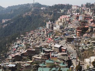
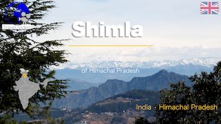
Himachal Pradesh, India • overview of Shimla
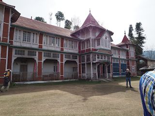
Himachal Pradesh, India • maharajah's palace, Junga Fort

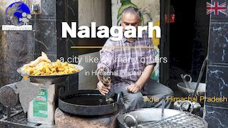
Himachal Pradesh, India • a street in Nalagarh
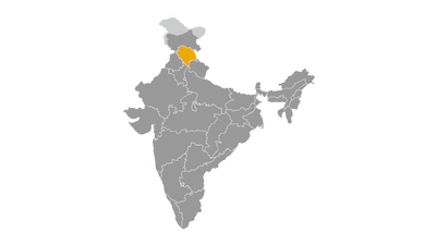
From Ancient Himalayan Kingdoms to Modern Statehood: The Historical Evolution of Himachal Pradesh
A mountainous region with ancient origins
Nestled in the western Himalayas, Himachal Pradesh possesses a history shaped by its rugged geography and strategic position between the Indian plains and the Tibetan Plateau. Towering mountain ranges, deep valleys and high-altitude passes have long influenced patterns of settlement, political organization and cultural exchange. While the region often remained outside the direct control of the great empires of northern India, it developed a rich historical identity through its numerous local kingdoms, trade networks and religious traditions.
Archaeological evidence indicates that the area has been inhabited since prehistoric times. Stone tools and other artifacts discovered in several valleys suggest the presence of hunter-gatherer communities thousands of years before the emergence of urban civilizations in the Indian subcontinent. Although the mountainous terrain prevented the development of large cities comparable to those of the Indus Valley Civilization, the region maintained contacts with neighbouring populations through seasonal migration and trade.
Ancient Indian literary sources, including the Vedas and the Mahabharata, mention several peoples inhabiting the Himalayan foothills, such as the Khasas, Kiratas, Kulindas and Trigartas. These communities gradually evolved into organized political entities adapted to the challenging mountain environment.
Early kingdoms and regional powers
Among the earliest historically documented states was the kingdom of the Kulindas, which flourished during the last centuries BCE and controlled parts of present-day Himachal Pradesh and Uttarakhand. Coins issued by Kulinda rulers demonstrate the existence of an organized administration and active commercial exchanges with neighbouring regions.
Further west, the kingdom of Trigarta emerged around the Kangra Valley. Mentioned in ancient Sanskrit literature, it became one of the most influential political centres of the western Himalayas. The fertile valleys, combined with access to important trade routes, enabled these kingdoms to prosper despite their relative isolation.
Religious developments accompanied political evolution. Hindu traditions became firmly established throughout most of the region, while Buddhism spread into the higher valleys through commercial and cultural contacts with Kashmir, Ladakh and Tibet. This dual religious influence would continue to shape Himachal Pradesh for centuries.
Influence of the great Indian empires
Although Himachal Pradesh rarely became fully integrated into the large imperial states that dominated northern India, it experienced varying degrees of political influence from successive empires.
During the reign of the Mauryan Empire in the third century BCE, the authority of Emperor Ashoka extended into parts of the Himalayan foothills. While direct administration remained limited, Buddhist missionaries contributed to the spread of Buddhism, particularly in the northern mountain districts.
Later dynasties, including the Shungas, Kushanas and Guptas, exercised influence over sections of the region without completely replacing local rulers. The difficult terrain made sustained military occupation costly, allowing many principalities to retain considerable autonomy while acknowledging imperial supremacy when politically advantageous.
By the seventh century CE, the Chinese Buddhist pilgrim Xuanzang described several independent Himalayan kingdoms, illustrating the continued political fragmentation of the area.
The rise of the Rajput principalities
Between the eighth and thirteenth centuries, numerous Rajput dynasties established or consolidated principalities that would dominate the political landscape for many centuries. States such as Chamba, Kullu, Bushahr, Mandi, Suket, Sirmaur, Bilaspur and Kangra developed distinctive political institutions, cultural traditions and ruling families.
The mountainous geography encouraged political decentralization. Each valley often formed a separate kingdom protected by natural barriers, while fortified hilltop castles overlooked strategic routes. Relations between these states alternated between alliances, dynastic marriages, commercial cooperation and military conflict.
This period also witnessed remarkable cultural achievements. Hindu temples constructed from stone and intricately carved cedar wood became architectural landmarks across the region. Patronage by local rulers encouraged the flourishing of literature, sculpture and painting. The miniature painting schools of Kangra, Guler, Chamba and Basohli would later become internationally renowned for their refined artistic style and delicate depictions of religious and courtly themes.
The Delhi Sultanates and the Mughal Empire
Beginning in the thirteenth century, the Delhi Sultanates attempted to extend their authority into the Himalayan kingdoms. However, difficult mountain terrain and the resilience of local rulers limited their success. While some principalities paid tribute or entered into temporary alliances, effective control remained confined largely to the lower foothills.
The Kangra Fort, one of northern India's most formidable hill fortresses, became a major strategic objective. Several Muslim rulers attempted unsuccessfully to capture it over the centuries.
The Mughal Empire achieved greater influence. Emperor Akbar maintained diplomatic relations with several Himalayan princes, preferring negotiated submission over prolonged military campaigns. Nevertheless, local rulers continued to enjoy substantial autonomy.
Under Emperor Jahangir, Mughal forces finally captured Kangra Fort in 1620 after a lengthy siege. Although this represented a significant symbolic victory, Mughal authority remained strongest in the lower valleys. Remote mountain regions continued to be governed by hereditary rulers who administered their territories with limited imperial interference.
Gorkha expansion, Sikh influence and British conquest
The late eighteenth century brought major political upheaval. The expanding Gorkha Kingdom of Nepal launched campaigns westward across the Himalayas, conquering several principalities in present-day Himachal Pradesh.
This expansion alarmed the British East India Company, which regarded the Himalayan frontier as strategically important. The Anglo-Nepalese War of 1814–1816 ended with the Treaty of Sugauli, forcing the Gorkhas to withdraw from much of the western Himalayas.
At approximately the same time, Maharaja Ranjit Singh's Sikh Empire expanded into parts of the region, particularly around Kangra. Following the Anglo-Sikh Wars in the mid-nineteenth century, British authority gradually replaced Sikh influence throughout the area.
The British adopted a mixed administrative approach. Some territories became directly administered districts, while numerous princely states retained internal autonomy under British paramountcy.
British colonial administration
During British rule, Himachal Pradesh acquired considerable political and strategic importance.
The hill station of Shimla became the summer capital of British India during the second half of the nineteenth century. Every year, the colonial administration moved from Calcutta and later Delhi to Shimla, transforming the town into the seasonal centre of government for the entire British Indian Empire.
Extensive infrastructure projects accompanied colonial administration. Mountain roads improved communications between valleys, while the Kalka–Shimla Railway, inaugurated in 1903, greatly enhanced access to the hill station. Today, this narrow-gauge railway is recognized as a UNESCO World Heritage Site.
Education, public administration and healthcare expanded under colonial rule, although economic life remained dominated by subsistence agriculture, pastoralism and local trade. The British also encouraged horticulture, introducing commercial apple cultivation that would later become one of the state's economic pillars.
The independence movement
Compared with the major urban centres of British India, the Himalayan princely states experienced a more gradual political awakening. Nevertheless, nationalist ideas steadily gained influence during the early twentieth century.
Praja Mandal movements emerged in several princely states, demanding constitutional reforms, greater political participation and the reduction of feudal privileges. Local activists supported the broader Indian independence movement while also seeking democratic reforms within their own principalities.
When India gained independence in 1947, the rulers of the Himalayan princely states acceded to the newly established Indian Union. This marked the beginning of a profound political transformation as centuries-old monarchies gradually gave way to democratic administration.
Formation of the modern state
On 15 April 1948, approximately thirty princely states were merged to create the Province of Himachal Pradesh. Initially administered as a Chief Commissioner's Province, it later became a Part C State under the Constitution of India.
The States Reorganisation Act of 1956 converted Himachal Pradesh into a Union Territory administered directly by the central government.
Its modern territorial configuration largely dates from 1966, when several predominantly mountainous districts were transferred from the former state of Punjab. These included Kangra, Kullu, Lahaul and Spiti, Shimla and Kinnaur, significantly enlarging the territory and population.
On 25 January 1971, Himachal Pradesh officially became the eighteenth state of the Republic of India.
Himachal Pradesh since 1971
Since achieving statehood, Himachal Pradesh has developed into one of India's most successful mountain states. Successive governments invested heavily in education, healthcare, rural development and infrastructure, resulting in comparatively high human development indicators.
Agriculture gradually diversified through commercial horticulture, especially apple production, while hydroelectric power became a major source of revenue thanks to the state's abundant mountain rivers.
Tourism expanded rapidly, with destinations such as Shimla, Manali, Dharamshala, Kullu, Spiti and Kinnaur attracting millions of visitors annually. The preservation of historic temples, Buddhist monasteries, colonial architecture and traditional villages has strengthened both cultural identity and the regional economy.
Today, Himachal Pradesh faces new challenges linked to environmental sustainability. Climate change is accelerating glacier retreat, increasing the frequency of landslides and affecting water resources. Balancing tourism, infrastructure development and environmental conservation has therefore become a central priority.
Despite these challenges, the state's long historical evolution—from isolated Himalayan kingdoms to a modern democratic state—has produced a distinctive political and cultural identity rooted in both its mountain geography and its centuries of interaction with the wider Indian subcontinent.


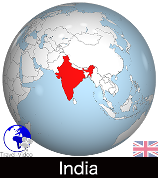
Himachal Pradesh Today: A Himalayan State Balancing Development, Nature and Cultural Heritage
A mountain state in the western Himalayas
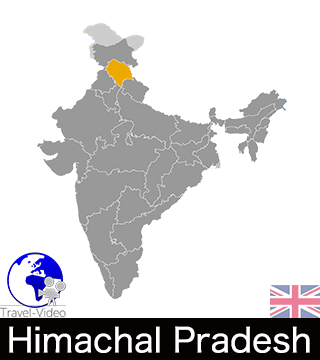
Himachal Pradesh is a state in northern India located in the western Himalayas. Covering an area of approximately 55,673 km², it is one of India's least densely populated states, with a population of more than 6.8 million according to the 2011 census. Shimla serves as the state capital, while Dharamshala hosts several important government institutions, including sessions of the Legislative Assembly.
The state shares its borders with the Union Territories of Jammu and Kashmir and Ladakh to the north, Punjab to the west, Haryana to the southwest, Uttarakhand to the southeast and the Tibet Autonomous Region of China to the east. This strategic location has historically made Himachal Pradesh an important gateway between the Indian plains and the Tibetan Plateau.
Its mountainous landscape dominates every aspect of life, influencing settlement patterns, agriculture, transportation and economic development. The state combines spectacular natural scenery with a relatively high standard of living and strong social indicators compared with many other parts of India.
Geography shaped by the Himalayas
The entire territory is characterized by mountain ranges belonging to the Himalayan system. From south to north, the landscape rises through the Shivalik Hills, the Lesser Himalayas and the Great Himalayas before reaching high-altitude regions bordering Tibet.
Altitude ranges from around 350 metres in the southern foothills to peaks exceeding 6,500 metres in the northern districts. This remarkable variation creates an exceptional diversity of landscapes, ecosystems and climatic conditions.
Several major rivers originate within or flow through the state. The Sutlej, Beas, Ravi, Chenab and Yamuna rivers are among the most important waterways, supplying water for agriculture, hydroelectric production and domestic consumption. Their valleys also provide the principal routes for roads, settlements and economic activity.
Large areas remain covered by forests of deodar cedar, pine, oak, spruce and fir, while alpine meadows and high-altitude cold deserts dominate northern districts such as Lahaul and Spiti.
Protected natural areas occupy an important place within the state's environmental policy. Great Himalayan National Park, a UNESCO World Heritage Site, is internationally recognized for its biodiversity and its populations of rare Himalayan species, including the snow leopard, Himalayan tahr and western tragopan.
Climate and environmental diversity
Himachal Pradesh experiences a wide variety of climatic conditions due to its considerable differences in altitude.
The southern districts have a subtropical climate with warm summers and relatively mild winters. Mid-altitude regions around Shimla, Kullu and Mandi enjoy a temperate mountain climate with distinct seasons, while the northern highlands experience alpine conditions characterized by long snowy winters and short cool summers.
The southwest monsoon provides most annual rainfall between June and September, although areas situated beyond the main Himalayan barrier, particularly Spiti, remain relatively dry because they lie within a rain shadow.
Climate change has become an increasingly significant concern. Retreating glaciers, more frequent landslides, flash floods and changing snowfall patterns affect water resources, agriculture, infrastructure and tourism throughout the state.
Population, languages and religions
Himachal Pradesh remains predominantly rural, with the majority of its inhabitants living in villages scattered across valleys and mountain slopes. Urban centres are relatively small compared with those found in the neighbouring plains.
Most residents belong to various Pahari communities, whose cultures have developed over centuries within the Himalayan environment. Several Scheduled Tribes also inhabit the state, particularly in Kinnaur and Lahaul-Spiti. These include the Kinnauras, Lahulis, Spitians, Gaddis and Gujjars, each preserving distinctive cultural traditions.
Hindi is the official language and is widely used in administration and education. However, numerous Pahari dialects continue to serve as everyday languages throughout different valleys. Tibetan languages are spoken in parts of Lahaul-Spiti and by the Tibetan refugee community centred around Dharamshala.
Hinduism is the dominant religion, practiced by the overwhelming majority of the population. Buddhism plays an important role in the northern Himalayan districts and around Dharamshala, while Sikh, Muslim and Christian minorities also contribute to the state's religious diversity.
Major cities and administrative organization
Shimla remains the political and administrative heart of Himachal Pradesh. Its colonial architecture reflects its former role as the summer capital of British India, while today it houses the state government and many administrative departments.
Dharamshala has achieved international prominence as the residence of the 14th Dalai Lama and the headquarters of the Tibetan Government-in-Exile. It has become an important global centre for Tibetan Buddhism and cultural preservation.
Other major towns perform regional administrative and economic functions. Mandi serves as an important commercial centre, Solan has developed into a significant industrial hub, while Kullu and Manali form the core of the state's tourism industry. Chamba, Kangra, Hamirpur, Una, Bilaspur and Nahan also play important roles within their respective districts.
Administratively, Himachal Pradesh is divided into twelve districts: Bilaspur, Chamba, Hamirpur, Kangra, Kinnaur, Kullu, Lahaul-Spiti, Mandi, Shimla, Sirmaur, Solan and Una. Local governance relies heavily on Panchayati Raj institutions, which are particularly important in managing rural communities dispersed across mountainous terrain.
Transportation across a mountainous landscape
The state's geography presents significant challenges for transportation infrastructure.
Roads form the backbone of the transport network. National highways and state roads connect the principal valleys, although landslides and heavy snowfall occasionally disrupt traffic during the monsoon season and winter months.
Rail transport remains limited. The most famous railway is the Kalka–Shimla Railway, a UNESCO World Heritage Site renowned for its engineering achievements and scenic route through tunnels and mountain bridges. Additional narrow-gauge and broad-gauge lines provide more limited services in other parts of the state.
Several regional airports operate scheduled domestic flights, including those at Shimla, Kangra (Gaggal) and Kullu (Bhuntar). These airports primarily connect Himachal Pradesh with Delhi and other major Indian cities.
There is no navigable inland waterway system due to the mountainous terrain.
A diversified mountain economy
The economy of Himachal Pradesh combines traditional agriculture with modern industries, renewable energy and tourism.
Agriculture continues to support a large share of the rural population despite limited cultivable land. Terraced farming is common throughout the hills, producing wheat, maize, rice, pulses and vegetables.
Horticulture has become one of the state's greatest economic successes. Apple cultivation, introduced on a commercial scale during the twentieth century, transformed the economies of districts such as Shimla, Kinnaur and Kullu. Himachal Pradesh is now one of India's leading apple-producing states. Pears, plums, peaches, cherries, apricots and walnuts are also important commercial crops.
Hydroelectric power represents another strategic sector. Rivers descending from the Himalayas provide exceptional potential for electricity generation, making the state an important contributor to northern India's energy supply.
Industrial activity is concentrated mainly around Solan, Baddi, Parwanoo and Una. Pharmaceutical manufacturing, food processing, textiles, electronics and light engineering have expanded significantly in recent decades.
Tourism has become one of the principal pillars of the economy. Visitors are attracted by mountain scenery, trekking routes, winter sports, colonial architecture, Buddhist monasteries, Hindu temples and wildlife reserves. Destinations such as Shimla, Manali, Dharamshala, Kullu, Spiti Valley and Kinnaur receive millions of domestic and international tourists every year.
Contemporary culture and education
Despite rapid modernization, Himachal Pradesh has preserved a rich cultural heritage.
Traditional festivals remain central to community life. Kullu Dussehra is among India's most celebrated religious festivals, while the Minjar Fair in Chamba and the Shivratri Festival in Mandi attract large numbers of participants each year.
Traditional craftsmanship continues to flourish. Kullu shawls, Kinnauri woollen textiles, Chamba embroidery, wood carving, metalwork and Kangra miniature paintings remain important expressions of regional identity and contribute to local economies.
Education has received sustained government attention, resulting in one of India's highest literacy rates. Major institutions include Himachal Pradesh University in Shimla, the Indian Institute of Technology (IIT) Mandi, Chaudhary Sarwan Kumar Himachal Pradesh Agricultural University at Palampur and Dr. Yashwant Singh Parmar University of Horticulture and Forestry at Nauni.
Current challenges and future perspectives
Himachal Pradesh enjoys relatively high levels of human development, yet faces several important challenges.
Rapid tourism growth generates employment and investment but also places increasing pressure on fragile mountain ecosystems, water resources and waste management systems. Urban expansion around popular destinations requires careful planning to preserve both natural landscapes and historic settlements.
Climate change poses one of the state's greatest long-term challenges. Glacier retreat, changing precipitation patterns and more frequent natural disasters threaten agriculture, infrastructure and hydropower production.
Maintaining sustainable economic growth while protecting forests, biodiversity and water resources has therefore become a central objective of state policy.
Today, Himachal Pradesh is widely regarded as one of India's best-performing mountain states. Its combination of strong social development, environmental wealth, diversified economic activities and rich cultural traditions has enabled it to build a distinctive identity within the Indian Union while continuing to adapt to the opportunities and challenges of the twenty-first century.